Roan Mountain State Park

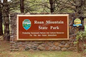
Roan Mountain State Park (RMSP) sits at the base of Roan Mountain.  Roan Mountain rises 6,285 feet above sea level and there is no better way to see all of Roan Mountain then by sending a weekend at Roan Mountain State Park.  Swimming, hiking, fishing, camping or staying in a cabin, all of this and more await you in one of the most beautiful state park on the Tennessee side of the Smoky Mountains.

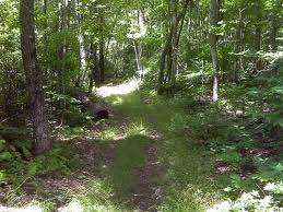
Roan Mountain is the big draw for this state park.  The twisting mountain road that gets you to the top are only part of the fun.  The hiking trails at the top of Roan Mountain offer spectacular views of the mountains to the east and the valleys to the west.  Also at the top of the mountain, in the spring, visitors are welcomed by a covering of pink from the blooming of the catawaba rhododendron that inhabit the rhododendron garden.  This garden has one of the best collections of rhododendrons you will find in the Smoky Mountains.  People come from all over the country to see the rhododendrons that bloom in this garden above 3,000 feet.

Roan Mountain State Park gives you plenty of options if you would like to stay overnight.  Many people choose to stay in the campground that includes 107 camp sites.  Or if you want a few more amenities, they also have 30 cabins in the park.  These cabins sleep up to 4 people, have a fully outfitted kitchen, full bath, a wood burner stove and a heater.  You can stay out in the wilderness without having to break out the tent or pull in an RV.

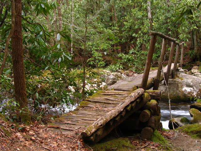
While you are at the RMSP you can fish, hike or swim (during season).  Or you can take part in one of their many special events:

Roan Mountain State ParkWinter Naturalist Rally
Easter Egg Hunt
Spring Naturalist’s Rally
Jr. Trout Tournament
Memorial Day Celebration
Diamond Jubilee
Rhododendron Festival
Independance Day Celebration
Jr. Ranger Camp
Xtreme Roan Adventures Youth Rally
Fall Naturalist’s Rally
Chili Cook-off
Autumn Harvest 
Halloween in the Campground
Old Time Yule

Make sure that you visit Roan Mountain State Park, the next time you are in the Smoky Mountain area.  Depending on your visit, you may want to take the time to drive to the top of Roan Mountain and check out the rhododendrons when they are in bloom.  Spend some time at the base of the mountain exploring the many activities that RMSP has to offer people that visit the area.
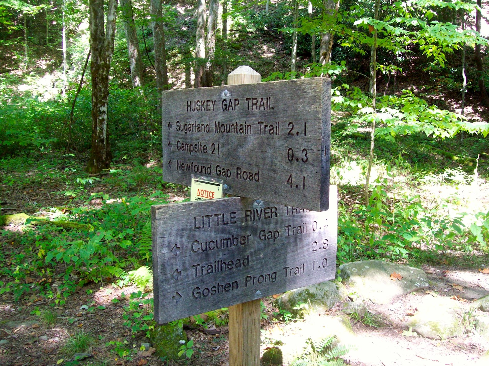
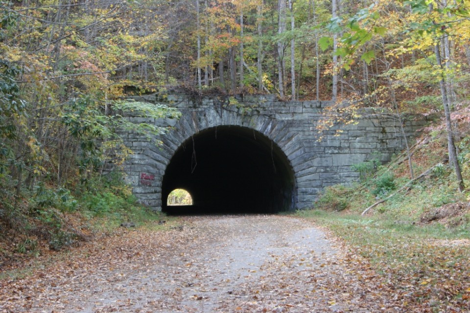
Jonas Creek Trail

The 4.1 mile Jonas Creek Trail in the Great Smoky Mountains is an uphill hike complete with scenic views and sporadic cascades as it makes its way from the junction of the Forney Creek Trail at backcountry campsite No. 70  to the trail’s meeting with the Welch Ridge Trail.

To reach the Jonas Creek Trail, you’ll have to really be wanting to hike this section of the national park. First, hikers must travel the Forney Creek Trail to the starting point – 3.7 miles north of its junction with the Lakeshore Trail.

Hikers begin by crossing a foot log over Forney Creek and passing through backcountry campsite No. 70 – a horse camp as well. You’ll go on to cross Jonas Creek once you reach 0.4 mile on the trail. The rocks are slick and mossy so take care as you cross the stream. The trail becomes rocky on the other side and you’ll pass a majestic waterfall just to the right of the trail.

After crossing Jonas Creek a second time, you must skirt or walk through creek runoff as it flows over the trail. At this point it’s a very wet walk along the trail. You’ll cross Jonas Creek a third time but there is a rock hop to help you across.

You’ll hike across Jonas Creek a couple more times before you reach the junction with Little Jonas Creek 1.3 on the trail. You’re on the way to Welch Ridge. Some of the various trees you pass along the way include sassafras, sourwood, oak, and American beech. Yanu Branch follows the trail and you’ll eventually have to cross it by way of a foot log.

The next part of the Jonas Creek Trail is especially eye-catching so be sure you’ve packed a camera. The 100-foot cascade that comes up on the right of the trail is very notable. This is followed by a series of switchbacks that make up the trail before you start your climb up Yanu Ridge. You reach the top at the 3.4 mile marker. The finale of the Jonas Creek Trail is reached at the junction with the Welch Ridge Trail. Enjoy the Smokies!

Hannah Mountain Trail

If you’re looking a pretty good 9-miler in the Smokies, look no further than the Hannah Mountain Trail which stretches from Parson Branch Road to the junction of the Hatcher Mountain and Abrams Falls trails at Abrams Creek.

This is a great trail for taking in some spectacular Smoky Mountain views as you’ll be doing a fair share of ridge hiking as you make your way along the 9.5 mile trail.

To get to the trailhead at Sams Gap, make your way to Cades Cove in Townsend, Tn and start out on the Cades Cove Loop Road. From there, you’ll turn off Loop Road just past the Cable Mill historic structure and follow the signs to Parsons Branch Road. The trailhead at Sams Gap is 4 miles from the start of Parsons Branch Road.

This easy walking trail begins its ascent up the ridge and through a beautiful wooded area before you reach a large tulip tree – the first significant natural marker found along the trail, 1.9 miles in.

Mount Lanier is reached by way of the Hannah Mountain Trail. It’s also the highest peak on the trail. Hikers descend Lanier toward Bell Cove in to a mixed hardwood forest of hickory, maple, and hemlock among other species.

Hiking around the north end of Hannah Mountain, you soon find yourself coming upon Flint Gap and backcountry campsite No. 14. Flint Gap gets its name from the blue flint that was once found in this section of the national park.

Continuing on the trail, you’ll find that it tends to curve back before passing what remains of a large chestnut tree. At one time there was a cabin that sat in the area just past the fallen chestnut which was home to several pioneer families.

The next portion of the Hannah Mountain Trail starts out at a climb. This is known as Polecat Ridge and it goes on to descend to Scott Gap 7.6 miles along the trail. Backcountry campsite No. 16 is located around 100 yards below Scott Gap. A quick suggestion, if you’re planning on camping at this campsite get there early, especially on weekends. It’s a rather popular spot in the park.

The rest of the Hannah Mountain hike will be a fairly steep ascent to the Abrams Creek junction. You’ll have to ford the creek yourself to get across. Hope you enjoyed the Hannah Mountain Trail!

Hatcher Mountain Trail

So you’ve decided to make it a day trip to the Smoky Mountains and you’re looking for an easy day hike that will let you take in some of the national park’s beautiful hardwood forests but won’t leave you gasping for air at the end. Well, if you’re asking us, we’d tell you to seek out the Hatcher Mountain Trail.

The Hatcher Mountain Trail is a 2.8 mile hike from the Cooper Road Trail to the junction of the Hannah Mountain and Abrams Falls trails. To get there, park at the rangers station at the Abrams Creek Campground in the Smokies. From there it’s a 4.9 mile hike to the trailhead along the Cooper Road Trail.

Starting out on the trail, you’ll slowly ascend the southern slope of Hatcher Mountain through a picturesque hardwood forest. Oaks and pines can be found along the path as you pass over the ridge and descend to Oak Flats Branch. However, flat is a relative term for this area of the Hatcher Mountain Trail.

Soon enough though you’ll find yourself making your way along a wooded hike again. Beautiful, yet small wildflowers can be found in abundance in this area as you hike to the junction of Little Bottoms and the Abrams Falls trails. Enjoy the rest of your day in the Smokies!

Huskey Gap Trail

Another Gatlinburg trail, that is in relative close proximity to the popular Smoky Mountain vacation town, the Huskey Gap Trail is a moderate 4.1 miles from Newfound Gap Road to the Little River Trail.

It’s a great trail if you’re just looking to get out in the woods for a bit, but you want to stay close to town.

Reaching the trailhead, all it takes a trip down Newfound Gap Road for 1.5 miles. You’ll be traveling southward from the Sugarlands Visitor Center and can park at the second quiet walkway that you come to on the left. The trailhead is across the road.

As you start out, notice the rock wall that follows the trail on the right and just below the path. As you’ve probably already guessed, this was once a Smoky Mountain homesite linking these dwellings to the Sugarlands community. This a wonderful trail to hike in the spring time as wildflowers align both sides of the path before you begin the upward hike.

Flint Rock Branch can be heard as you move along the trail, which you must pass over soon. Once you’ve reached that point, you can catch some great shots of Mount Harrison, English Mountain, and Mount LeConte to your right.

Approaching Huskey Gap, you can look off the trail and spot Gatlinburg and all the cabins and chalets that surround the popular Smoky Mountain town. Old Huskey Gap Road lies right below the gap on the right as you move on. Around the turn of the previous century, the Huskey Gap school even operated in this area educating children who lived in the Sugarland Branch community.

The Huskey Gap trail was a popular route for early Smokies settlers who worked in the Little River Lumber Camps. Soon you’ll pass the trail’s junction with the Sugarland Mountain Trail. You’ll soon cross Big Medicine Branch, then the trail will level off and make a more gradual decent to Little River where you’ll cross over a dry stream bed.

Backcountry campsite No. 21 comes up on the left moving along. Reservations are required to camp at this backcountry site. A few more steps and you’ve reached the junction with the Little River Trail and the completion of the Husky Gap Trail. Let us know your experiences on the Huskey Gap Trail in the comment section below. We’d love to hear them!

Lakeview Drive

The Road to Nowhere

This six-mile drive is also known as “the Road to Nowhere” and affords great views of Fontana Lake.   Lakeview Drive ends one mile beyond a viaduct at the mouth of a tunnel. Work on the road stopped in 1943 and was never continued. “The Road to Nowhere” actually takes you to some nice hiking trails. Lakeshore and Tunnel Trails begin at the end of the parking area. The Lakeshore Trail is one of the newer trails in the Park, extending along the south boundary for about 44 miles. It is actually a configuration of trails developed from old manways, older existing trails, and roads.

This road was constructed shortly after Fontana Dam was constructed and Lake Fontana was formed.  With the flooding of the towns of Judson and Proctor, the Great Smoky Mountains National Park needed a way for people visiting the park to get to the park side of Fontana Lake.  The people that had been displaced from Judson and Proctor also needed a way to reach the cemeteries that were located inside the boundaries of the National Park.

They were promised a road that would extend into the park and all the way to these areas that were cut off.  The construction of Lakeview Drive began in 1943 and though progress was slow it continued until 1972 when funding ran out and the construction halted.  The matter of whether this road would be finished was batted around on a local, state and federal level until 2010 when it was decided that a payout would be made to Swain County, North Carolina instead of the road being completed. Now, to reach the areas of the flooded cities that are inside the GSMNP, they either have to hike overland or wait until the one time a year when the park service takes people across the lake for a homecoming time at the cemeteries.

For this reason, Lakeview Drive is known as the Road to Nowhere.  You can drive this secluded road into the park and take in the beautiful views of Fontana Lake.  Also, if you are into bicycling, this area is not as traveled as most and it gives you a chance to bike without having to worry about a lot of cars.  The road ends at the start of several trails and at the last tunnel that was constructed.  The tunnel was finished and is even paved.  You actually walk through the tunnel to get to the trails.

To get there, travel south on the Newfound Gap Road into Cherokee NC. In Cherokee, turn right on US 19 and drive 10 miles to Bryson City. At the old Swain County Courthouse, turn right onto Everett Street and cross the Tuckasegee River. Follow Everett Street through town (it changes to Lakeview Drive) and continue to the Park boundary. Continue 5 miles into the Park.

Hughes Ridge Trail

For those of you looking for a way to get to the Appalachian trail, but would like to get a bit further into the Smokies backcountry beforehand, the Hughes Ridge Trail is an excellent way to begin your trek to the AT. In all, it’s a 5 mile trail, though you will forced to hike 5 miles before you reach it. If you’re a wildflower enthusiast, it’s totally worth the trip during those ripe spring months.

To get there, you’ll take Newfound Gap Road from Gatlinburg to the Smokemont Campground. Just past the ranger station you’ll find the trailhead for the Bradley Creek Trail which you’ll take for 1.1 miles until it intersects with the Chasteen Creek Trail. Stay on it for 4.1 miles until you reach the Hughes Ridge Trail.

Along the Hughes Ridge Trail, hikers will make their way from the very top of the Chasteen Creek Trail to Pecks Corner at the Appalachian Trail. This area was home to numerous pioneer families as well as a number of Cherokee Indian families before the land was went into the hands of the government and became a part of the Great Smoky Mountains National Park.

Starting out on the trail, you should quickly become aware that this is prime wildflower country, especially in the spring. Flame azalea and mountain laurel are just two species people come looking for, camera in hand, or backpack.

Hikers pass the junction with the Enloe Creek Trail before descending the Hughes Ridge Trail, then rising again through a ridge covered with red spruce and other species typically found in the higher elevations of the Smoky Mountains like Catawba rhododendron.

Once you reach the 2.5 mile mark, the junction with the Bradley Fork Trail, the continues along what is described as a wide jeep track. It’s a rocky go as you begin the hike uphill. It eventually reaches a beautiful ridge top.

At mile 4.3 a utility shack can be seen along the trail before continuing through the spruce forest and climbing to the Appalachian Trail at Pecks Corner.

Go-Kart Tracks

Who doesn’t like to ride go-karts.  For small children this might be their introduction to driving.  For young adults this is the height of competition, racing around the track at breakneck speeds trying to see who can cross the finish line first.  For the older ‘kids’ in the group this is a chance to be a kid again.  To climb into the go-kart and race your friends, no matter how old they might be or to chase your kids around the track , this is the thrill of racing a go-kart, this is the reason that you will find go-kart racks and other family adventure venues all over the map in the Smoky Mountain area.

You will also find that there are several different types of tracks in the Smokies:

  • Slick Track – Slick tires on a track that has been oiled.  You will find yourself slipping and sliding around every turn.  Not for the timid, the slick track is harder to find then it used to be but a lot of fun.
  • Wooden Track – These became big in the Smokies in the early 2000s.  Wooden tracks allowed the owners of these tracks to take the go-kart tracks ‘up’ instead of out.  Climbing around a tight circle before a steep descent is the norm with these tracks.
  • Kiddie Tracks – Designed for those younger kids in mind.  You can probably find a track in town that will let all but your youngest children drive around and around and around.
  • 3/8 Scale Tracks – The fastest tracks that you will find.  These are almost half scale cars that go FAST.

The Track
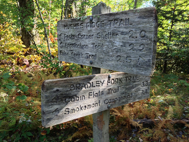
The Track – This is one of the biggest family fun parks and go-kart locations in Pigeon Forge.  Along with the go-karts you can play in the bumper boats, bungee jump, ride the Skyflyer or play in the Kid’s Country.

NASCAR Speedpark – This might be the premier place for go-karting in the Smokies.  With a 3/8 scale track that gets you as close to NASCAR action as you are apt to find.

Cherokee Fun ParkCherokee Fun Park – Located in beautiful downtown Cherokee, NC, this fun park has a little bit of everything.  Go-karts, an arcade, rides and more.  Walk around downtown Cherokee and then spend a little time in the fun loving atmosphere of the Cherokee Fun Park.

Cove Mountain Trail

cmt2So what’s a good trail in the Gatlinburg area? That’s a question that gets asked countless times each year from people visiting the area. Well, if you’re looking for a good, hearty hike, let up suggest the Cove Mountain Trail – an 8.5 miler starting at the Great Smoky Mountains National Park headquarters and ascending Mount Harrison to the summit of Cove Mountain.

There are a number of spectacular views along this trail as well as a few waterfalls so be sure to pack a camera not matter what season you’re hiking in.

To say that this trail features a myriad of landscapes and sights would be selling it very short. From forests to homes and wildlife to ski resort, you’ll see it all. It’s almost man versus nature.

At 0.1 miles you come to the first cascade – Cataract Falls. It’s a small, 12-foot falls that offers some cool relief during the summer months. This is also a great place to take notice of the beautiful wildflowers that take root in the Smoky Mountain soil during the spring.

cmt1Continuing along the trail, Double Gourd Branch tumbles and rolls across the trail and onward through the mountains . Keeping walking, you’ve got at least another 8 miles of climbing ahead of you. The trail will come to parallel Dry Pond Branch before you reach an actual backyard at 1.5 miles and the park boundary.

A majestic view, like that at mile 3.1 of Mount LeConte, is just one of the highlights of this climb. The boundary comes into view again around mile 3.4 as hikers notice the chair lift to Ober Gatlinburg. You’ll see it again as you traverse Mount Harrison before finally leaving the sights of Gatlinburg all together.

Hickory Falls Branch is followed by the trail around a few turns before starting the steepest climb of this journey. The Cove Mountain Wildlife Management Area comes into focus so be wary. A lot of hunting goes on in this area of the Smokies when such things as deer and wild hog are in season. Late fall is prime season so bright colors wouldn’t be the worst thing you could pack.

It’s an easy hike from here to the top and the fire tower. If you choose, you can take a side trail to Laurel Falls or just double back to park headquarters and the Sugarlands Visitors Center.

Deeplow Gap Trail

deeplowgap1Hikers will cross their share of streams and then some, as well as hike past Little Creek Falls, along the 6.1 mile Deeplow Gap Trail.

To reach this Smoky Mountain trail from the end of Deep Creek Road, hike 3.6 miles on Deep Creek and Indian Creek Trails. At the start, you’ll hike to the right past a bench along Indian Creek. You”ll pass George Branch by bridge at approximately 0.1 miles on the trail before coming to an old homestead at 0.2 miles in.

You soon ascend the trail with George Branch following along on the left and come to backcountry campsite No. 51 soon after. Hikers continuing on will crisscross a smaller branch as you hike Deeplow Gap.

deeplowgap2
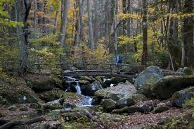
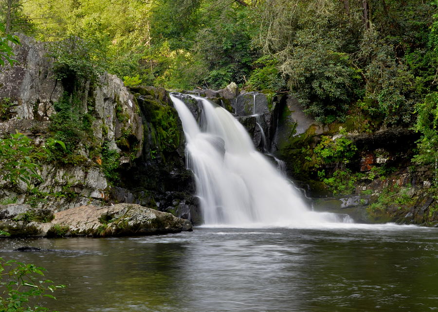
At mile 2.2, the trails meets the intersection with Thomas Divide at Deeplow Gap. Descending the divide’s eastern slope, you’ll cross by way of a foot log over Little Creek and come to the top of Little Creek Falls at 2.9 miles. You’ll descend to the base of the falls where it cascades over 95 feet to its majestic ending below. Another foot log crosses the bottom of Little Creek where you’re bound to get sprayed just a bit depending on the wind.

You’ll cross Little Creek again and some more foot logs before reaching a clearing that marks an old home site. Little Creek flows to the right till its intersection with Cooper Creek. Meanwhile, hikers come to the trail’s junction with the Cooper Creek Trail at mile 3.7, hikers will continue northward on the Deeplow Gap Trail. Another foot log is approached at 4.1 miles in and soon thereafter you’ll notice the remains of two chimneys – the site of a one-time farmhouse.

Another foot log must be crossed at 4.9 miles over Cooper Creek before ascending the ridge crest at 6.1 miles and the junction with Mingus Creek Trail. Happy hiking!