Mount Mitchell State Park

Mount Mitchell State Park
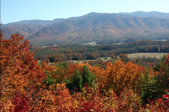
The highest point east of the Mississippi River is Mount Mitchell.  Rising more than a mile into the sky, Mount Mitchell is as majestic from the bottom of the mountain as it is from the peak.  The facilities at Mount Mitchell allow you to learn more about the geology and history of this amazing land mass.  Also while you are there, you can picnic, hike and spend the day on the tallest piece of land on the east coast.

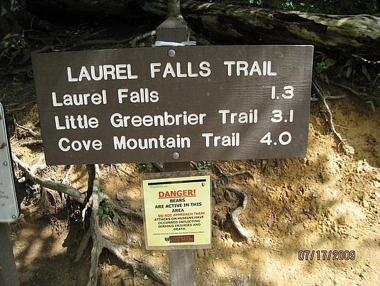
Clingman’s Dome, the highest point on the Tennessee side of the Smokies is nothing in comparison to Mount Mitchell.  From the base this monolith seems to scrape the clouds.  On most days, Mount Mitchell is surrounded by a mist of clouds that seem to be unable to get high enough to go over the top of the mountain.  Once you drive to the park you might decide to hike to the top at the summit platform.  This is a short walk but it literally gets you to the highest point on the east coast.  You breathe will be taken away by the incredible view of the mountains and valley around you.

Hiking is only one of the activities at Mount Mitchell State Park.  You can camp on the mountain, picnic or learn more about the history and structure of Mount Mitchell itself.  If you are wanting to bring a small group or a school group, they have small classrooms and prepared materials to teach about the land, the ecology, the wildlife and how Mount Mitchel has figured into the history of our country.

Mount Mitchell State Park

Mount Mitchell State ParkAnd make sure that you visit the exhibit hall.  In the hall, look for the information about Big Tom Wilson.  They have a replica of the cabin he lived in and even artifacts from his life.  Big Tom was one of the guides that led the scientist to the peaks of the mountain during the 19th century.  He is also the man that went in after Dr Elisha Mitchell’s body when he did not return on his last trip up the mountain.  Of course, Mount Mitchell is named after Elisha Mitchell, the person that pushed for the naming of Mt Mitchell as the tallest peak.

Mount Mitchell is a stop that everybody needs to make at least once when while you visit the southern Appalachian mountains.  If you are cruising around the North Carolina side of the Smokies, make the drive up Mount Mitchell.  Explore the summit and learn more about the area and the people.  Take in the scenery, shoot some pictures, do some hiking and have a great day on top of the world on the east coast.

Pisgah National Forest

Pisgah National ForestThe Pisgah National Forest is a 500,000 acres of land in Western North Carolina.  This national forest, composed mostly of hardwood trees, is also full of action.  Whitewater rivers, waterfalls, and trails aplenty, there is always something going on in the Pisgah National Forest.  Pisgah also has a lot of history that you can explore while you learn about not only this national forest and the national forest system as well.  Between the outdoor activities and educational opportunities the Pisgah National Forest is always ready to entertain.

The Pisgah National Forest borders the Great Smoky Mountains National Park and the Cherokee National Forest in Tennessee.  The lands contained in the Pisgah National Forest were once a haven for the logging industry.  Now those former logging trails are roads and bike paths that allow visitors to experience all that the Pisgah has to offer.  Pisgah National Forest contains the Pisgah, Grandfather and Appalachian Ranger districts so the number of mountain peaks in the Pisgah National Forest is astounding.  As you drive through Western North Carolina you will pop in and out of national forests and state parks all the time.  You will at some point find yourself in Pisgah.

Pisgah National ForestThis area was worked over by the lumber industry before the creation of the National Park and the National Forests.  The hardwood forest were dollar signs for the logging industry.  It is hard to imagine today as you walk among the huge trees in the Pisgah National Forest that at one point this area was almost deforested.  Contained in the Pisgah National Forest was one of the first forestry schools in the United States.  Now it is the site of the Cradle of Forestry in America Historic site.

When you find yourself in the Pisgah National Forest you are in store for as many activities as you can stand.  Biking, camping, fishing, hiking, water activities and much more are around every turn in this national forest.  Whether you are just looking to have a picnic in the outdoors or if you are looking for that adventure that involves boating, kayaking, ATV riding or anything else, the Pisgah National Forest might be the best place to spend a long weekend while you are visiting the Smoky Mountains and the southern Appalachians.

Nantahala National Forest

Nantahala National ForestNantahala National Forest (NNF) is one of the four national forests in the state of North Carolina.  Administered by the United States Forest Service this is the largest of the four, containing more than 530,000 acres of land.  Named for the Nantahala River, this land used to be part of the hunting grounds and tribal lands of the Cherokee.  Now, the NNF is a hugely popular recreational area and if you are driving around on the North Carolina side of the Smokies you are bound to find yourself in the Nantahala National Forest at some point.

The term Nantahala means the Land of the Noonday Sun.  The reason that the Cherokee gave the land this name is due to the extreme valleys and physical features of this terrain.  At some places in the NNF the land does not see the sun until the sun reaches its highest point in the sky.  The word has also given its name to the famous river that runs through the national forest.  The Nantahala River is one of the best rafting rivers in the Smokies.  The Nantahala Outdoor Center has made its home in the valley of the river and provides thousands of people with experienced rafting guides to take them on an adventure down the river each year.

Nantahala National ForestThroughout the Nantahala National Forest, you will find recreational opportunities.  Unlike the Smokies there are designated areas that allow you to take an ATV into the mountains and enjoy a ride on a 4 wheeler.  There are rafting and other boating opportunities along the various rivers and streams.  Parts of the NNF also give you a chance to do some of the best bass and trout fishing that you will find in North Carolina.  The NNF never ceases to amaze those people that pass through it and find that they need to spend an extra day in the mountains just to see what the Nantahala National Forest has to offer.

If you are traveling through the Smokies in North Carolina, once you head south from Cherokee, you will be in the NNF until you reach the state line.  Many great mountain towns are contained in the national forest:  Dillsboro, Franklin, Cashiers, Highlands and Robbinsville – to name a few.  Explore the NNF.  Get out there and see what it has to offer.  Play and stay in the towns contained in this, one of the most beautiful national forest in the country.

North Carolina Arboretum

NC ArboretumIf you’re from Gatlinburg, or East Tennessee, you’ve likely made the short day trip over to Asheville, NC to eat, shop, visit Biltmore, etc. If you’re an outdoors-type person, or more specifically, if you’re into trees and plants, one place you should know about is the North Carolina Arboretum, if you don’t already.

To become more familiar with trees, plants and nature, visit an arboretum. The North Carolina Arboretum is dedicated to providing insight into the trees, plants and nature of North Carolina – especially those located in the Great Smoky Mountains National Park.  The arboretum’s revolving yearly exhibits ensures visitors a chance to see something brand new with each visit. The North Carolina Arboretum puts on a revolving show throughout the year, from the exhibits in the Baker Exhibit Center to the gardens outside there’s always something new and interesting to learn.

NC ArboretumThe arboretum’s sustainable shelter project has been on display since the fall.  This particular exhibit gives examples of how people can use recycled materials and natural fibers in their daily life.  One such example is the garden shed which not only captures rain water, but also recycles the water that you use when you are tending to garden plants.  Not only is the garden shed an exhibit, it’s actually being used in the upkeep of the gardens around the shed itself.  Another exhibit shows how mud-daub houses are made with natural materials. All these exhibits demonstrate the arboretum’s views about how these materials can be used to help benefit the planet. More scientific explanations for the need of sustainable shelters will be available in the exhibit hall as well.

Besides the educational aspects of the arboretum, there are also a slew of recreational opportunities.  Numerous trails wind around the grounds of this 434-acre facility.  In all, there are 65 acres of cultivated gardens in this park.  From the winding path in the one of the most unique bonsai gardens in America to the straight trails at the quilt garden, the arboretum’s natural beauty will ease your mind and put your cares at ease while you explore the grounds.

NC ArboretumA huge collection of sculptures also calls the arboretum’s gardens home.  This outdoor art collection reflects the culture of the region and is all a representation of the area’s local artists.  Take a self-guided tour of the art walk. There are brochures to get you started. The two indoor facilities also house collections of arts and crafts. Paintings of the natural landscapes in the area to mountain crafts are just a few of the noted works.  Be sure to visit the arboretum website before your visit so that you can make the most of your time at the North Carolina Arboretum.

The arboretum is centrally located in Asheville, NC, and only minutes from the Great Smoky Mountain National Park.  The cost to enter is $8 per vehicle so it is also a very cost effective place to visit during your Smokies vacation.  The North Carolina Arboretum is a natural history museum that you definitely want to add to your itinerary.

Biking the Smokies

If you brought your bike with you into the Smoky Mountains you are in for a treat.  Even though bikes are not allowed on any of the trails in the National Park, there are plenty of places to bike while you are visiting.

  • Biking in Cades CoveCades Cove – This is possibly the most biked area of the GSMNP.  Due to the low elevation and the gentle rise and fall of the roads makes this a great place to bike for the whole family.  You don’t have to be an experienced bicycler to enjoy a trip around the 11 mile loop road in the mountains.  Also, the park service shuts down motor vehicle traffic in Cades Cove on Wednesday and Saturday morning so that the bicyclists have the area to themselves, until noon.
  • Cataloochee – Another great place to take a bike.  The roads inside the valley are flat and give you plenty of space to ride around and enjoy the pristine beauty of this location.  While you ride you will be able to take in the not only the natural beauty but the wildlife that calls this valley home.
  • Newfound Gap Road – Not for the faint of heart or the inexperienced,  if you are a serious ‘biker’ this is a grueling uphill climb from the Sugarlands visitors center to the top of the mountain.  Be sure to keep the drivers in mind and use the pull-offs to keep traffic flowing.
  • Foothills Parkway – The Foothills Parkway has long been a source of consternation to the people of Tennessee, but if you have a bike with you, you will be hard pressed to find a more beautiful place to ride in the mountains.  After a brief climb from Townsend, you will hit a nice relatively straight road that doesn’t see a lot of traffic and is a great place to put some miles on your bike.
And if you are looking to do some mountain biking, don’t be sad because you can’t tackle the trails in the GSMNP.  The state parks and national forest on both sides of the mountains provide plenty of trails that you can get on for the adventure of biking on the mountain.  These areas are designed for mountain biking and you will have room to enjoy yourself while practicing this extreme sport.

If you didn’t bring a bike, there are places where you can rent a bike while you are in the area.  One of the most popular is the Cades Cove Campground Store.  Either while you are staying in the campground or while you are visiting Cades Cove for the day, a bike from the campground store will give you a way to cruise around the campground or to tackle the Cades Cove Loop Road.  Also, if you are in one of the towns around the Smokies and you need an accessory for your bike or a repair, there are a number of bike shops ranging from small mom and pop stores to mountain bike shops that can help you replace a chain or a set of brakes.

Laurel Falls Trail

  • Laurel Falls Trail4 miles in length – 1.3 miles to Laurel Falls
  • Starting Points – On Little River Road between Sugarlands Visitors Center and Elkmont
  • Points of Interest – Laurel Falls
  • Difficulty – 1 to the falls – 3 to the finish of the trail

This might be the most popular and most hiked trail in the national park.  The first section, the 1.3 miles to Laurel Falls is paved and wide.  This trail was cut in by the Civilian Conservation Corps in 1935 and since that time and the opening of the park, people have flocked to it.  Now, that being said, the first part of the trail, the section that leads to the falls, is the popular part.  After that point, the trail gets a lot steeper and rougher to hike.

When you hike the first 1.3 miles to the falls you will be greeted by a wonderful waterfall that is highly photographable and beautiful. The falls plunges 75 feet from its apex.  There is a new cement bridge that allows you to safely cross to the other side of the falls and then down to the base where you can splash in the crisp mountain water, picnic or just take advantage of a place to rest before you start up the trail again.

Laurel Falls TrailAfter you have had a rest at the base of the falls, you will start your climb to the end of the trail.  The paving stops at this point and the trail narrows so that you are going to need to walk single file most of the time.  The final 2.7 miles climbs from around 2600 feet to almost 4000 feet.  The trail becomes a lot more strenuous and you will find the need to take breaks from time to time.  There is one good thing about the rougher terrain though – the fires in the park and logging didn’t reach this area.  You will hike through Old Growth Forest!  You will see some of the largest trees in the national park.  If you are up for the hike, make sure to hike the full 4 miles.

If you are planning on hiking the whole trail you are going to want to get an early start and due to the parking area and the popularity of this trail, you will need to get there early to find a place to park.  Especially on the weekends, parking is a premium at Laurel Falls.  Also, keep in mind this is not a loop trail.  So the full length of the trail is 8 miles, not just 4, you have to hike back out.


Shuckstack Tower

Length: 6.8 miles roundtrip
Difficulty: Medium to Strenuous
Highlights: Excellent views of Fontana Lake and the Smokies
Caution: Steep terrain can be slick in snow or rain, or on fallen leaves
Note: Best hiked on a clear day to enjoy the view.
Directions: Shuckstack is on the North Carolina side of the Park. From Bryson, take NC 28 to Fontana Dam. Start your hike from the north side of the dam.

Hike to Shuckstack Tower

The historic fire towers of the Great Smoky Mountains National Park were once used to gain a bird’s eye view of the mountains in order to spot forest fires. Though many of the towers were removed as more modern methods for fire detection were developed, Shuckstack and three other towers remain. These out of the way destinations are well worth the extra effort, and the vistas they provide are by far better than any view available from any roadside overlook.

Located on Twentymile ridge, the Shuckstack fire tower is just a tenth of a mile from the Appalachian Trail and a mere 3.4 miles from the road. The quickest and easiest way to access the tower is to begin on the north side of Fontana Dam, which is on the North Carolina side of the Park. Please note that the dam is under renovation at this time, and vehicles are prohibited from crossing the dam. Foot traffic across the dam is allowed, however. The section of road you have to walk to reach the trailhead is nice and level, but it will add a little over a mile to the roundtrip distance of the hike.

As you cross the dam, scan the mountains to the north and you’ll be able to make out the tower in the distance. Fontana Dam is a monumental piece of engineering, and is the largest dam east of the Rocky Mountains; the lake is over 400 feet deep at full pool! Continue across the dam, take a right, and you’ll find yourself at the Appalachian Trail in a little over half a mile. Now begins the fairly challenging ascent of Twentymile Ridge. The trail is uphill nearly from the start – just remember that slow and steady wins the race. Take breaks as you need them, and you’ll find that the three and a half miles to the tower isn’t as daunting as most make it out to be. You’ll notice that there are plenty of short but flat stretches on the trail that allow you to catch your breath, and plenty of fallen logs and rocks to sit on and rest along the way. Though it’s often difficult to gauge your progress, you will have glimpses of the tower from time to time (especially in winter months). At around two and a half miles the trail will level considerably, and the walking will be easy for the next half mile or so. Then, about a quarter of a mile from the tower you’ll encounter your steepest climb (it’s mercifully short, though). Once on Twentymile Ridge, you’ll encounter a three-way intersection. The AT is marked with simple white line blazed on the trees, while the path the tower is marked with a white “T”. From here, the tower is just a tenth of a mile.

The Shuckstack fire tower is actually a small wood and metal building perched atop a winding eighty-foot staircase. You’ll no doubt see that the view from the rocks at the bottom of the fire tower is incredible, but the view from the tower is much better. As you begin to climb the tower, you’ll notice that it moves ever so slightly, but don’t be alarmed. Wind continuously blows acrossView of Fontana Lake from Shuckstack Tower 
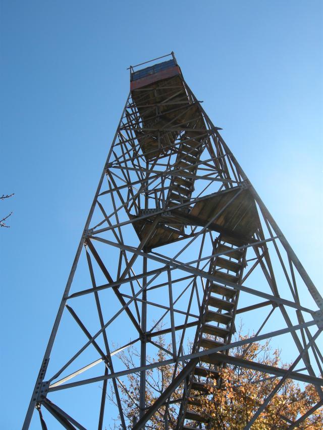
this ridge, and the tower is made to give a little. From the top of the tower, you’ll be awarded a spectacular 360-degree view, with mountains in all directions. The Unicoi Mountains can be seen to the west, the Snowbird and Nantahala Mountains to the south, the Blue Ridge Mountains to the southeast, and the Smokies to the east and north. Remember looking up at the tower as you walked across Fontana Dam? From this vantage point, you’ll be able to make out the dam and all of the land you covered on your way to the tower. You’ve covered about three and a half miles and climbed over two thousand feet. It’s a rewarding feeling indeed. To return to your car, simply descend from the tower and return the way you came.

If your trek to Shuckstack is a day-hike, take a knapsack and carry a few extra items. Include some bottled water and a snack. Never drink the water from a Park stream without boiling it first. Though the streams in the park are invitingly cool and deceptively clear, they contain bacteria that can wreck your trip and a substantial period thereafter, if you succumb to the temptation to drink from them. You might even include a camera in your knapsack too. A backcountry permit is required for overnight stays in the backcountry. Certain campsites are reserved in advance. Permits are available at visitors centers or by calling (865) 436-1231.

Rich Mountain Road

Have you ever wondered where the two roads that branch out of Cades Cove go?
Rich Mountain RoadHere is where you can find these two roads in Cades Cove:

  1. Rich Mountain Road – Before the halfway point around Cades Cove, and the entrance is across from the Cades Cove Missionary Baptist Church.
  2. Parsons Branch Road – At the halfway point around the loop road, at the same intersection that takes you into the Cades Cove Visitors Center.

But, let’s talk about Rich Mountain Road.  Once you have gotten to the turn off across from the Cades Cove Missionary Baptist church, you are going to find yourself on a dirt and gravel road.  Be ready for a bumpy ride but also be ready to get even further away from civilization than you were in Cades Cove. This trip is going to take you up Rich Mountain and then back down into Townsend proper.

Rich Mountain RoadThis is a rustic road.  It is closed during the winter and if there has been a lot of rain , it is impassable during any time of the year. Parts of it are prone to being washed out but it is a great experience and you get to see parts of the GSMNP and the Smoky Mountains that you will not get to any other way.  Now that you have been warned, take the road.

The road ascends into the wilderness.  Don’t expect to go straight up or straight down ut do expect a very windy, twisting drive into the mountains.  This is a one way road, so you are not going to meet an oncoming traffic.  What you are going to meet are some of the most spectacular views that the Smokies have to offer. You will also get to see plenty of wildlife.  Now, that being said, remember that you are not in Cades Cove anymore.  The animals along Rich Mountain Road are not quite as tame and they will run a lot easier then the animals in Cades Cove.  Once you have hit the top of the mountain and start your descent you are going to cross several streams and see plenty of cascades and waterfalls.  You are in some areas that see a lot less travel then other areas of the Smokies.

One of the most photographed scenes from Rich Mountain Road is a small Baptist Church that you can see int he valley from the top of the mountain. During the fall, as you can see from the photo is gorgeous.  If you look in some of the galleries around the area, you will find many artists have chosen to reproduce this scene in their artwork.

Rich Mountain Road is definitely worth a trip the next time you are in Cades Cove.  Make sure you are prepared for the trip and take this rustic road into the mountains.