Chimney Tops Trail

To reach the Chimney Tops trailhead from Gatlinburg, Tennessee, take Newfound Gap road into the park. Newfound Gap road is the only road which completely traverses the Great Smoky Mountain National Park, linking Cherokee NC to Gatlinburg TN. From the Sugarlands Visitor Center, continue 6.7 miles until you reach the parking lot at the Chimney Tops trailhead. The parking lot and trailhead is located between the lower tunnel and “the loop” on Newfound Gap road. If traveling from Cherokee to Chimney Tops, take the Newfound gap road twenty-two miles from Oconaluftee Visitor Center.

Once at the trailhead, there is plenty of room for parking, but the trail itself is sometimes a bit crowded due to its popularity. A tour bus in the parking lot means more people on the trail, so if you are looking for a back-to-nature experience along this trail, you may enjoy a hike to Chimney Tops during off-season. If so, beware of ice in really cold weather, as the trail is steep, rising 1,300 feet from the trailhead to the chimney-like pinnacles which give this trail its name. Ice tends to form early at the higher elevations of the Great Smoky Mountain National park. The highest point of Chimney Tops trail is 4,840 feet above sea level.

The Chimney Tops Trail begins at the low rock wall bordering the parking lot area. Here you will find Eastern hemlocks. The trail descends to a bridge across the Walker Camp Prong of the Little Pigeon River. In fact the trail crosses several bridges and tributaries along the one mile hike to Beech Flats. The second and third bridge both cross the Road Prong and guide the hikers on to the next landmark, Beech Flats Cove. This is approximately the half way mark of the trail. At Beech Flats, the Chimney Tops Trail crosses the Road Prong Trail that in turn leads to the Appalachian Trail at Indian gap 2.3 miles away. If your destination is Chimney Tops, you will want to stay on the main trail that veers right into a creek valley on the north side of Sugarland Mountain. This part of the trail cuts through an inspiring old growth forest, but beware of tree roots which have tripped many a hiker as they admired these old giants of the Smokies. At the top of the gulch, you’ll see one of the oldest yellow Buckeyes in the Park, and just beyond the Buckeye are two sharp switchbacks that take the hiker to the bottom of the Chimneys as they rise from Sugarland Mountain.

The upper end of Chimney Tops trail is not a graded trail as it was in the beginning. The upper end of the trail narrows to a smaller trail called a manway. Narrowing, the trail continues on quite a distance. At its steepest point, the manway becomes an arduous climb–especially if ice has formed on the trail. The terrain can be rugged in places.

Two miles into the hike, you will be able to see the chimneys themselves. Care should be taken as you follow the path to the right that leads to the top. Here you can see Mount Le Conte to the east, Mount Mingus to the south, and to the west, a steep wooded side of Sugarland Mountain. Injuries have occurred in this area, as there is a hole large enough to fall into, so take precautions to keep yourself and your loved ones safe.

Despite the obvious risks, even the upper end of Chimney Tops trail is worn smooth in places by the hoards of hikers willing to risk life and limb to experience “the chimneys”. Why? Adventure perhaps? Or perhaps the urge to explore the chimneys for themselves? Perhaps others go simply to be edified by the breathtaking views of the surrounding mountains, while others go to enjoy the abundant beauty of the old growth forest and flora to be found there. Whatever the reason, the popularity of this trail continues season after season.

There are many plants of interest along the length of Chimney Tops trail. Old Hemlocks grace its top, and flowering trees and shrubs dot it’s length. See how many you can recognize along your walk. To get you started, there is a large Fraser magnolia near the first bridge along this trail. Its blossoms are large, white and pretty hard to miss when in bloom in late April or early May.

Rhododendron is abundant along Chimney Tops trail. Also common are a variety of wildflowers. In Spring, you can find Trillium (right) and Hepaticas (left). In Summer, Joe-Pye weed, Bee-balm, and Jewelweed can be found. Violets, Toothworts, and Foamflowers also grow nearby. On the trail to the Chimneys people rave about the yellow buckeye trees due to the age of these trees and their unusual leaf structure and the flowers which appear in May. A trek to Chimney Tops will make you understand why it is so popular. You will probably want to return on your next visit to the Smokies–and get fit in the process!

Narrative and photo contributed by Jacqueline Thompson

Gunter Fork Trail

gftWhen you look at the Gunter Fork Trail on a map, it can take you aback at the trail’s steep climb, but when you realize it’s only a 4.1 mile hike in the Smokies, it doesn’t seem that bad, even for the novice hiker.

This route starts out at the junction with Camel Gap Trail and finishes at the intersection with the Balsam Mountain Trail. You’ll actually start out on the Big Creek Trail and hike for 6.1 miles to reach the Gunter Fork Trail. It’s a great trail to take if you want to see some Smoky Mountain cascades and do some creek hopping in the process.

The name of the spot that the Gunter Fork Trail begins is called Walnut Bottom. If you’re looking at a map of the park, it’s just past backcountry campsite No. 36. To say that the Gunter Fork Trail offer nature lovers a smorgasbord of appealing qualities would be  putting it about right. Streams, cascades, views and vistas, many types of plants, trees, and animals can be found along this trail which is another reason it has become so popular.

You’ll cross Big Creek once you’re on the trail. You might even see if you can spot some Smoky Mountain trout if you decide to hang around a bit before walking on. Gunter Fork is crossed at 0.3 miles in before ascending again through the forest, then again at the 0.9 mile mark. A beautiful pool is reached by way of a side trail at 1.4 miles and then you come to the previously mentioned cascade at 1.8 miles – 150 feet high.

The trail’s last creek crossing is made soon after and then you begin a series of switchbacks. You’ll continue your steep ascent of Balsam Mountain. This is a great place to be in the middle of fall as the foliage in this area as countless people have referred to it as “magnificent” and “breathtaking” as well as other synonymous words. You reach the crest of Balsam Mountain at 4.1 miles, as well as the meeting point with the Balsam Mountain Trail. The Laurel Gap Shelter lies 1.1 miles to your left. Enjoy the Smokies!

Juney Whank Falls Trail

Though the Juney Whank Falls Trail is only 0.3 mile, it packs quite a punch at the end. It’s sole purpose is to take hikers to one of the most picturesque falls in the Great Smoky Mountains National Park – Juney Whank Falls.

To reach this trail, you’ll drive over to the North Carolina side of the park to Bryson City. From there, you’ll follow the signs through downtown to the Deep Creek Campground in the national park. Once you reach Deep Creek itself, don’t cross it, just park at the area at the end of the road. You’ll find the trailhead at one end of the parking area.

Juney Whank actually takes its name from the Cherokee Indian tribe and means “place where the bear passes”. Although you’re as likely to see a bear here as you would be anywhere else in the national park. Others say it gets its name from Junaluska “Juney” Whank, who according to historians was said to have been buried near the falls.

As you make you’re way along the trail, signs point the way to the falls and as you get closer the roar of the water gets clearer and clearer. You’ll soon find a narrow path that travels away from the trail to the base of the falls.

Probably the best spot to view the Juney Whank Falls is on the foot bridge located across Juney Whank Branch. From there, you can either turn around or head on down the trail to the next junction. Though you probably want to stay around the falls for a bit.

Mt LeConte Lodge

Hiking to Mt. LeConte Lodge

For viewing spectacular Smoky Mountain sunrises and sunsets, there is no better place than Mt. LeConte. Countless visitors have huddled together to view the sunrise from Myrtle Point on the eastern side, and hurried to see the sun set over Clingman’s Dome from Clifftops on the western flank.

The idea for a lodge on top of Mt. LeConte to accommodate visitors dates back to 1925, when Paul Adams established a permanent camp for the Great Smokies Conservation Association, an organization formed to seek national park status for the Great Smokies. Many prominent visitors spent the night at the early tent camp as guests of the Association in order to win their support for a park in the Southern Appalachians. Where else could you provide a better grandstand view of the Smokies than from the summit of Mt. LeConte?

Today, LeConte Lodge is the highest inn providing lodging for visitors in the East. Although LeConte is the third highest mountain in the Park at 6,595 feet, it is actually the “tallest” mountain in the Eastern United States, rising over a vertical mile from Gatlinburg. Rustic accommodations include the lodge, a dining hail, and a cluster of small cabins equipped with double-bunk beds. Dinner at the dining hall is served at 6 p.m., breakfast at 8 am. A pack-train of llamas brings food, bed linens, and other supplies to and from the Lodge three times a week. These animals do not damage these heavily used trails as much as horses.

LeConte Lodge can accommodate an average of 45 guests per night, and normally fills up a year in advance. Reservations are required for the lodge and for the 12-man lean-to shelter (with bear-proof chain link fence across the opening) near the lodge. There is no charge for staying at the shelter, but reservations are required through the Park’s backcountry office.

What to Bring: Since your dinner, breakfast, and bed are provided, you can pack light! Some essentials: light-weight hiking boots, a small backpack or daypack, flashlight, water, compass, knife, matches, lunch for the day you go up and a light snack for the return trip, rain gear (it rains a lot in the Smokies and even more on LeConte), hat, gloves, washcloth and towel, toothbrush, soap (you won’t need your shampoo—no showers!), toilet paper, a clean shirt and two pairs of socks (dry socks will he needed!), and money for a souvenir (you may want to buy a T-shirt). Other items that will help you enjoy your trip include: a camera, film, and binoculars (to view the peregrine falcons nesting the bluffs near the summit).

Article & Photography by Robin Bible

Old Settlers Trail

Bird Creek

The first creek crossing is at Bird Creek. The adventurous may hike up the west side of the creek and find the remains of a few home sites – four once existed along this creek. One fireplace will be found a few hundred yards up the creek, but more picturesque ones will be found further on OST. The trail passes two large stone outcropping on the right about 100 yards apart, and then it begins to climb a small ridge beside the river. At one point, the river can be seen down below, through the rhododendron. It then curves around the ridge and descends to cross a small tributary. One homesite exists up this small valley. On the left the astute observer will see the old-road bed. The trail widens as it merges with the road to become one. The adventurous may follow the old road to the river and discover, upstream, remains that once held a walk bridge over the river.

Little Bird Creek

The trail continues into Little Bird valley. One short stone wall will be seen on the right and then another as the trail narrows between the creek and the stone wall. Some say the walls were used as boundary lines; others say they were used to keep livestock. The trail crosses over Little Bird Creek and continues up the valley parallel to the left fork of Little Bird Creek. A white pipe exists behind a tree on the right with a metal tag on the tree. These markers are used for research in the park. The trail then turns west and crosses over a deep trench that contains the left fork of Little Bird Creek during the rainy seasons. The remains of what supported a small bridge can be seen in the trench. The tail then climbs up alongside the left fork a few hundred yards. Another short wall of stones can be seen on the south, across the drainage area. In a few more paces, at the point where the trail veers perpendicular to the left fork of Little Bird Creek, the homesite belonging to the wall of stones may be seen. OST zigzags west and north several times as it gradually climbs Copeland Divide. The ridge of Copeland Divide can be seen to the north. It passes through a forest of young hemlocks, sassafras, maples, and oaks. It continues past a large 100 year-old oak and a shagbark hickory as it approaches the crest of Copeland Ridge, turns to a 20-degree east-northeast heading in a flat area on the ridge top and continues for several hundred yards at a 2200′ elevation. It crests the ridge and descends on the northern side with a large hollow on the left. This is the watershed area for Copeland Creek. OST zigzags north and east as it continues in an east-northeast direction. In the late fall and winter when the leaves have fallen, the trail will darken as it enters into a hemlock forest. An unusually large holly tree is seen on the right as the trail gradually climbs back up to 2200′. Here it passes between two large old oaks. This is a good place to take a rest or have a snack. The trail then descends past a large, split tulip poplar tree on the left and zigzags through hollows continuing its course east-northeast. It goes through a pine forest, a deciduous forest and into another cluster of pines as it approaches Copeland Creek.

Copeland Creek

The slope is very steep on the left of the trail as enters into another rhododendron thicket – indicating a watershed. Pipsissewa can be seen growing on the forest floor and the sound of Copeland Creek can be heard. As the trail crosses over the creek the old road, overgrown with young trees and brush, can be seen to the left as it follows Copeland Creek down into the valley. Early settlers once inhabited this valley. The old 1932 map shows that eight homes once existed along Copeland Creek – with the last of the eight above the creek crossing and to the right of the trail. West of the junction of the creek and a tributary, near the 1400′ elevation, Bonwell Chapel once stood. Five more homes once existed up along this tributary, three more below the chapel along side Copeland Creek and two more up Left Fork. After crossing Copeland Creek the trail ascends through a large mountain laurel thicket and enters another unusually flat area for more than a hundred yards. A tall pin oak stands above the thicket on the left and in the autumn its colorful red leaves identify it. It then begins to descend past a stand of large oaks, over one hundred years old, on the south. What appears to be a ravine on the right of the trail becomes the trail as it switches back from a northern heading to a southern heading. It goes through a rhododendron tunnel with a ridge to the right and a small mountain peak on the left 1/4 of a mile away. Large loblolly pines are seen on the left and a ridge on the left blocks the view to the north. As it continues it turns to a southern heading at Cat Stairs pinnacle can be seen straight ahead, to the south, above the trail. The trail descends into a hollow as it enters a quiet region of mixed conifer forest of pine and tall hemlock. It continues is descend to the headwaters of Snakefeeder Branch.

Snakefeeder Branch

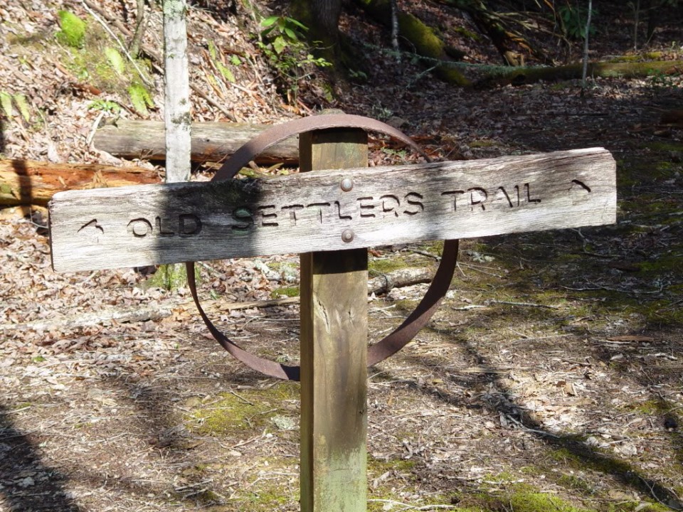
OST crosses the headwaters of Snakefeeder Branch where several settlers once lived. A fallen chimney will be seen on the right, and the vegetation noticeably changes. More sunlight enters this valley and cane grass, ferns and little brown jugs can be seen on the forest floor. Another fallen chimney is passed on the left of the trail and a large grapevine hangs beside the trail. A third chimney in a large flat clearing is seen on the left, then OST crosses the creek and continues down with the creek on the left, or west of the trail. It soon approaches a signpost identifying Old Settlers Trail. Across the deep creek bed is a road that leads up to old Lindsey Cemetery. Beyond it another road leads to 321, so in an emergency this can be used as a quick access out. However, OST goes east through a large brushy area and crosses Soak Ash Creek.

Soak Ash Creek (elevation 1400′)

Another settlement existed in this very flat area. The trail continues another half mile and soon crosses Evans Creek as it goes through more rhododendron and pine to a signpost. Behind this signpost is a trail that leads to Steiner Bell Lodge and highway 321.

Evans Creek (elevation 1424′)

The choices are right, or west to Greenbrier and the Little River, or left, east toward Cosby. Turning left the trail follows Evans Creek gradually uphill. The old map shows a road going south less than 400 yards from the intersection and another going north 50-100 yards beyond. The southern road shows 7 homesites, and the northern shows two, along with Fairview School and continues to intersect 321. It also shows the old road going due east and nearly straight to Timothy Creek – it does not appear to veer south around a ridge on the old map, as the trail seems to do – check it out! OST then levels, until it crosses Timothy Creek.

Timothy Creek

On the other side of Timothy Creek are the remains of a chimney with the “V” hearth and a smokehouse next to the creek. Beside it is an old roadbed that continues up alongside the creek. A few more home sites existed upstream. The trail then climbs up alongside the roadbed for about 400 yards, passing a stone wall that runs from the trail to the old roadbed, then it turns left (el. 1803) and continues past several stone walls on both sides of the trail. It continues a few hundred yards and crosses Darky Branch Creek, which is surrounded with rhododendron then goes around a ridge with a view to the left to the condo units at Cobbly Knob directly to the north.

A little further on the trail exists a signpost identifying OST. Near it, another unmarked trail can be seen on the west side of the trail that begins down a ridge top and eventually leads to highway 321 I about 6/10th of a mile. Martha McCarters Road can be seen on the opposite side of the highway and to the east about 3/10th of a mile is a restaurant. This unmarked trail may be used in case of an emergency, but be prepared to climb over and under fallen logs. Be forewarned that when going off trail in the summer months you may encounter snakes.

Old Settlers Trail continues around the ridge to the right to campsites 33A and 33B next to an old fallen fireplace. Both sites have posts marking their location and the park service has erected wires and pulley to hang food and gear high above the reach of animals. Beyond campsite 33B the trail begins to descend to Redwine creek. The old map shows two or three home sites upstream from the intersection of OST and Redwine Creek. The continuance of the original road can be seen to the right before crossing the creek.

Redwine Creek

After crossing Redwine Creek the trail goes up a slight rise and around a ridge in a southeast direction then up along a ridge through an extensive outgrowth of mountain laurel. There are views to the west as the trail climbs the ridge and at one point the trail passes around a large sandstone outcropping (elevation 2000 feet) it continues south through a pine forest with soft needles on the trail. The Cobbly Knob ridge can still be seen behind – if you look to the north. Then the trail goes east around the ridge (from the topographical map it looks as if the trail is at the 2200′ line) and enters into a flat area before it turns to the left and begins its descent to Ramsey Creek. We nicknamed this Bill’s hill after Bill Steiner, who has hiked it many times with me. On the right of the trail in the brush, almost out of sight, is another fireplace with a fallen chimney. There are some big old-growth trees, several hemlocks, on both sides of the trail and a very steep ravine on the right, which is the source of the creek. Perhaps the steepness of the ravine kept the loggers out. The trail drops 500′ rapidly over a couple hundred yards with Ramsey Creek on the right.

Ramsey Creek

OST crosses the creek and will cross it again four more times. A pile of stones up on the right may have been another chimney. Further down the ravine is another chimney on the left of the trail. The trail crosses the creek again and continues down into Ramsey Creek ravine, until another fireplace with a fallen chimney is seen on the right – broken parts of a crock pot lie around it as well as a piece of a fire stove. After crossing Ramsey Creek several more times it climbs up and west, out of the Ramsey Creek ravine, goes though a forest mixed with pine and deciduous trees, to an elevation marker 1969 feet (identified on the old 1932 map). It curves around a ridge and comes upon stone walls first on the right and then on both sides of the trail. On the right or east is one of the few remaining full, standing chimneys with a “V” hearth in the fireplace. This “V” hearth is distinctive among the chimneys on OST. In fact, there are two fireplaces on each side of this chimney. The stone walls continue along OST and further along a pile of stones exist on the same side as the chimney – I assume it is a fallen chimney, for the 1932 map shows another house existed here. In the fall when the “acoustical” vegetation has fallen to the ground, the noise from highway 321 can be heard to the west. Eventually the trail makes a sharp east-southeast turn to the right. On the left is the original OST hidden and overgrown. It then climbs up about 650 yards through a forest of green rhododendron, until the sounds from Noisy Creek can be heard as the trail approaches the creek.

Noisy Creek

A few hundred yards before Noisy Creek are two signposts identifying OST; one sign points west and one east. Between the signs is an unmarked man-way that leads 6/10 mile down to highway 321. Only in an emergency should this old trail be used, for it is unmarked and often seems to disappear into the creek. It has fallen trees on it that have to be climbed over and under, and is dangerously close to a steep hill at one point. It will pass through a dark pine forest where the remains of a few homes still exist. As the sounds of the highway are heard, the trail veers left, passes a wall of stones and then crosses a small creek and eventually ends up on the highway next to a sign for an underground cable. To the left one-half mile is the entrance to Cobbly Knob where there is a security guard.

At the two signposts the trail continues east, and remains of an old home site are seen on the right, just before it crosses Noisy Creek and climbs again. Up the trail climbs until it comes to another homesite in a large clearing. At this point you may cross the creek to the right and return to the trail in 50 yards by crossing back, or you can stay on the left and cross its small tributary and rejoin the trail on the left side of the creek. It then climbs up and passes another old chimney. Up, up the trail climbs then turns left away from Noisy Creek. It follows another deep ravine on its left, which I believe is the source of Tumbling branch – a tributary of Noisy Creek. It is so deep no sound of Tumbling Branch can be heard. It appears to cross over the ridge around 2900 feet and then descend to Texas Creek.

Texas Creek

A bench marker is burried near the headwaters of Texas Creek – elevation 2789. Another chimney from a homesite can be seen on the right with a wash bucket on it and further down on the right another chimney with the “V” hearth in it. Down the trail goes though rhododendron thickets until it comes upon a lengthy stone wall five feet high on the right side of the trail. The wall continues to Webb Creek, and it is most unusual in that it exists on both sides of Old Settlers trail for some distance.

Webb Creek

After crossing Webb Creek hikers have a choice of continuing on OST to the right, or south, to ascend a small mountain, or straight ahead. If OST is followed, it will climb and then cross over

Snag Mountain and then descend into a beautiful valley where the trail crosses Snag Branch, just beyond one homesite on the left. A few stone walls will be found in the valley and two homesites on the left. Fifty yards beyond can be seen second home site, where the remains of another collapsed chimney are found. About fifty yards further a cemetery will be found. One old sandstone headstone reads 1877. Careful observation will reveal that most of the cemetery contains very young children. Many children died of childhood and other diseases that were incurable at that time. Continuing on the trail crosses Dunn Creek, Spring Branch and Indian Camp Creek before it eventually intersects the trail that goes to Albright Grove to the south or to highway 321 and Laurel Springs Road to the north, or Cosby, past Henwallow Falls to the east.

However, at Webb Creek, if you go straight-ahead about 100 yards, it will lead to a wide old road, and the roof of McCarters pioneer barn can be seen straight ahead. Beyond the barn the home site can be found with the remains of two chimneys, and beyond the chimneys a small smoke, or springhouse can be seen. Or, at the intersection of the unmarked trail and the old road there is another unmarked trail on the left that leads about 800 yards back to highway 321 and a small parking area. Or, if you follow the wide old road, it will also lead to highway 321 where you may park.

Narrative and photo contributed by Gary Acquaviva
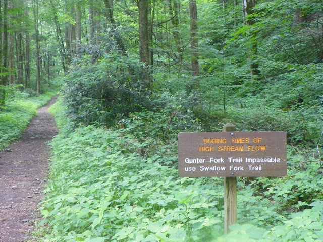
Big Creek Trail

The Big Creek Trail is a fairly moderate and a good hike for beginners and new hikers. You could actually say the trail moves at a steady incline once you begin at the trailhead – located at the Big Creek Picnic Area.

The trail is rather easy to reach from Interstate 40 in Tennessee traveling east. Exit 451 is the specific marker you’ll be looking for. Take a left following the exit and proceed 2.3 mile after crossing the Pigeon River. You’ll pass the Big Creek Ranger Station before reaching the trailhead at 3.4 miles.

As previously mentioned, the Big Creek Trail is a great hike not only due to the encouraging landscape, but for the number of water features you pass along the trail. It’s an area rich with history as numerous Indian tribes and various people used the trail to travel from Tennessee to North Carolina and back.

After arriving at the trailhead, you’ll have noticed the parking area and ranger station. The Big Creek Trail officially begins just uphill from the parking area. On its way to Walnut Bottom, the Big Creek Trail ascends steadily throughout making its way along the creek. One mile into the trail, a vague trail breaks off to the Rock House, which is visible from the trail. This shelter of rocks was once used by loggers working the area at the turn of the last century.

At 1.4 miles you reach one of the big draws to Big Creek Trail – the Midnight Hole. This large, deep, green pool attracts people from everywhere wanting to enjoy the beauty of the Smokies and cool off at the same time. Mouse Creek Falls comes up at the 2 mile mark – another great site for the photography lover in everyone.

Brakeshoe Spring is crossed at mile 2.8 and hikers will notice to mossy grey stone and the tiny spouts dipping under, through and beside the rocks.

At 5.1 miles into the trail, a sign for the Swallow Fork Trail, which climbs 4 miles to Pretty Hollow Gap on the Mount Sterling Ridge Trail, comes into view. Backcountry campsite No. 37 – Lower Walnut Bottom,  is reached at 5.3 miles. Hikers come to the end of the Big Creek Trail at 5.8 miles which is the location of the Upper Walnut Bottom Campsite (No. 36 and reserved solely for horse parties) and the junction with the Camel Gap Trail.

Deep Creek Trail

A number of backcountry campsites can by found along the Deep Creek Trail in the Smokies as well as a number of Smoky Mountain streams the crisscross the trail through its length. In all, it’s a long, 14.2 mile hike for Newfound Gap Road to the trail’s meeting with Deep Creek Road.

Hikers can find the trailhead 1.7 miles south of Newfound Gap along Newfound Gap Road. According to the history books, the Deep Creek Trails was one of the first trails established following national park establishment. It was designed by R.P. White, an engineer, who considered the Deep Creek Trail to be the most beautiful trail he ever designed.

deepcreektrail1At the trailhead, you start out on a switchback before descending to Deep Creek and winding through a few other coves. Here, small streams run across the trail and wildflowers can be found in bunches around every turn. A mile and a half in, hikers must jump a stream and a mile later you get a better idea of the number of different trees, wildflowers and tributaries that makes their way around the trail. At mile 3.5, Deep Creek makes an appearance and lets it be known what a great fishing spot it is. If you happen to bring a rod and reel, jump in, just have your license on you.

Backcountry campsite No. 53 appears at mile 3.9 on the trail. It’s a well-used campsite and not the most appealing of all the one located along this trail, but definitely one that can be used nonetheless.

The next couple of miles are spent bopping and weaving along Deep Creek. Many times it just makes the hiker cross it regardless of water level. Deep Creek rises and falls, rushes and slows at various points not giving so much as a care to the hiker.

A campsite is approached about every half mile once you get 6.5 miles into the trail. These backcountry campsites are numbered 54-59, some are very appealing, others are average, it’s your choice.

Hikers are now traveling up and down throughout the landscape, some muddy, some not. The Martins Gap Trail intersection comes up at campsite No. 57, or Bryson Place. The descent to campsite No. 60 soon follows around 11. 7 in. It’s one of the more picturesque sites on this trail for all you camera carriers.

You’ll cross Bumgardner Branch by way of a foot bridge and at 12 miles you’ll come to a gravel road then a mile later come to the Indian Creek Trail intersection before reaching the trail’s end.

Cucumber Gap

The hike to the summit of Cucumber Gap is a relatively easy 2.4 mile hike in the Tennessee Great Smoky Mountains with numerous chances to see spring wildflowers.

To reach the trail, traveling along Little River Road take the turn toward Elkmont and the national park ranger station. Take the left to the campground and park near the sign for the Little River Trail. You’ll hike the Little River Trail for 2.3 miles before coming to the intersection with the Cucumber Gap Trail. In all, it’s a 5.5 mile loop of you include the Little River Trail and the Jakes Creek Trail.

This trail was a big part of the Little River Lumber Company in its heyday during the 1920s and you can tell by the railroad bed or old logging road along the trail. Huskey Branch is crossed 0.3 miles into the trail which may be forded by stepping stones. Just be wary for high water following rain showers. You’ll cross two other branches that are unnamed before reaching the summit of Cucumber Gap.

Fraser magnolias, sometimes referred to as “cucumber trees” can be seen near the top of the gap and is more than likely where the trail gets its name from. Hikers will notice Burnt Mountain through the trees once they reach Cucumber Gap at mile 1.4. This is a great place to take various wildflower pictures in the spring as violets, hepatica, and others bloom here during those months.

From here, it’s a gradual, easy descent into a multiple species forest. Tulip Branch is crossed by hikers on the way down before coming to the trail’s conclusion at the Jakes Creek trail junction.

Boulevard Trail

The Boulevard Trail to Mount LeConte is one of the more popular trails in the Gatlinburg area and rightfully so. In all, the trail runs 5.4 miles (10.8 miles roundtrip) from the Appalachian Trail to the summit of Mt. LeConte.

For most, the easiest route to the junction with the Appalachian Trail is by Newfound Gap and hiking the trail for 2.7 miles until its meeting with the Boulevard Trail.

About 10 or so minutes into the trail, you come to “The Jumpoff”. If this were the Matrix, you’d be asked to choose between the blue and the red pill. What that means for those of you who haven’t seen the movie is that you have a choice. One trail leads to a mile loop, or you can just carry on on the Boulevard Trail.

Hikers will pass the Walker Camp Prong stream further on the trail. At the 1 mile mark, you’ll notice the first overlook from The Boulevard’s crest.

It’s said that once you reach the crest of the Anakeesta Ridge you’ll more than likely be ready for a bit of R & R. This area of the trail is also known for its iron pyrite, or fool’s gold. So if you stumble upon something shiny, don’t get too excited, it’s likely fool’s gold.

Alum Gap is approached after descending Anakeesta’s Ridge followed by the long ascent to Mount LeConte. Along the left side of the trail views of Alum Cave Bluffs come into view as well as Huggins Hell if you look hard enough. During the summer, this is a good place to find plant species like St. John’s-wort.

The trail leads around the eastern side of Mount LeConte from here. Passing under Myrtle Point the trail’s grade doesn’t reflect the steepness the Mount LeConte now shows. In these areas landslides are common as is falling ice in the winter months.

After reaching the summit of Mount LeConte, follow the trail downhill past the shelter and subsequent clearing to the intersection with the Trillium Gap and Rainbow Falls trails. You’ve now reached the end of the Boulevard trail as you notice a cluster of buildings on down that signify LeConte Lodge.

Crib Gap Trail

Here’s an easy Smoky Mountain hike for all you wildlife lovers out there, it’s called the Crib Gap Trail. It’s a breezy 1.6 mile hike from its junction with the Anthony Creek Trail to the intersection with the Turkeypen Ridge Trail and the Finley Cane Trail.

cribgaptrail
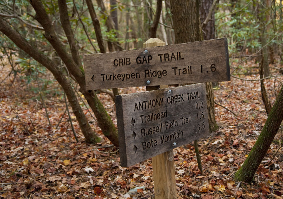
Starting out in the Cades Cove picnic area in Townsend, Tn, it’s a quick 0.2 mile walk along the Anthony Creek Trail to the Crib Gap Trail.

This short trail won’t keep you too far from civilization as the sounds of the road run parallel with the trail. What this trail is, is a peaceful getaway from the tourist trappings of Cades Cove during one of those bustling summer days. As you meet the trail, the rhododendron come out to greet you immediately. It’s also said that wild mushrooms are aplenty on this particular Smoky Mountain/Cades Cove hike.

You’ll eventually come to a small tributary of Anthony’s Creek which you must jump to carry on. Climbing, you’ll come to few switchbacks as you ascend the gap then approach an opening in the trail. When you come to the peak, you’re able to look down upon Crib Gap. Here, rain that falls downhill behind you flows to Anthony Creek and Abrams Creek before being spit out into the Little Tennessee River. Water that falls in front of you drains down to Laurel Creek, the Little River before reaching the Tennessee River. It’s quite a path.

You’re now on the descent to Laurel Creek Road. Be careful when crossing at mile 0.9. You’ll continue hiking about 30 yards after crossing. Watch out for mud, likely due to horses using the trail. The trail ends in an open field and its intersection with three other Smoky Mountain trails.