Alum Bluff Caves

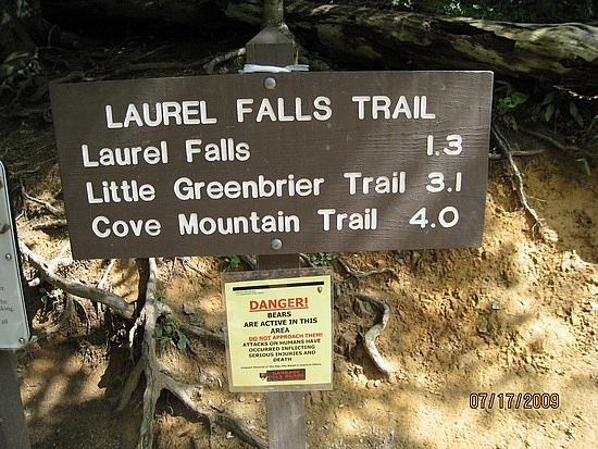
From the Sugarlands Visitor Center, drive 8.6 miles east on Newfound Gap Road. There you will find two Alum Cave Bluffparking areas, where a gravel path leads to The Grassy Patch and the beginning of a 2.3 mile hike to Alum Cave Bluff.

Summary: This moderately difficult hike is 4.6 miles round-trip or 5.1 miles on to LeConte Lodge. The round-trip to the cave bluff takes about 2 and 1/2 hours, but allow about 3 and 1/2 hours to LeConte Lodge. The Alum Cave Trail is the most popular and well-known route to Mount Le Conte.

Elevation: You gain 2600 feet on the way to 6400 feet.

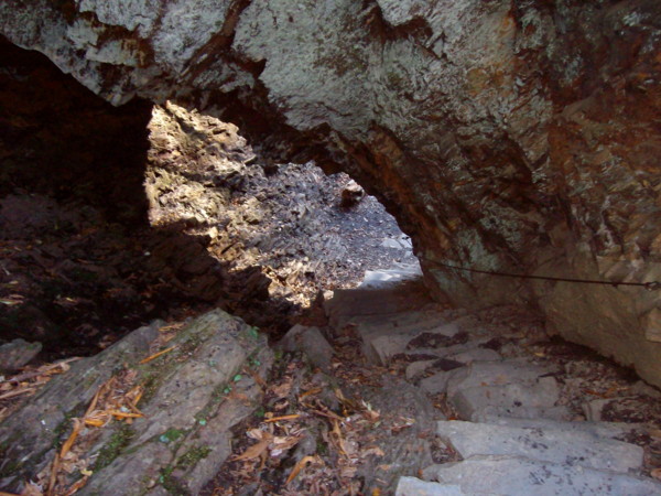
Features: Arch Rock, 1993 summer storm damage, Inspiration Point, Alum Cave Bluff

Mother Nature’s majesty and power are clearly demonstrated in this 4.6 mile (round-trip) hike. The views are great, particularly if you go on to LeConte Lodge and Cliff Tops, and the trail is not too difficult–even for children. To demonstrate, I recall an early visit (I was much younger and more fit) when I carried my sleeping daughter on my shoulder for the majority of the first half of the hike.

You’ll begin this hike at the Grassy Patch just off the parking area. Shortly after entering the forest, you will parallel the Alum Cave Creek for approximately a mile and then follow Styx Branch, a main tributary of Alum Cave Creek. A few hundred yards beyond this point, you’ll see the boulder and log remains of a 1993 flash flood and landslide on your left. A heavy thunderstorm dumped several inches of rain, with a force so great that huge boulders were exposed and tossed–its path is clear to the hiker and will remain so for years. At mile 1.5 you come to Arch Rock, where a set of stone stairs aids your passage through one of the few natural arches inside the park. At the 1.8 mile mark you will come upon Inspiration Point, affording the first panoramic view of the area. Thereafter, you’ll pass through an area of low shrubs, and shortly thereafter arrive at Alum Cave Bluff (mile 2.3). Alum Cave is not what the name implies. Its not a cave–rather it’s a jutting ledge of black slate, forming out over the trail to give the impression of a cave. The name Alum Cave comes from the deposits of alum found along the “cave” walls.

For the hardy souls who will continue on to LeConte Lodge, the trail curves up and around the bluff and begins following the ridge that forms the southern flank of Mount Le Conte.

Two hundred yards from it’s finish at Le Conte Lodge, the trail is joined from the left by the Rainbow Falls Trail. Le Conte Lodge consists of several wood-shingled cabins, two lodges, and a dining room. There is no electricity and water is pumped into holding tanks from a spring. The lodge uses llamas to haul in supplies (that’s a story for a future issue!). Reservations can be made at LeConte Lodge by calling (423) 429-5704.

Above the lodge you’ll find Cliff Top, one of the best vantage points in the Smokies–when the view is not obscured by misty clouds.

If your trek to Alum Cave Bluff is a day-hike, take a knapsack and carry a few extra items. Include some bottled water and a snack. Never drink the water from a Park stream without boiling it first. Though the streams in the park are invitingly cool and deceptively clear, they contain bacteria that can wreck your trip and a substantial period thereafter, if you succumb to the temptation to drink from them. You might even include a camera in your knapsack too. If you are making an overnight trip to LeConte Lodge, you’ll be carrying a backpack, and we assume here that you have included all the necessary items and arranged for the required reservation at the lodge. A backcountry permit is required for overnight stays in the backcountry. Certain campsites are reserved in advance. Permits are available at visitors centers or by calling (865) 436-1231.

Laurel Falls Trail

  • Laurel Falls Trail4 miles in length – 1.3 miles to Laurel Falls
  • Starting Points – On Little River Road between Sugarlands Visitors Center and Elkmont
  • Points of Interest – Laurel Falls
  • Difficulty – 1 to the falls – 3 to the finish of the trail

This might be the most popular and most hiked trail in the national park.  The first section, the 1.3 miles to Laurel Falls is paved and wide.  This trail was cut in by the Civilian Conservation Corps in 1935 and since that time and the opening of the park, people have flocked to it.  Now, that being said, the first part of the trail, the section that leads to the falls, is the popular part.  After that point, the trail gets a lot steeper and rougher to hike.

When you hike the first 1.3 miles to the falls you will be greeted by a wonderful waterfall that is highly photographable and beautiful. The falls plunges 75 feet from its apex.  There is a new cement bridge that allows you to safely cross to the other side of the falls and then down to the base where you can splash in the crisp mountain water, picnic or just take advantage of a place to rest before you start up the trail again.

Laurel Falls TrailAfter you have had a rest at the base of the falls, you will start your climb to the end of the trail.  The paving stops at this point and the trail narrows so that you are going to need to walk single file most of the time.  The final 2.7 miles climbs from around 2600 feet to almost 4000 feet.  The trail becomes a lot more strenuous and you will find the need to take breaks from time to time.  There is one good thing about the rougher terrain though – the fires in the park and logging didn’t reach this area.  You will hike through Old Growth Forest!  You will see some of the largest trees in the national park.  If you are up for the hike, make sure to hike the full 4 miles.

If you are planning on hiking the whole trail you are going to want to get an early start and due to the parking area and the popularity of this trail, you will need to get there early to find a place to park.  Especially on the weekends, parking is a premium at Laurel Falls.  Also, keep in mind this is not a loop trail.  So the full length of the trail is 8 miles, not just 4, you have to hike back out.


Shuckstack Tower

Length: 6.8 miles roundtrip
Difficulty: Medium to Strenuous
Highlights: Excellent views of Fontana Lake and the Smokies
Caution: Steep terrain can be slick in snow or rain, or on fallen leaves
Note: Best hiked on a clear day to enjoy the view.
Directions: Shuckstack is on the North Carolina side of the Park. From Bryson, take NC 28 to Fontana Dam. Start your hike from the north side of the dam.

Hike to Shuckstack Tower

The historic fire towers of the Great Smoky Mountains National Park were once used to gain a bird’s eye view of the mountains in order to spot forest fires. Though many of the towers were removed as more modern methods for fire detection were developed, Shuckstack and three other towers remain. These out of the way destinations are well worth the extra effort, and the vistas they provide are by far better than any view available from any roadside overlook.

Located on Twentymile ridge, the Shuckstack fire tower is just a tenth of a mile from the Appalachian Trail and a mere 3.4 miles from the road. The quickest and easiest way to access the tower is to begin on the north side of Fontana Dam, which is on the North Carolina side of the Park. Please note that the dam is under renovation at this time, and vehicles are prohibited from crossing the dam. Foot traffic across the dam is allowed, however. The section of road you have to walk to reach the trailhead is nice and level, but it will add a little over a mile to the roundtrip distance of the hike.

As you cross the dam, scan the mountains to the north and you’ll be able to make out the tower in the distance. Fontana Dam is a monumental piece of engineering, and is the largest dam east of the Rocky Mountains; the lake is over 400 feet deep at full pool! Continue across the dam, take a right, and you’ll find yourself at the Appalachian Trail in a little over half a mile. Now begins the fairly challenging ascent of Twentymile Ridge. The trail is uphill nearly from the start – just remember that slow and steady wins the race. Take breaks as you need them, and you’ll find that the three and a half miles to the tower isn’t as daunting as most make it out to be. You’ll notice that there are plenty of short but flat stretches on the trail that allow you to catch your breath, and plenty of fallen logs and rocks to sit on and rest along the way. Though it’s often difficult to gauge your progress, you will have glimpses of the tower from time to time (especially in winter months). At around two and a half miles the trail will level considerably, and the walking will be easy for the next half mile or so. Then, about a quarter of a mile from the tower you’ll encounter your steepest climb (it’s mercifully short, though). Once on Twentymile Ridge, you’ll encounter a three-way intersection. The AT is marked with simple white line blazed on the trees, while the path the tower is marked with a white “T”. From here, the tower is just a tenth of a mile.

The Shuckstack fire tower is actually a small wood and metal building perched atop a winding eighty-foot staircase. You’ll no doubt see that the view from the rocks at the bottom of the fire tower is incredible, but the view from the tower is much better. As you begin to climb the tower, you’ll notice that it moves ever so slightly, but don’t be alarmed. Wind continuously blows acrossView of Fontana Lake from Shuckstack Tower 
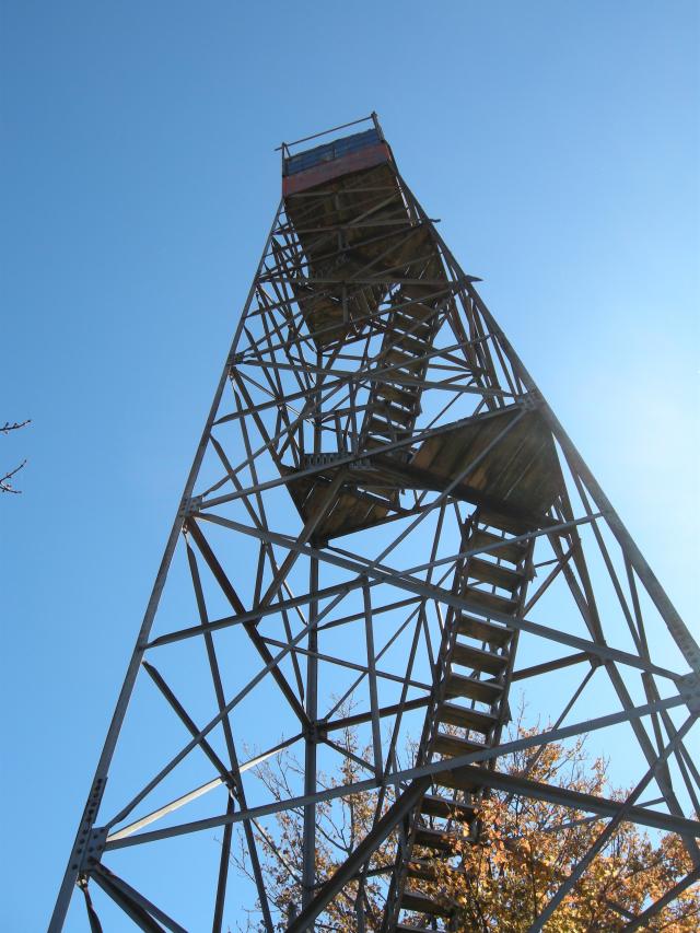
this ridge, and the tower is made to give a little. From the top of the tower, you’ll be awarded a spectacular 360-degree view, with mountains in all directions. The Unicoi Mountains can be seen to the west, the Snowbird and Nantahala Mountains to the south, the Blue Ridge Mountains to the southeast, and the Smokies to the east and north. Remember looking up at the tower as you walked across Fontana Dam? From this vantage point, you’ll be able to make out the dam and all of the land you covered on your way to the tower. You’ve covered about three and a half miles and climbed over two thousand feet. It’s a rewarding feeling indeed. To return to your car, simply descend from the tower and return the way you came.

If your trek to Shuckstack is a day-hike, take a knapsack and carry a few extra items. Include some bottled water and a snack. Never drink the water from a Park stream without boiling it first. Though the streams in the park are invitingly cool and deceptively clear, they contain bacteria that can wreck your trip and a substantial period thereafter, if you succumb to the temptation to drink from them. You might even include a camera in your knapsack too. A backcountry permit is required for overnight stays in the backcountry. Certain campsites are reserved in advance. Permits are available at visitors centers or by calling (865) 436-1231.