Indian Grave Gap Trail

A wildflower famous in and around the Great Smoky Mountains National Park, the flame azalea, is one of the highlights for people seeking out the Indian Grave Gap Trail – a 3.7 mile hike from Rich Mountain Road just outside Cades Cove to the junction of the Crooked Arm Ridge and the Scott Mountain trails…. And the views aren’t bad either.

As mentioned, to get to the trailhead take the Cades Cove Loop Road in Townsend, TN to Rich Mountain Road which is located right across Loop Road from the Cades Cove Missionary Baptist Church. From there it’s 2.2 miles up Cades Cove Mountain. You’ll also have to cross Tater Ridge and Branch, then the Indian Grave Gap Trail veers off the road to the right. At the trailhead there is a small parking area. And just so you know, Rich Mountain Road is usually closed from November-March.

Now, if you think that you’ll find a bunch of Indian Graves on the trail, fear not. No one really knows why it was named what it was, but there are no Indian Graves to be found. Only beautiful views of the Smokies.

However, numerous Indians did pass through these areas when the Cherokee outnumbered the European settlers, especially in the Cades Cove area. You’ll notice at the start of this trail there is a gate which which was used as access for jeeps at one time. You’ll make a moderate climb at the start of the trail before it descends to Indian Grave Gap. For the next mile, you’ll gain over 1,000 feet in elevation.

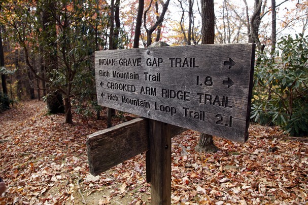
The next marking on the trail is the junction with the Rich Mountain Loop Trail. At that point you know you’re nearing the height of Tater Ridge and almost 1.1 miles on the trail. Take a look off to your right and you’ll see some great views of Cades Cove.

Continuing your climb, along this part of the hike you should notice the flame azalea’s and their bright orange blossoms that erupt in June and July. You’re now ascending Double Mountain which gets its name due to its twin peaks.

The Rich Mountain Trail is met at the 1.9 mile marker and to your left sits backcountry campsite No. 5 – about 100 yards from here. Ahead is Cerulean Knob, 0.3 mile further. The three-trail junction is reached at mile 3.7 and Crooked Arm will take hikers back down to Cades Cove. Happy hiking!


Fork Ridge Trail

Those of you outdoor enthusiasts looking for a downhill jaunt in the Smokies with a back-woodsy feel, look into the Fork Ridge Trail on the Tennessee side of the park. It’s a 5.1 mile hike from Clingmans Dome Road to the trail’s intersection with the Deep Creek Trail.

forkridgetrail1To reach the trailhead, travel along Newfound Gap Road in the park until you reach Clingmans Dome Road and travel 3.5 miles till you reach the trailhead parking area.

From its start, it’s a downhill hike through a number of Smoky Mountain tree species including fir and birch as you descend the Fork Ridge. You’ll notice ferns and rhododendron as you hike the first mile before hopping a stream and coming to a large opening which is full of native wildflowers in the spring.

A small stream is crossed again at the 2 mile mark on the trail. Spruce birch and maple can be seen near the trail at this point. The trail will level out for a bit before heading downhill again.

When you reach 4 miles in, a large dead American chestnut marks this point – said to have been dead for over 50 years and counting now. This is also a drier place on the trail which could possibly have something to do with it.

The Fork Ridge Trail will soon bend left into a more lush forest and hikers will get a good look at Noland Divide. Descending again, keep your eyes peeled for black bears. It’s said that this is a particularly popular place for them and their cubs as they make their way in search of food.

You’ll reach a knife ridge 5 miles on the trail ripe with flowering plants. Creeks now flow on both sides of the ridge and hikers come to a clearing. The sounds of Left Fork and Deep Creek can drown out the other sounds in the immediate area. In spring this isn’t a problem as one’s eyes are distracted by the beauty of the clearing’s wildflower display.

Deep Creek should be coming into view below as hikers finish off the last part of the Fork Ridge Trail. You’ll cross Deep Creek by a wide footbridge before connecting with the trail again on the other side. A left takes you back to Newfound Gap Road, a right takes the hiker to backcountry campsite No. 53 . Hope you enjoyed the Fork Ridge Trail and its Smoky Mountain wonders.

Chestnut Top Trail

If you know the Townsend “Y” is, then you’re halfway to hiking the Chestnut Top Trail in the Smoky Mountains. In all, it’s a 4.3 mile trail filled with Smoky Mountain wildflowers and a slew of great vistas and views of the Smokies that finishes at the Schoolhouse Gap Trail intersection.

The trailhead is located at the intersection of Little River Road and the Townsend, Tn entrance road. There are plenty of parking spots available along the road, as well as in a large parking lot near the “Y”.

Ask most people and they’ll say that the Chestnut Top Trail is best enjoyed in Spring when the wildflowers are in full bloom. Hikers can easily spot near 50 species if you’re so educated. But beware, poison ivy lurks in heavy amounts at spots along the beginnings the trail.

Hiking the trail, you’ll find a smooth slope once you reach 0.5 miles into the hike. You’ll also notice that the forest becomes heavily covered by pines and oaks.

As the trail climbs Chestnut Ridge, you’re met by a set of switchbacks a mile in. Atop the ridge, you’re welcomed by the sight of Thunderhead Mountain and the crest of the Smokies – the highest on the western end of the national park.

At mile 2.8, hikers reach the highest peak of the trail before descending to Bryant Gap. If you look out to the right of the trail, you get a great shot Townsend, to the left is the park.

As the trail moves on it levels out until you reach the Schoolhouse Gap junction. To the left, the trail leads 2 miles to Laurel Creek Road which splits Cades Cove and Townsend.

Bote Mountain Trail

The 6.9 mile Bote Mountain Trail will challenge even the most experienced of hikers among you.

This somewhat rocky hike is accessed via Laurel Creek Road, which is 3.5 miles from the Townsend “Y”. Hikers can park at the Schoolhouse Gap trailhead, nearly 250 years past the Bote Mountain trailhead going toward Cades Cove in Townsend, Tn.

History surrounds the Bote Mountain Trail as during the 1800’s, James Spence tended the Cades Cove farmer’s cattle in a majestic meadow that became known as Spence Field. Hiking the Bote Mountain trail to Spence Field affords the hiker intermittently rocky terrain and rhododendron covered footpaths.

The trail ascends for 1.2 miles before meeting with the junction of the West Prong Trail. Soon you’ll come across another meeting place, this time with the Finley Cane Trail. This is where the climb up Bote Mountain really starts. The sounds of the West Prong accompany the hiker up the flanks of the mountain.

You can almost see James Spence and the Cades Cove farmer’s cattle he tended climbing the slopes as you head up the Bote Mountain Trail. In those days, as it would now, it must have been a difficult climb. It was the grass at the higher elevations that made the effort to push the cattle to such heights worthwhile. It’s said that the high mountain grass was better for the cattle than that found on the Cades Cove valley floor and the considerable reduction in heat and flies in the higher altitudes made for a much more comfortable grazing experience.

Once the peak of Bote Mountain is reached, notice the views of Thunderhead and Defeat ridge. It could be argued that these are a few of the best vistas in the Smokies. From here to the junction with the Lead Cove Trail, the views are breathtaking.

The Anthony Creek Trail joins the hiker at mile 5.2 and descends 3.6 miles to the Cades Cove Picnic Area. Hike on to Spence Field where you’ll come to the junction with the Appalachian Trail and you’ve now fully experienced the Bote Mountain Trail.

Numerous visitors who have hiked the Bote Mountain trail have come to look upon people like James Spence as a very lucky man. His was a life spent overlooking Cades Cove from his mountain paradise. Through its view alone, the Bote Mountain trail is one of the most rewarding to originate in Cades Cove and the entire Smoky Mountains.

Enloe Creek Trail

If you like smaller, more picturesque waterfall made by a Smoky Mountain stream, you’ll love the opportunities afforded to hikers along the Enloe Creek Trail. It’s a 3.6 mile trail from the Hyatt Ridge to the Hughes Ridge Trail, though it can be muddy in places.

To reach Enloe Creek, hike 1.8 miles on the Hyatt Ridge Trail from the Straight Fork Road trailhead – that’s the simplest and easiest route.ect1The part of the park was virtually untouched by the logging companies that plundered the area before it was deemed a national park. Therefore, it’s traveled by many including horses that have torn through the trail at some points. Regardless, the waterfalls produced by Raven Fork and Enloe Creek are worth the hike on its own, separate from the virgin growth forest.

From its beginning, the trail descends immediately into Raven Fork Gorge. A rock outcrop is passed 0.5 miles into the trail and you’ll pass several cascades before reaching Raven Fork a mile in. It’s a large, loud stream, but it does not have a trail that parallels it.

Across the steel bridge on Raven Fork is backcountry campsite No. 47. It’s small and most of the time wet and muddy, but some still brave it out to camp and hear the roar of the stream.

Back on the trail, several more cascades are noticed and passed, some that are blocked by the summer plants that line the forest floor. You’ll cross Enloe Creek by a foot log at mile 2 on the trail.

Climbing the trail, hikers will get a great view of Katalsta Ridge at 2.5 miles. It’s named in honor of a late Cherokee Indian chief’s daughter.

Switchbacks are prevalent before reaching the 3.4 mile mark and entering an open forest. You’ll reach the Hughes Ridge Trail intersection and the conclusion of the Enloe Creek Trail at mile 3.6. Happy hiking!

Caldwell Fork Trail

The Caldwell Fork Trail, located on the North Carolina side of the Great Smoky Mountains National Park, is a 6.3 mile hike from the junction of Rough Fork Trail to the intersection with Cataloochee Road. It’s an easier trail as it’s mostly downhill with meandering streams following along the path.

To access the trail via the Polls Gap Trailhead, take Heintooga Ridge Road north from the blue Ridge Parkway to Polls Gap. Then, follow the Rough Fork Trail 3.5 miles until you reach the Caldwell Fork Trail.

Caldwell Fork gets its name from the second group of settlers to come to the Cataloochee Valley. The trail itself is used by both hikers and horses so don’t be too surprised to find some sections muddier than others. The trail follows Caldwell Fork downstream throughout. You’ll also find beautiful American beech, red maple, and white oak, among others, on this hike.

Hikers will pass old fence posts along the way and grassland, reminding them that there were once lush fields where cows grazed here before reaching backcountry campsite No. 41.

At 1.7 miles, the trail meets Hemphill Bald Trail junction. Continuing on, the trails descends through rhododendron and along the Caldwell Fork on the left. The Clontz Branch is passed without the use of a footbridge. When you’ve reached 3.1 miles into the hike, the junction with McKee Branch Trail appears.

Near this point is where the old Caldwell Fork School once stood. It was one of three community schools in the Cataloochee Valley which also included the schools in Big Cataloochee and Little Cataloochee. Most children during those times split their schooling and farm duties. It was said that school only lasted 5 months then.

The 3.6 mile mark is the first of two junctions with the Boogerman Trail. You’ll see a number of streams cross the trail following this intersection so be sure to watch out and get good footing before marching on. As you reach the end of the trail, be sure to notice Cataloochee Campground on your right as you finish up. It’s a great ending spot for a mildly challenging day hike.


Bone Valley Trail

The hike to Bone Valley Trail is a rather easy 1.8 miler and good one for beginning hikers or people just wanting to make an afternoon of it in the Great Smoky Mountains National Park.

The path starts at the Hazel Creek Trail, Campsite No. 83 to be specific, on the North Carolina side of the park. Getting there is the real fun part. The suggested way is to take a ferry across Fontana Lake to Proctor, then hike 5.3 miles up Hazel Creek to the actual Bone Valley Trail. Easier said than done, right? People say it’s worth the effort, we’ll let you decide.

As you start out from the trailhead, you’ll cross a wooden bridge over Bone Valley Creek before proceeding upstream. The trail follows an old railroad bed before you approach the first ford in the trail. It’s said that water is about knee deep during most seasons and when there hasn’t been a major weather happening.

White Walnut Cove is passed between the first and second fords. This place was at one time said to grow grapes which bears, others animals, as well as settlers vied for in the regions more primitive years.

Mill Creek is crossed after passing a former homestead and connecting farm. The plant Beebalm can be found growing here in June and July.

You come upon the Hall Cabin soon thereafter, following an appearance by the creek a fourth time. The cabin was originally located 200 feet from its current location. Not only is it on the Historic Register of Historic Places, it’s the most remote historic structure in the national park.

The Hall Cemetery is reached about 0.5 miles north of the Hall Cabin. This is unofficially the conclusion of the Bone Valley Trail, though many people sit around and peruse the area of the Hall Cemetery reflecting on the life and times of the area’s earliest settlers. It’s a quiet area and one of the more undisturbed spots in the park.

Gabes Mountain Trail

gmtsignHen Wallow Falls – a very popular and picturesque Smoky Mountain waterfall, is the destination of thousand of hikers every year which means trails like the Gabes Mountain Trail see a lot of action during the spring and summer months.

The 6.6 mile Gabes Mountain Trail is well worth the hike not only because of the falls, but for the old growth forest found surrounding the trail.

To reach the trailhead, from Interstate 40 in Tennessee take the Foothills Parkway to Cosby, TN. Take Tennessee Hwy. 32 at the Cosby Post Office, turn into the park and head toward the Cosby Campground. Park at the campground registration building and cross the road to meet the trail.

The trail is sheltered by mountains and giant trees of every species to its north. You’ll cross a number of small creeks by foot log on your way as well as a side trail back to the Cosby Campground. An old traffic loop that used to take visitors to Hen Wallow Falls is passed before you notice a number of old home sites along the trail on the other side of the loop. You can tell by the old chimneys.

Continuing on, the trail ascends and crosses another creek before rising past some large rocks and at mile 2.1 you come to an offshoot which takes one right down to the base of the falls. You’ve reached Hen Wallow Falls.

Goshen Prong Trail

goshenpringtrailLooking for a way to get to the Appalachian Trail and a little warm up as well? The Goshen Prong Trail in the Great Smoky Mountains is a great way to do just that and take in a number of beautiful mountain streams, as well as a cave, on the way.

In all, it’s a 7.6 mile journey from the Little River Trail to the Goshen Prong’s intersection with the AT. To get there, travel to the Elkmont Campground in Gatlinburg and park at the Little Rive trailhead. You’ll hike 3.7 miles up the Little River Trail till you come to its junction with the Goshen Prong Trail.

Starting out on the trail, you’ll notice a fairly wide trail and a rather easy climb. You’re hiking on old logging railroad beds that signals that the area was once logged heavily before being designated a park. Railroads were what got the logs out of the forests in those days. You’ll soon cross the Little River by way of an iron bridge.

Continuing on the trail, notice the ferns and mosses that now appear. You’ll also notice some old stone walls left over from the logging days. This is a great area to view a number of Smoky Mountain wildflowers during the spring and early summer.

You’ll see the creek cascade about a mile in on the trail, as well as two waterfalls before you start on the rocky, sometimes muddy, portion of the trail. That doesn’t that for long as an easier path comes into view among American beech trees. You’ll also notice a few fern fields along the trail – great places to sit, take a break and just admire the beauty of the Smokies. The path to backcountry campsite No. 23 is also passed along the trail. It’s one of the prettier backcountry sites, around 100 yards off the trail.

You’re now 4.4 miles from the intersection with the Appalachian Trail, traveling left and through a rhododendron thicket. You’ll soon drop down to Goshen Prong and a few pools, and continue on the trail crossing a few more creeks before reaching the cave.

The cave is on the left and can provide a bit of shelter from a rain cloud. However, try to keep away from such structures during a lightening storm.

Continuing on, you’ll cross a dry creek bed before hiking a rocky last mile of the trail. At the junction with the Appalachian Trail you’ll see a trail sign and the familiar white blazes marking the AT. Good luck on the trail!

Jakes Creek Trail

Just outside Gatlinburg, Tn you’ll find the Jakes Creek Trail, a short hike in the Smokies that takes visitors into the national park and gives them the option of using one of the many backcountry camping sites located throughout the park. In all, it’s 3.3 mile hike from Jakes Creek Road to Jakes Gap.

To get to the trailhead, start out at the Sugarlands Visitors Center in Gatlinburg and take Little River Road traveling west. Take the turn into Elkmont at mile 4.9 then turn left toward the Jakes Creek Trail just before you reach campground. Keep right and park near the gate.

The Jakes Creek Trail follows the old railroad route that once ran up Jakes Creek built by the Little River Lumber Company. Once past the gate, the gravel road snakes through a forest of maples and tulip trees, as well as various other Smoky Mountain plants.

Once you’ve hiked 0.3 miles, you’ll notice that the Cucumber Gap Trail veers off to the left and at mile 0.4 the Meigs Mountain Trail takes a right. Hikers will cross Waterdog Branch 1.2 miles in by a foot log bridge. From there, the trail continues to rise before descending across Newt Prong. Be especially cautious on this portion of the trail during rainy weather.

Hikers will reach backcountry campsite No. 27 at 2.6 miles on the trail. It’s actually bordered by the trail on one side of the campsite, and the creek on the other side. This particular backcountry site gets quite a bit of use in the spring and summer months due to its close proximity to town. There’s enough room for eight campers and their horses here.

Continuing on the trail, you’ll notice that the creek soon disappears and you reach Jakes Gap at mile 3.3 – the conclusion of the Jakes Creek Trail. From here, there are two paths to choose from: the Panther Creek Trail which leads down to the Middle Prong Trail, or Miry Ridge which leads left and travels to its meeting with the Appalachian Trail. Enjoy the Smokies!