Caldwell Fork Trail

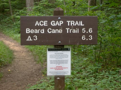
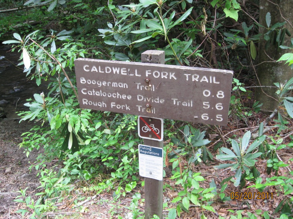
The Caldwell Fork Trail, located on the North Carolina side of the Great Smoky Mountains National Park, is a 6.3 mile hike from the junction of Rough Fork Trail to the intersection with Cataloochee Road. It’s an easier trail as it’s mostly downhill with meandering streams following along the path.

To access the trail via the Polls Gap Trailhead, take Heintooga Ridge Road north from the blue Ridge Parkway to Polls Gap. Then, follow the Rough Fork Trail 3.5 miles until you reach the Caldwell Fork Trail.

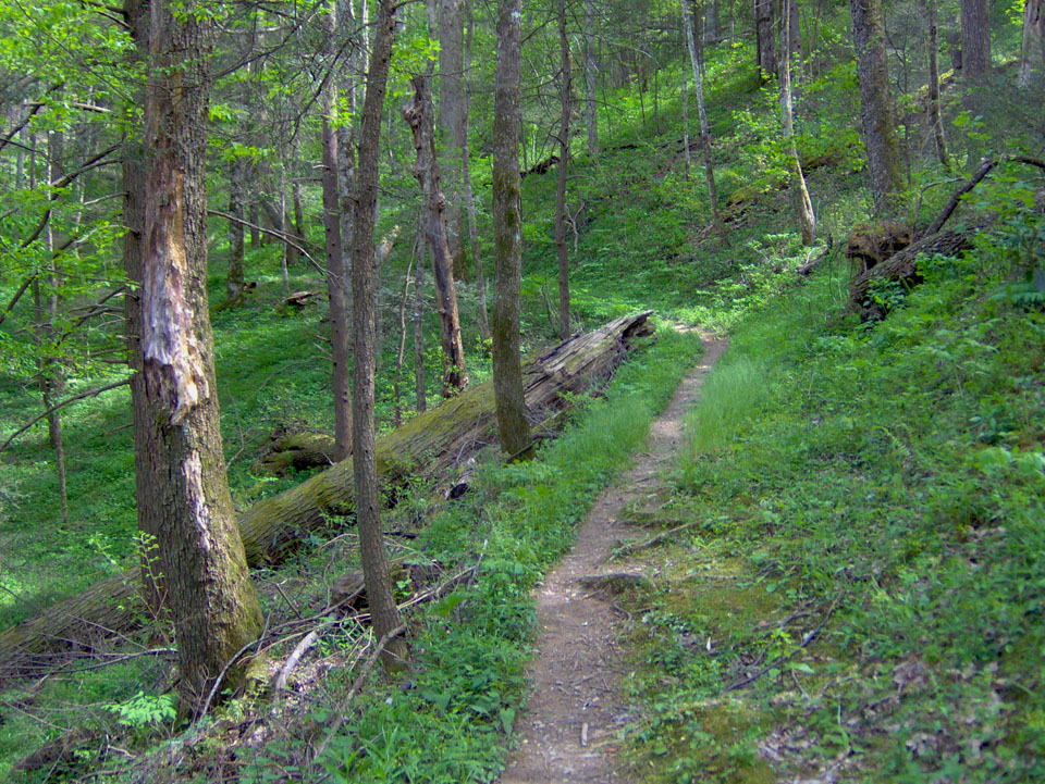
Caldwell Fork gets its name from the second group of settlers to come to the Cataloochee Valley. The trail itself is used by both hikers and horses so don’t be too surprised to find some sections muddier than others. The trail follows Caldwell Fork downstream throughout. You’ll also find beautiful American beech, red maple, and white oak, among others, on this hike.

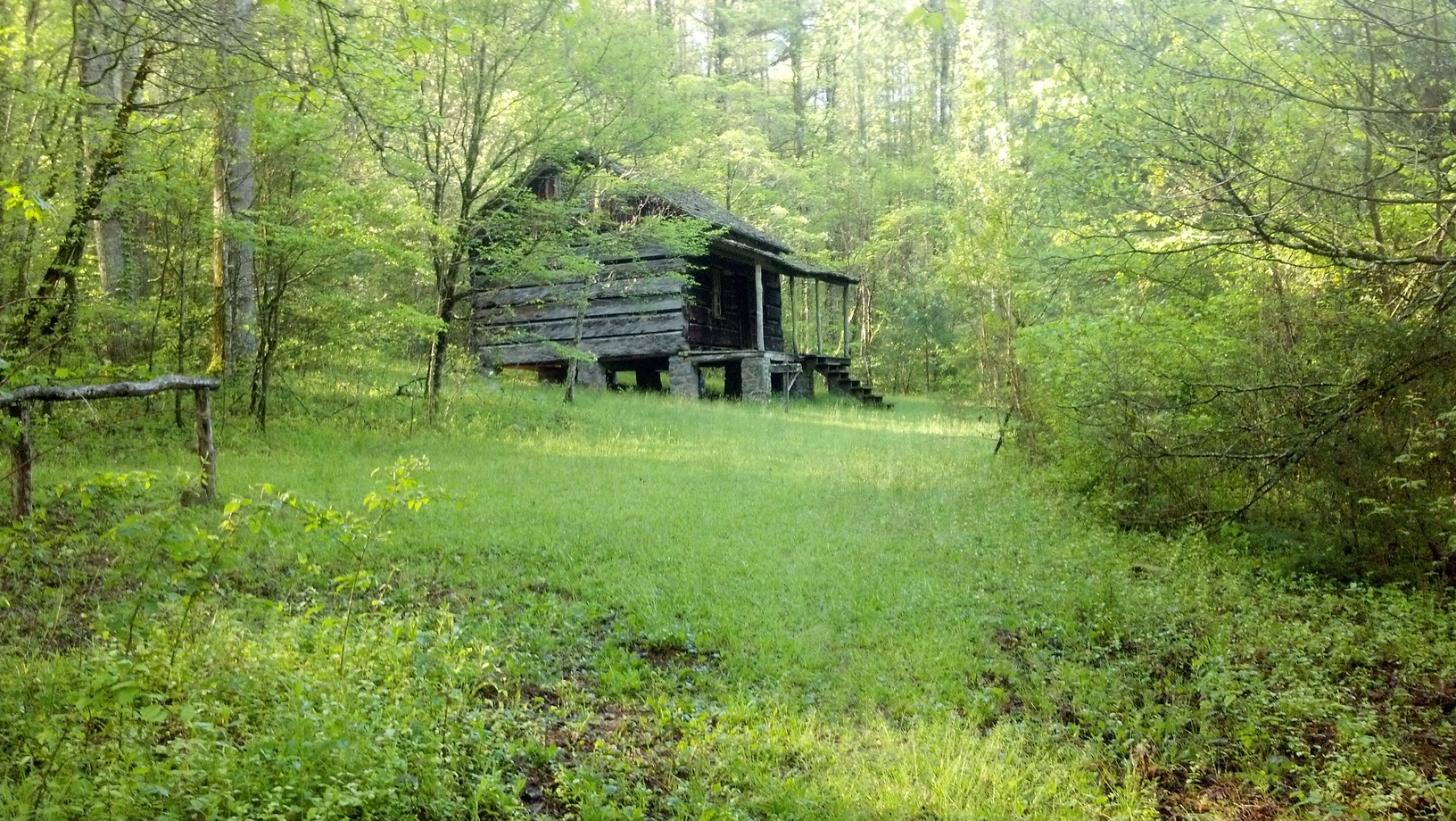
Hikers will pass old fence posts along the way and grassland, reminding them that there were once lush fields where cows grazed here before reaching backcountry campsite No. 41.

At 1.7 miles, the trail meets Hemphill Bald Trail junction. Continuing on, the trails descends through rhododendron and along the Caldwell Fork on the left. The Clontz Branch is passed without the use of a footbridge. When you’ve reached 3.1 miles into the hike, the junction with McKee Branch Trail appears.

Near this point is where the old Caldwell Fork School once stood. It was one of three community schools in the Cataloochee Valley which also included the schools in Big Cataloochee and Little Cataloochee. Most children during those times split their schooling and farm duties. It was said that school only lasted 5 months then.

The 3.6 mile mark is the first of two junctions with the Boogerman Trail. You’ll see a number of streams cross the trail following this intersection so be sure to watch out and get good footing before marching on. As you reach the end of the trail, be sure to notice Cataloochee Campground on your right as you finish up. It’s a great ending spot for a mildly challenging day hike.


Bone Valley Trail

The hike to Bone Valley Trail is a rather easy 1.8 miler and good one for beginning hikers or people just wanting to make an afternoon of it in the Great Smoky Mountains National Park.

The path starts at the Hazel Creek Trail, Campsite No. 83 to be specific, on the North Carolina side of the park. Getting there is the real fun part. The suggested way is to take a ferry across Fontana Lake to Proctor, then hike 5.3 miles up Hazel Creek to the actual Bone Valley Trail. Easier said than done, right? People say it’s worth the effort, we’ll let you decide.

As you start out from the trailhead, you’ll cross a wooden bridge over Bone Valley Creek before proceeding upstream. The trail follows an old railroad bed before you approach the first ford in the trail. It’s said that water is about knee deep during most seasons and when there hasn’t been a major weather happening.

White Walnut Cove is passed between the first and second fords. This place was at one time said to grow grapes which bears, others animals, as well as settlers vied for in the regions more primitive years.

Mill Creek is crossed after passing a former homestead and connecting farm. The plant Beebalm can be found growing here in June and July.

You come upon the Hall Cabin soon thereafter, following an appearance by the creek a fourth time. The cabin was originally located 200 feet from its current location. Not only is it on the Historic Register of Historic Places, it’s the most remote historic structure in the national park.

The Hall Cemetery is reached about 0.5 miles north of the Hall Cabin. This is unofficially the conclusion of the Bone Valley Trail, though many people sit around and peruse the area of the Hall Cemetery reflecting on the life and times of the area’s earliest settlers. It’s a quiet area and one of the more undisturbed spots in the park.

Gabes Mountain Trail

gmtsignHen Wallow Falls – a very popular and picturesque Smoky Mountain waterfall, is the destination of thousand of hikers every year which means trails like the Gabes Mountain Trail see a lot of action during the spring and summer months.

The 6.6 mile Gabes Mountain Trail is well worth the hike not only because of the falls, but for the old growth forest found surrounding the trail.

To reach the trailhead, from Interstate 40 in Tennessee take the Foothills Parkway to Cosby, TN. Take Tennessee Hwy. 32 at the Cosby Post Office, turn into the park and head toward the Cosby Campground. Park at the campground registration building and cross the road to meet the trail.

The trail is sheltered by mountains and giant trees of every species to its north. You’ll cross a number of small creeks by foot log on your way as well as a side trail back to the Cosby Campground. An old traffic loop that used to take visitors to Hen Wallow Falls is passed before you notice a number of old home sites along the trail on the other side of the loop. You can tell by the old chimneys.

Continuing on, the trail ascends and crosses another creek before rising past some large rocks and at mile 2.1 you come to an offshoot which takes one right down to the base of the falls. You’ve reached Hen Wallow Falls.

Goshen Prong Trail

goshenpringtrailLooking for a way to get to the Appalachian Trail and a little warm up as well? The Goshen Prong Trail in the Great Smoky Mountains is a great way to do just that and take in a number of beautiful mountain streams, as well as a cave, on the way.

In all, it’s a 7.6 mile journey from the Little River Trail to the Goshen Prong’s intersection with the AT. To get there, travel to the Elkmont Campground in Gatlinburg and park at the Little Rive trailhead. You’ll hike 3.7 miles up the Little River Trail till you come to its junction with the Goshen Prong Trail.

Starting out on the trail, you’ll notice a fairly wide trail and a rather easy climb. You’re hiking on old logging railroad beds that signals that the area was once logged heavily before being designated a park. Railroads were what got the logs out of the forests in those days. You’ll soon cross the Little River by way of an iron bridge.

Continuing on the trail, notice the ferns and mosses that now appear. You’ll also notice some old stone walls left over from the logging days. This is a great area to view a number of Smoky Mountain wildflowers during the spring and early summer.

You’ll see the creek cascade about a mile in on the trail, as well as two waterfalls before you start on the rocky, sometimes muddy, portion of the trail. That doesn’t that for long as an easier path comes into view among American beech trees. You’ll also notice a few fern fields along the trail – great places to sit, take a break and just admire the beauty of the Smokies. The path to backcountry campsite No. 23 is also passed along the trail. It’s one of the prettier backcountry sites, around 100 yards off the trail.

You’re now 4.4 miles from the intersection with the Appalachian Trail, traveling left and through a rhododendron thicket. You’ll soon drop down to Goshen Prong and a few pools, and continue on the trail crossing a few more creeks before reaching the cave.

The cave is on the left and can provide a bit of shelter from a rain cloud. However, try to keep away from such structures during a lightening storm.

Continuing on, you’ll cross a dry creek bed before hiking a rocky last mile of the trail. At the junction with the Appalachian Trail you’ll see a trail sign and the familiar white blazes marking the AT. Good luck on the trail!

Plants in the Smokies

The Great Smoky Mountains National Park is part of the International Biosphere Project.  It houses thousands of species of plants from mosses that only grow at the top of the mountains to trees that tower over the surrounding country side.  It is easy to see why this area was made a national park, the beauty is only compounded by the flora in the mountains.

During the spring and summer, the mountains are covered with colorful flowers and flowering bushes.  Most amazingly the rhododendrons that bloom in late June and early July color the mountains white and pink from the ridges to the valleys.  During the fall, as the leaves change color, the trees become the backdrop for many pictures and photographs.  The Leaf Season in the Smokies is one of the most popular times to take a drive through the Smokies.

Old Growth Forest – You will hear the term Old Growth Forest bandied about by Park Rangers and in hiking guides all the time when you are in the Smokies.  Old Growth Forests are those forests that have remained relatively untouched by man and in the Smokies that means they were untouched by the logging industry as well.  There are quite a few trails that will take you into old growth areas of the National Park.  The variety of trees, debris on the ground and the age of the trees varies greatly in these old growth areas but they are a lot of fun to walk through and enjoy areas that have been around for potentially hundreds of years.

Hemlocks – One of the most unique evergreen trees in the National Park are the hemlock groves that dot the mountains sides.  Beautiful, tall and green from top to bottom, the stands of hemlocks have had trouble in recent years due to the Hemlock Woolly Adelgid which is killing these trees by the dozen.

Ramps – This is one of those plants that few people know about but that the people of the mountains celebrate in festivals around the area.  From Waynesville, NC to Cosby, TN, the ramp is the subject of events held annually.  This cross between garlic and wild onion is something to taste.  It grows in the dark and moist areas of the mountains around and in the Great Smoky Mountains National Park.

Ginseng – You read that correctly, ginseng grows in the Smokies.  This is a subspecies of the Chinese variety but it does still have all the same properties – energy and memory restoration.  Ginseng has long been harvested in the areas around the park and sold to stores and processors.  The ginseng is an herb that has been used by Native American tribes and the European settlers that came later to the area.

Old Growth Forest

One of the natural wonders in the Smoky Mountains are the sections of Old Growth Forest.  Inside the 500,000+ acres of land lays 100,000 acres of old growth forest.

Old Growth Forest in the GSMNP is defined as those areas that were not harvested for lumber during the heavy times of the lumber industry before the National Park was founded.  The lumber industry before the park service came into play was clear cutting the mountains.  They were harvesting the trees as quickly as they could and leaving whole sides of the mountains bare.  This, of course, affected the ecosystem and the environment that the animals lived in.  With the lumber companies leaving, the new trees did spread and fill in those gaps that had been left behind and planting programs made sure that the trees came back as quickly as possible.  Fortunately there were still section of the forest that had been left alone by the lumber industry.

Old Growth ForestThese stands of old growth trees now tower over the trees that are next to them.  You can tell when you enter one of these areas due to the enormity of the trees and state of the forest floor around them.  Due to the fact that these areas have been left alone the ground cover is different in these areas, the canopy has an entirely different look and you can feel the age of the forest when you step into the shadows of these giant trees.

Most of the time to find these old growth areas you are going to have to hike for a while to get into the middle of these old growth areas.  One exception is the Chimney’s picnic area.  If you hike almost a mile up the Cove Hardwood Nature Trail, you will find yourself wAndering through a pristine section of old growth forest.  Towering hardwoods with their limbs intertwined to shade the floor of the forest and create a canopy that is unbelievable.  This short hike is the quickest way to get to an old growth forest section of the GSMNP.  Looking for a longer hike that might not be quite as populated:  Ramsey Cascade and the Albright Grove Loop Trail will lead you on a meandering trail through old growth sections that are as beautiful as they are hard to reach.

Next visit to the GSMNP, try to find an old growth forest in the Smokies.  Take a short hike and stand in the middle of trees that have been around for hundreds of years.  Get in the middle of the trees and lie down, looking up through the canopy to the sky.  Think of the changes that have happened around these groves of trees as they have survived through the years.  You are now a part of that old growth history, take a moment, enjoy it.

Jakes Creek Trail

Just outside Gatlinburg, Tn you’ll find the Jakes Creek Trail, a short hike in the Smokies that takes visitors into the national park and gives them the option of using one of the many backcountry camping sites located throughout the park. In all, it’s 3.3 mile hike from Jakes Creek Road to Jakes Gap.

To get to the trailhead, start out at the Sugarlands Visitors Center in Gatlinburg and take Little River Road traveling west. Take the turn into Elkmont at mile 4.9 then turn left toward the Jakes Creek Trail just before you reach campground. Keep right and park near the gate.

The Jakes Creek Trail follows the old railroad route that once ran up Jakes Creek built by the Little River Lumber Company. Once past the gate, the gravel road snakes through a forest of maples and tulip trees, as well as various other Smoky Mountain plants.

Once you’ve hiked 0.3 miles, you’ll notice that the Cucumber Gap Trail veers off to the left and at mile 0.4 the Meigs Mountain Trail takes a right. Hikers will cross Waterdog Branch 1.2 miles in by a foot log bridge. From there, the trail continues to rise before descending across Newt Prong. Be especially cautious on this portion of the trail during rainy weather.

Hikers will reach backcountry campsite No. 27 at 2.6 miles on the trail. It’s actually bordered by the trail on one side of the campsite, and the creek on the other side. This particular backcountry site gets quite a bit of use in the spring and summer months due to its close proximity to town. There’s enough room for eight campers and their horses here.

Continuing on the trail, you’ll notice that the creek soon disappears and you reach Jakes Gap at mile 3.3 – the conclusion of the Jakes Creek Trail. From here, there are two paths to choose from: the Panther Creek Trail which leads down to the Middle Prong Trail, or Miry Ridge which leads left and travels to its meeting with the Appalachian Trail. Enjoy the Smokies!

Cooper Road Trail

If you’re in the Cades Cove area and you’re looking for a good, all day hike; look no further than the Cooper Road Trail just off the Cades Cove Loop Road. It’s a 10.9 mile hike from the loop road, around 4.3 miles in, to the Abrams Creek campground.

A former Indian trail, Cooper Road, at one time, was the main access way into Cades Cove for early settlers venturing into the Smoky Mountain region for the first time.

cooper road trailIt’s an easy hike going in as maples, oaks, and pine trees are prevalent before reaching a small sign for the Wet Bottom Trail – a connector trail if you’d like to go back to the Elijah Oliver Place.

Continuing straight, the trail soon rises over a few ridges and a creek, then descends into a ravine. More ridges appear and the trail continues higher and higher on a rockier path. Two miles into the hike, the trail begins to cut back and forth above a creek. This is a great area to gaze at some beautiful spring wildfowers.

You’ll come to the junction with the Hatcher Mountain Trail and Little Bottoms Trail at mile 5.7. The Cooper Road Trail continues straight at this intersection through more maples and oaks. Once you’ve hiked 7.4 miles, you’ll notice 3 large rocks that mark the intersection with the Cane Creek Trail.

Hikers moving along will climb left to the junction with Goldmine Road. Here, you’re at 1750 feet and it’s downhill for most of the way, with one exception up a creek.

During your gradual descent, you’ll notice a scraggly wooded area, drop into a ravine, and cross yet another creek. More water crossings are a sign of Kingfisher Creek’s tributaries before coming to backcountry campsite No. 1 on the left. Ten people can camp here and Kingfisher Creek runs behind the site.

The Little Bottoms Trail junction is reached at mile 9.6 and leads left to Abrams Falls in a little over 4 miles. Abrams Creek Campground is seen at mile 10.5 and the ranger station is just a bit further.

Gatlinburg Trail

  • 1.9 miles in length
  • Starting Points – Sugarlands Visitors Center or River Road in Gatlinburg near traffic light 10
  • Points of Interest – Footbridge over the West Prong of the Little Pigeon River & CCC homesites
  • Difficulty – 1

Gatlinburg TrailAre you looking for an easy trail?  Are you wanting to hike but not end up passed out on the side of the mountain because the elevation was just too much to take?  Then the Gatlinburg Trail might be your best option.  Starting from either Gatlinburg or from the Sugarlands Visitors Center, you are looking at an almost 2 mile hike with very little elevation climb and a beautiful scenery as you wind through the lower altitudes of the Smokies along the Little Pigeon River.

I like to start this hike from the Gatlinburg end if the trail.  Park in Gatlinburg along River Road or arrive early and you might can park across from the trailhead itself.  Hop out of the car and start on the trail.  You start right next to the river – and if you are just looking to go wading, this is the spot.  Within the first half a mile of the trail there are several places that you can walk right down to the river.  Also, in the first half you will come to the first big highlight on this trail – the footbridge.

Gatlinburg TrailThe footbridge over the Little Pigeon River is THE reason to hike this trail, and it is also part of the reason that most people start from the Gatlinburg end of the trail.  The footbridge allows you to see upstream and downstream on the Little Pigeon.  It is a perfect place for a family photo.  Also, right past the bridge there is a path that leads down under the bridge for a great opportunity to play in the water.  When you are ready to continue your hike, jump out of the water and head back up to the bridge, hiking away from Gatlinburg into the mountains.

Another half mile of hiking, about halfway down the trail, you will come to the next big highlight.  You will have gained some elevation slowly over the course of the trail and on your right (again if you are headed toward Sugarlands) you will see a chimney.  This chimney marks one of the CCC Camps that helped to make this trail into the wilderness.  The CCC or Civilian Conservation Corps were conscientious objectors to World War II that were used to help establish the trails and facilities in the National Park.  Around the park you will find relics, left over from where these people lived and worked in the GSMNP.

Gatlinburg TrailThere is one thing to remember when you are hiking the Gatlinburg Trail, it is a one way trail.  This is not a loop that will bring you back to the place you started so you will have to hike the 2 miles back to the trailhead you started from unless you have dropped a car off at the other end of the trail.  That means that you are looking at around 4 miles of hiking inside of almost 2 if you have to hike back.  This is just something to keep in mind for any of the trails in the park that are not loop trails.

Ace Gap Trail

Looking for a great hike where you can see the Smoky Mountain fall foliage in all its glory? Try the Ace Gap Trail which travels 5.6 miles from Rich Mountain Road to Beard Cane Trail.

The trailhead is close to Cades Cove which is a good thing for all those visitors who come to the park either looking for the entrance or Cades Cove – two of the more known locales of the Great Smoky Mountains National Park. You can access Rich Mountain Road from the Cades Cove Loop Road.

At the trailhead along Rich Mountain Road, hikers will notice a large sinkhole – evidence of the abundance of limestone in the area. Once you start, you’ll notice a side trail to the Bull Cave. Only hikers with special permits and equipment can enter the Bull Cave as it descends 420 feet. It was given the name Bull Cave as Rich Mountain Road was at one time a cattle passage and legend has it a bull fell into the cave, thus the Bull Cave.

Large growth oak trees align the start of the Ace Gap Trail, which is considered one of the park’s easier trail as it runs nearly level throughout the 5.6 miles. If you look closely at the white pines on the left of the trail you’ll notice the lightning scar on one that runs the length of its trunk.

Hikers will reach Kelly Gap at 2.3 miles. Further hiking brings you along a ridge line before you reach the Beard Cane Trail. In May, numerous Pink Lady’s Slippers give the higher a “How do you do?” upon reaching the Beard Cane Trailhead.

You’ll be able to distinctly tell when you’ve reached Ace Gap at 4.8 miles by the old railroad bed that crosses the trail. This was the property of the Little River Lumber Company during its heyday. It is said that Ace Gap gets its name from the timbermen who gathered to play cards at this spot during their break.