Eagle Creek Trail

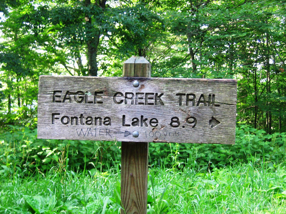
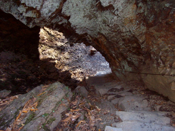
The Eagle Creek Trail in the Great Smoky Mountains is an 8.9 miler with various streams crossing the trail throughout. Starting on the North Carolina side of the Smokies, the trail begins at the junction of the Lakeshore Trail – 6.1 miles northeast of Fontana Dam. To reach that point, you’ll have to take a boat across Fontana Lake to backcountry campsite No. 90. In other words, you’ve got to really want to hike the Eagle Creek Trail because it takes some maneuvering to get there.

eaglecreektrail1Eagle Creek has been used for years by various people to make a living, as well as for travel purposes. Today, the TVA harnesses its water for electricity. Hiking the Eagle Creek Trail starts out at the base of the creek. It’s a strenuous, challenging hike so be prepared and wear good shoes or boots.

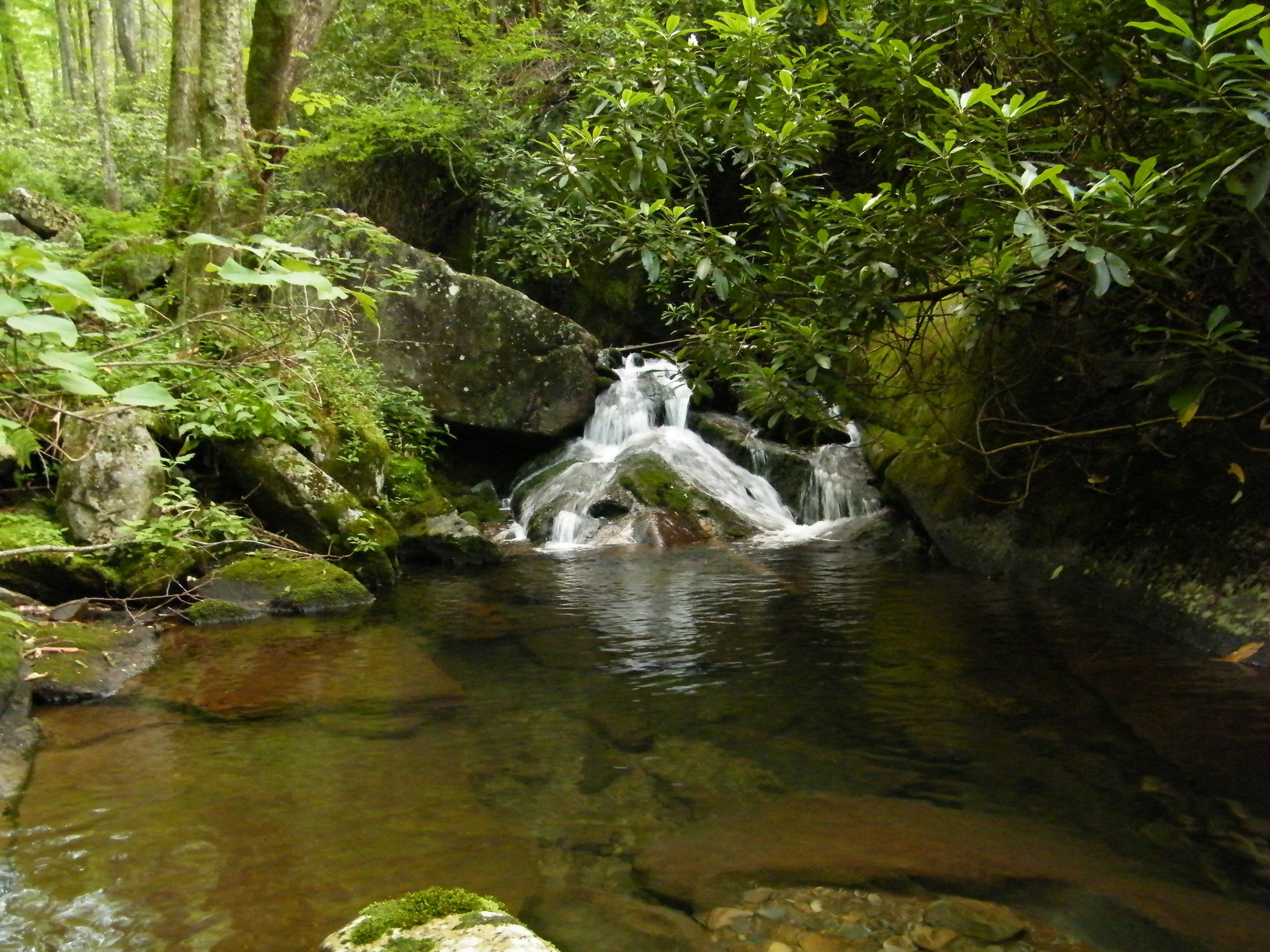
At 0.5 miles past campsite No. 90, the trail crosses the stream by way of a foot log with a handrail. It’s a pretty aggressive stream at this point so proceed with caution when crossing the foot bridge.

The junction with Pinnacle Creek is reached at 0.7 miles on the trail. Eagle Creek is crossed again in about a quarter mile, sans a foot bridge. You’ll be tasked with crossing the creek at least 15 miles within the first 4.6 miles so be prepared and make sure to wear the appropriate gear. Sometimes the water levels may not allow you to go on. This trail depends a lot on the recent weather.

Backcountry campsite No. 89 is passed at mile 1.6 and can hold as many as 6 tents. You’ll rock hop Ekaneetlee Creek following the campsite and cross Eagle Creek again soon thereafter. And at the 2.6 mile mark, you’ll reach backcountry campsite No. 96, which is basically an island and can hold 4 tents. However, if you want to use the bathroom, you’ll have to ford the creek back to the other side as the island does not meet backcountry regulations when it comes to bathroom use.

More stream crossings are met 4 miles in. You’re beginning to get the picture when it comes to the large amounts of tributaries that crisscross the trail. Good shoes are imperative. Backcountry campsite No. 97 is passed before reaching Spence Field. The washtub at the campsite is to be left untouched, but feel free to imagine what early settlers may have used it, or in fact lived in the area.

Continuing along the shores of Eagle Creek, the trail begins to climb and get steeper. Gunna Creek – a major tributary of Eagle Creek is reached as you climb the mountain. It’s rough descent down the mountain in no way reminds the hiker of Eagle Creek.

You’ll cross Gunna Creek for the first time at mile 6.2 by way of a somewhat difficult rock hop. There is no fishing beyond this point either as the park looks to protect such species as the brook trout.

As you hike up and up, Spence Cabin Branch follows the trail. You won’t cross it until the path levels. On up the mountain you’ll come to Spence Field Shelter where hikers can find shelter and bathrooms. If you plan to stay here, be sure you make reservations beforehand. Spence Field is east only 0.1 miles. If you want a great view of Cades Cove, walk on over an admire the beauty of the Smokies. Enjoy it, you’ve hiked a very challenging trail and should be proud of your perseverance.

Forney Creek Trail

The Forney Ridge Trail joins the Forney Creek Trail on a 7.6 mile descent from Clingman’s Dome to the Jonas Creek Trail intersection. While few might choose this as an out-and-back, it’s part of a popular 20.5 mile backcountry loop that continues up to Silers Bald on the Appalachian Trail and back to Clingman’s Dome.

forneycreektrail2No matter your route, the Forney Creek Trail is compelling for its passage through several distinct ecotones, a stop at Forney Creek Cascade, light crowds, and several unaided, potentially challenging creek crossings:

Begin on the Forney Ridge Trail, which drops steeply past the Clingman’s Dome Bypass Trail through dense bands of Fraser fir and red spruce. Though swaths of forest exhibit extensive beetle damage, the trail corridor itself is healthy and verdant.

Forney Ridge drops in rugged stages to the Forney Creek Trail, which narrows on a variously steep and sloppy descent. Notable along the way are open grassy hillsides – a relative rarity in the Park – which are good places to find turkey and bear.

The trail reaches the top of Forney Creek and turns down beside it, transitioning from spruce and fir into an upper-hardwood forest. Birch and rhododendron appear as you head downstream to the 1st of two spurs for Backcountry Campsite #68.

This is potentially confusing, as the falls and 2nd site are still .4 miles away, and the two are not depicted separately on most maps.

Continue through a steep hairpin turn down to the second site #68 at the base of Forney Creek Cascade. This long, two-tier fall slides down wide rock slabs into a narrow pool along the creek.

Grades moderate past the falls across a tributary, the first of many wet encounters. Hardwoods emerge in greater numbers on a steady, if uneventful descent along dry southwest-facing slopes.

The creek is audible but mostly concealed until reaching the first major crossing at 4.95 miles. This scenic area is highlighted by a tumbling tributary and several cascades upstream.

The trail continues above and away from the creek into the heart of a northern hardwood forest. Rhododendron envelops portions of the trail while vines drape from towering maple, beech, and poplar. The understory is notably lush and diverse at these lower, wetter elevations.

You’ll reach a second major crossing at 6.0 miles to Backcountry Campsite #69, which is unceremoniously located right along the trail.

Travel levels considerably to consecutive crossings at 6.25 miles, 6.6 miles, and 7.0 miles. Concentration and fatigue management are key on these more voluminous fords.

The Forney Creek Trail meets the Jonas Creek Trail at a log bridge near the creeks’ confluence. Whether continuing on a loop or returning the way you came, a minimum 3,800′ net climb awaits back to Clingman’s Dome.

Rhododendron

The hillsides, valleys and peaks of the Smoky Mountains are covered with color in the late spring and early summer.  As you drive across the mountains on Newfound Gap Road you will notice that the brilliant swatches of white and pink seem to be almost endless.  The main source of these colors are the vast quantities of rhododendrons that cover the landscape.

The Rhododendron in the Smoky Mountains fall to two types:  Rosebay and Catawba.  Certainly there are several forms of Azalea that fall into the same category but that is for another discussion.  The Rosebay rhododendron is the source for the whitish flashes of color that you find in the lower elevations of the park, up to about 5,000 feet.  The Catawba rhododendron is the source of the pinkish swatches of color that cover the high elevations.  Throughout most of the year, both types of rhododendrons are dark green with oily looking leaves.  Rhododendrons don’t like lots of sun and tend to be in the shady areas of the park and along the streams and creeks.  All of a sudden in late June and early July, the buds on these plants burst forth and there is color everywhere.  People flock to the Smokies at these times to take in the color and to photograph these majestic plants.

Where can you see the rhododendrons the best:

  • Roan Mountain – This is by far the best place to see lots of Catawba rhododendrons.  There is a rhododendron garden at the top of Roan Mountain that comes alive when the Catawbas are blooming.  You walk through a sea of pink that seems to stretch from one side of the horizon to the other.
  • Newfound Gap Road – As you travel along Newfound Gap Road from Sugarlands to Oconaluftee (or vice-versa) you will watch the rhododendrons change from white to pink to white as you start up the mountain and then come back down.

One thing to remember about rhododendrons is that each bush does not bloom every year.  So a clump that you were particularly taken with last year may not bloom at all this year.  Search out clumps of them in the park and take some pictures, use them as a backdrop for your family portraits or maybe even plop down and have a picnic at the side of a stream near a rhododendron in full bloom.  Let the whites and the pinks roll over you.  Get set for summer with the rhododendrons in bloom.

Baxter Creek Trail

Looking for a Smoky Mountain trail the really gets your heart and leg muscles going? Look no further than the Baxter Creek Trail – a 6.1 mile rocky trail that goes no where but up. Get your good fitting boots ready and stretch those quads because this trail will make a man, or woman, out of you.

The trail starts out at the Big Creek Picnic area at the Big Creek Campground in Newport, TN and travels upward to the junction of the Mount Sterling Trail and Campsite #38. A handful of logging companies used the land over the course of a century to 1930s with various degrees of success. Still, the mountain’s steep grade seemed to have its way with most as each eventually abandoned its efforts.

The trail starts off at the Big Creek Picnic Area before crossing a metal bridge over Big Creek. From there, the trail begins to rise and you’ll notice a large island in Big Creek to the right. You’ll encounter number tree and wildflower species along the trail from toothwort to the American beech before moving through forests of hickory, maple, and dogwood. A side trail leads to a large stone chimney at 0.3 miles.

You’ll hear Baxter Creek before coming to a large Eastern hemlock with a number of branches on its lower trunk. The trail is becoming narrower, rockier, steeper, and at times more hazardous at this point as you approach Baxter Creek again. This is where the climbing really begins and doesn’t end till you reach the fire tower. Eventually you’ll reach a small ridge overlooking Big Creek Valley where you can see Mount Cammerer.

Getting Ready to Hike

So you have decided to go hiking for the first time in the Smokies.  Congratulations!  Now, next comes what do you need to take with you when you start your first hike in the Smokies?

gettingreadytohike1We are going to start with the idea that you are planning a day long hike.  Not a simple jaunt into the woods for a few hours but a trip down one of the trails that might take you most of the day to complete.  In fact, let us assume that your hike is going to be around 8 miles, round trip, and you are giving yourself 8 hours to complete it (more on this later).

Your Feet
One of the most important things you can do, to make sure that you have a fun day hiking, is make sure that you have good shoes to protect your feet.  This is vital, if you are a hiker, you know that your feet are going to keep you going.  If you are not a hiker, you will soon learn that the proper foot wear is going to make your trek into the woods a lot more enjoyable.  If you are going to be climbing in elevation, crossing rough terrain or if you are going to have to go along a trail that is not as cared for as some, get a pair of boots.  Keep your ankles healthy, keep the soles of your feet happy and your feet will treat you well in return.

Food and Water
You are going to be on the trail for 8 hours.  You will need water, you will need food.  Pack something easy to eat while you are on the trail.  Sandwiches, peanut butter, trail mix (pun intended), anything easy to eat.  You also want to take food items that have plenty of protein and carbs.  You will need the energy that these foods provide to get you up and down the trail.  Water is also a necessity.  Take enough to get you to the destination on the trail and back.  You will feel very bad having consumed all of your water on the way in and not having any to drink on the way back to the trailhead.  And remember, as with all things in the Great Smoky Mountains National Park “Leave No Trace” – pack out what you take in.

Elevation
If you are not used to the elevation, keep in mind that the elevation change is going to effect you.  The air gets thinner the more elevation you gain and the harder it is going to be to get the air you need to finish your hike.  Take your time and plan for short breaks to catch your breath.  If you find that you are ‘sucking wind,’ don’t get alarmed – this is normal.

Time
Plan for plenty of time on the trail.  When you talk to a Park Ranger, they are going to tell you to plan to average 1 mile each hour.  Certainly experienced hikers will realize that they can average a much quicker pace but if this is your first long hike, 1 mile an hour is about right.  Plan ahead.  Don’t assume because it is an 8 mile round trip that you are going to make the journey in 3 hours.  Give yourself plenty of time.

This is by no means an exhaustive list of things you need when you go hiking but it is a place to start.  Stop by one of the outfitters in the area or the ranger stations and check with them. See what they recommend for the hike you are taking.

Bent Creek Golf Course

If you are wanting to get away from the hustle and bustle of the big city and do some golfing, then Bent Creek Golf Course is the golf course for you.  Beautiful and lush, surrounded by the Smoky Mountains and ready to play, this year round course is challenging yet forgiving – providing a great experience for the expert and novice alike.

Bent Creek Golf Course was designed by Gary Player.  Player, a three time Masters and British Open winner, wanted Bent Creek to match the contours and beauty of the Smokies.  He fell in love with the surroundings and wanted a course that made people feel the relaxation of the mountains and a course that had the mountains imprinted on its very design.  The grass and the upkeep of this course keep it open all year round and though playing in winter is a rather cold prospect, it is s still a joy to walk in the shadows of the mountains.  Playing Bent Creek means you can look across the road and see the Great Smoky Mountains National Park from each and every hole.

Fees and Information

  • Open 7 Days a Week
  • $35 Winter Rates
  • $50 for the full course
  • $27.50 for 9-Holes

For more information and to make reservations for a tee time, call the pro shop at 865-436-3947.

Bent Creek is located outside of Gatlinburg proper.  In Gatlinburg go to traffic light 3 and make the turn onto East Parkway / Hwy 321.  You are now on the road that heads to Cosby, TN.  You are going to stay on Hwy 321 for about 11 miles, roughly half the distance to Cosby.  Bent Creek will be on the left hand side of the road.  But, if you are planning to do a lot of golfing while you are in town, Bent Creek even has cabins and condos for rent right beside the golf course itself.  If you are in town for the purpose of golfing in the Smokies, then Bent Creek ad the lodging provided by Bent Creek Golf Village is perfect.

Take in the Smokies from the Linx.  Play some golf in the shadows of the Smokies.  Make Bent Creek Golf Course a stop on your list of things to do.  Play 18 holes and spend time with friends and family in the great outdoors.

Bent Creek Golf Course
3919 East Parkway
Gatlinburg, TN
865-436-3947
http://www.bentcreekgolfcourse.com

Alum Bluff Caves

From the Sugarlands Visitor Center, drive 8.6 miles east on Newfound Gap Road. There you will find two Alum Cave Bluffparking areas, where a gravel path leads to The Grassy Patch and the beginning of a 2.3 mile hike to Alum Cave Bluff.

Summary: This moderately difficult hike is 4.6 miles round-trip or 5.1 miles on to LeConte Lodge. The round-trip to the cave bluff takes about 2 and 1/2 hours, but allow about 3 and 1/2 hours to LeConte Lodge. The Alum Cave Trail is the most popular and well-known route to Mount Le Conte.

Elevation: You gain 2600 feet on the way to 6400 feet.

Features: Arch Rock, 1993 summer storm damage, Inspiration Point, Alum Cave Bluff

Mother Nature’s majesty and power are clearly demonstrated in this 4.6 mile (round-trip) hike. The views are great, particularly if you go on to LeConte Lodge and Cliff Tops, and the trail is not too difficult–even for children. To demonstrate, I recall an early visit (I was much younger and more fit) when I carried my sleeping daughter on my shoulder for the majority of the first half of the hike.

You’ll begin this hike at the Grassy Patch just off the parking area. Shortly after entering the forest, you will parallel the Alum Cave Creek for approximately a mile and then follow Styx Branch, a main tributary of Alum Cave Creek. A few hundred yards beyond this point, you’ll see the boulder and log remains of a 1993 flash flood and landslide on your left. A heavy thunderstorm dumped several inches of rain, with a force so great that huge boulders were exposed and tossed–its path is clear to the hiker and will remain so for years. At mile 1.5 you come to Arch Rock, where a set of stone stairs aids your passage through one of the few natural arches inside the park. At the 1.8 mile mark you will come upon Inspiration Point, affording the first panoramic view of the area. Thereafter, you’ll pass through an area of low shrubs, and shortly thereafter arrive at Alum Cave Bluff (mile 2.3). Alum Cave is not what the name implies. Its not a cave–rather it’s a jutting ledge of black slate, forming out over the trail to give the impression of a cave. The name Alum Cave comes from the deposits of alum found along the “cave” walls.

For the hardy souls who will continue on to LeConte Lodge, the trail curves up and around the bluff and begins following the ridge that forms the southern flank of Mount Le Conte.

Two hundred yards from it’s finish at Le Conte Lodge, the trail is joined from the left by the Rainbow Falls Trail. Le Conte Lodge consists of several wood-shingled cabins, two lodges, and a dining room. There is no electricity and water is pumped into holding tanks from a spring. The lodge uses llamas to haul in supplies (that’s a story for a future issue!). Reservations can be made at LeConte Lodge by calling (423) 429-5704.

Above the lodge you’ll find Cliff Top, one of the best vantage points in the Smokies–when the view is not obscured by misty clouds.

If your trek to Alum Cave Bluff is a day-hike, take a knapsack and carry a few extra items. Include some bottled water and a snack. Never drink the water from a Park stream without boiling it first. Though the streams in the park are invitingly cool and deceptively clear, they contain bacteria that can wreck your trip and a substantial period thereafter, if you succumb to the temptation to drink from them. You might even include a camera in your knapsack too. If you are making an overnight trip to LeConte Lodge, you’ll be carrying a backpack, and we assume here that you have included all the necessary items and arranged for the required reservation at the lodge. A backcountry permit is required for overnight stays in the backcountry. Certain campsites are reserved in advance. Permits are available at visitors centers or by calling (865) 436-1231.

Laurel Falls Trail

  • Laurel Falls Trail4 miles in length – 1.3 miles to Laurel Falls
  • Starting Points – On Little River Road between Sugarlands Visitors Center and Elkmont
  • Points of Interest – Laurel Falls
  • Difficulty – 1 to the falls – 3 to the finish of the trail

This might be the most popular and most hiked trail in the national park.  The first section, the 1.3 miles to Laurel Falls is paved and wide.  This trail was cut in by the Civilian Conservation Corps in 1935 and since that time and the opening of the park, people have flocked to it.  Now, that being said, the first part of the trail, the section that leads to the falls, is the popular part.  After that point, the trail gets a lot steeper and rougher to hike.

When you hike the first 1.3 miles to the falls you will be greeted by a wonderful waterfall that is highly photographable and beautiful. The falls plunges 75 feet from its apex.  There is a new cement bridge that allows you to safely cross to the other side of the falls and then down to the base where you can splash in the crisp mountain water, picnic or just take advantage of a place to rest before you start up the trail again.

Laurel Falls TrailAfter you have had a rest at the base of the falls, you will start your climb to the end of the trail.  The paving stops at this point and the trail narrows so that you are going to need to walk single file most of the time.  The final 2.7 miles climbs from around 2600 feet to almost 4000 feet.  The trail becomes a lot more strenuous and you will find the need to take breaks from time to time.  There is one good thing about the rougher terrain though – the fires in the park and logging didn’t reach this area.  You will hike through Old Growth Forest!  You will see some of the largest trees in the national park.  If you are up for the hike, make sure to hike the full 4 miles.

If you are planning on hiking the whole trail you are going to want to get an early start and due to the parking area and the popularity of this trail, you will need to get there early to find a place to park.  Especially on the weekends, parking is a premium at Laurel Falls.  Also, keep in mind this is not a loop trail.  So the full length of the trail is 8 miles, not just 4, you have to hike back out.


Park Rangers

Park RangerIn the Great Smoky Mountains National Park, the Park Rangers work as protectors of the public and the resources that are in the National Park.  They are the official managers of the park and act not only as patrolmen, making sure the public is safe and that the visitors to the park are acting in accordance with all rules and regulations, but they are also the curators of the park itself – making sure the historic structures, flora, fauna and recreational sites are being well cared for.

One of the duties of the Park Ranger in the National Park is to supervise the people that visit the park itself.  They act as traffic cop, enforcing the rules of the road, speed limits and the restriction of commercial traffic from the park roads.  They are also there to protect the public from itself.  Making sure that people who visit the areas of the park abide by the regulations, as far as wildlife and the environment go.  When visitors get over zealous and approach too close to the wildlife the Park Ranger is the person that steps in to make sure that both the guest in the park and the wildlife remain safe.

It is also the Park Ranger that acts as curator for the natural resources in the GSMNP.  They maintain the historic buildings in places like Cades Cove and Cataloochee.  They help maintain the trails that people hike in the park.  The Park Ranger is also the custodian of the wildlife and vegetation in the park.  The Rangers help with the prescribed burns that happen in the park from time to time.  The Park Rangers teach the visitor about fire safety, hiking safety and how to “leave no trace” while they hike in the park.  These duties are the most important that the Park Rangers perform.  They are able to teach the guests in the park how they can help care for the environment and the GSMNP.

The Park Rangers carry the authority of the Park Service with them at all times.  They are both guest relations and law enforcement and they are to be respected and admired.  If you see a Park Ranger, walk up and offer them your hand, tell them thank you for their service, tell them you appreciate the job that the perform.  Basically just tell them thank you. Follow their rules, help them by being respectful of the natural and national resources that they have chosen to protect and remember that the activities that you take advantage of in the Smokies are due to the fact that they have chosen to serve the public.

Shuckstack Tower

Length: 6.8 miles roundtrip
Difficulty: Medium to Strenuous
Highlights: Excellent views of Fontana Lake and the Smokies
Caution: Steep terrain can be slick in snow or rain, or on fallen leaves
Note: Best hiked on a clear day to enjoy the view.
Directions: Shuckstack is on the North Carolina side of the Park. From Bryson, take NC 28 to Fontana Dam. Start your hike from the north side of the dam.

Hike to Shuckstack Tower

The historic fire towers of the Great Smoky Mountains National Park were once used to gain a bird’s eye view of the mountains in order to spot forest fires. Though many of the towers were removed as more modern methods for fire detection were developed, Shuckstack and three other towers remain. These out of the way destinations are well worth the extra effort, and the vistas they provide are by far better than any view available from any roadside overlook.

Located on Twentymile ridge, the Shuckstack fire tower is just a tenth of a mile from the Appalachian Trail and a mere 3.4 miles from the road. The quickest and easiest way to access the tower is to begin on the north side of Fontana Dam, which is on the North Carolina side of the Park. Please note that the dam is under renovation at this time, and vehicles are prohibited from crossing the dam. Foot traffic across the dam is allowed, however. The section of road you have to walk to reach the trailhead is nice and level, but it will add a little over a mile to the roundtrip distance of the hike.

As you cross the dam, scan the mountains to the north and you’ll be able to make out the tower in the distance. Fontana Dam is a monumental piece of engineering, and is the largest dam east of the Rocky Mountains; the lake is over 400 feet deep at full pool! Continue across the dam, take a right, and you’ll find yourself at the Appalachian Trail in a little over half a mile. Now begins the fairly challenging ascent of Twentymile Ridge. The trail is uphill nearly from the start – just remember that slow and steady wins the race. Take breaks as you need them, and you’ll find that the three and a half miles to the tower isn’t as daunting as most make it out to be. You’ll notice that there are plenty of short but flat stretches on the trail that allow you to catch your breath, and plenty of fallen logs and rocks to sit on and rest along the way. Though it’s often difficult to gauge your progress, you will have glimpses of the tower from time to time (especially in winter months). At around two and a half miles the trail will level considerably, and the walking will be easy for the next half mile or so. Then, about a quarter of a mile from the tower you’ll encounter your steepest climb (it’s mercifully short, though). Once on Twentymile Ridge, you’ll encounter a three-way intersection. The AT is marked with simple white line blazed on the trees, while the path the tower is marked with a white “T”. From here, the tower is just a tenth of a mile.

The Shuckstack fire tower is actually a small wood and metal building perched atop a winding eighty-foot staircase. You’ll no doubt see that the view from the rocks at the bottom of the fire tower is incredible, but the view from the tower is much better. As you begin to climb the tower, you’ll notice that it moves ever so slightly, but don’t be alarmed. Wind continuously blows acrossView of Fontana Lake from Shuckstack Tower 
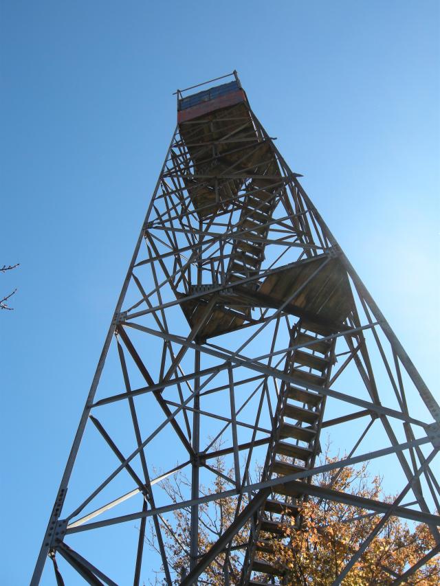
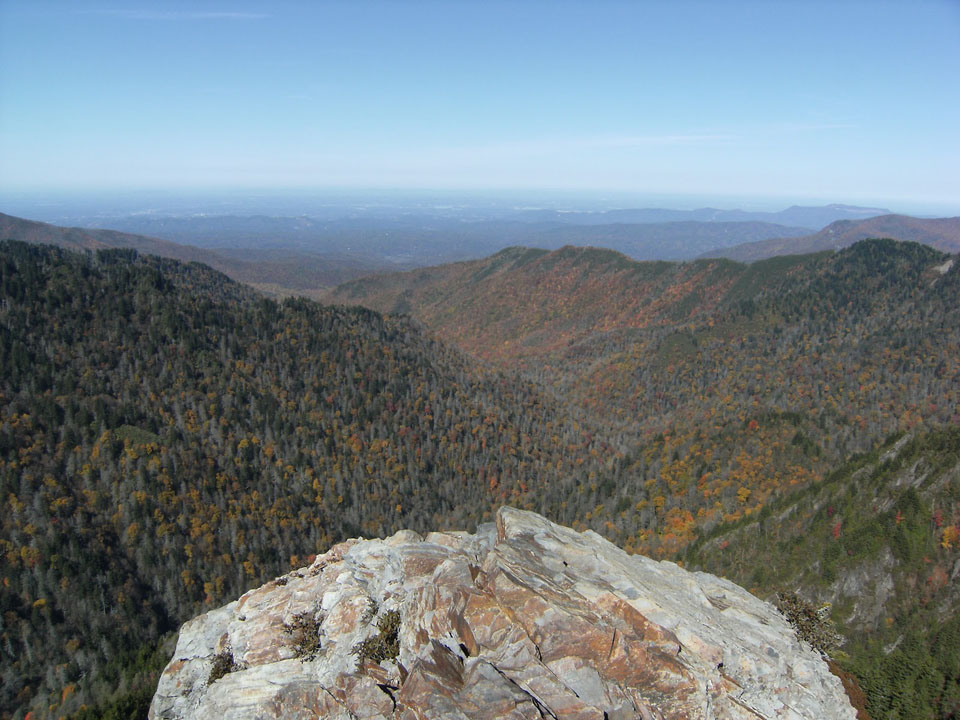
this ridge, and the tower is made to give a little. From the top of the tower, you’ll be awarded a spectacular 360-degree view, with mountains in all directions. The Unicoi Mountains can be seen to the west, the Snowbird and Nantahala Mountains to the south, the Blue Ridge Mountains to the southeast, and the Smokies to the east and north. Remember looking up at the tower as you walked across Fontana Dam? From this vantage point, you’ll be able to make out the dam and all of the land you covered on your way to the tower. You’ve covered about three and a half miles and climbed over two thousand feet. It’s a rewarding feeling indeed. To return to your car, simply descend from the tower and return the way you came.

If your trek to Shuckstack is a day-hike, take a knapsack and carry a few extra items. Include some bottled water and a snack. Never drink the water from a Park stream without boiling it first. Though the streams in the park are invitingly cool and deceptively clear, they contain bacteria that can wreck your trip and a substantial period thereafter, if you succumb to the temptation to drink from them. You might even include a camera in your knapsack too. A backcountry permit is required for overnight stays in the backcountry. Certain campsites are reserved in advance. Permits are available at visitors centers or by calling (865) 436-1231.