Go-Kart Tracks

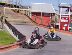
Who doesn’t like to ride go-karts.  For small children this might be their introduction to driving.  For young adults this is the height of competition, racing around the track at breakneck speeds trying to see who can cross the finish line first.  For the older ‘kids’ in the group this is a chance to be a kid again.  To climb into the go-kart and race your friends, no matter how old they might be or to chase your kids around the track , this is the thrill of racing a go-kart, this is the reason that you will find go-kart racks and other family adventure venues all over the map in the Smoky Mountain area.

You will also find that there are several different types of tracks in the Smokies:

  • Slick Track – Slick tires on a track that has been oiled.  You will find yourself slipping and sliding around every turn.  Not for the timid, the slick track is harder to find then it used to be but a lot of fun.
  • Wooden Track – These became big in the Smokies in the early 2000s.  Wooden tracks allowed the owners of these tracks to take the go-kart tracks ‘up’ instead of out.  Climbing around a tight circle before a steep descent is the norm with these tracks.
  • Kiddie Tracks – Designed for those younger kids in mind.  You can probably find a track in town that will let all but your youngest children drive around and around and around.
  • 3/8 Scale Tracks – The fastest tracks that you will find.  These are almost half scale cars that go FAST.

The TrackThe Track – This is one of the biggest family fun parks and go-kart locations in Pigeon Forge.  Along with the go-karts you can play in the bumper boats, bungee jump, ride the Skyflyer or play in the Kid’s Country.

NASCAR Speedpark – This might be the premier place for go-karting in the Smokies.  With a 3/8 scale track that gets you as close to NASCAR action as you are apt to find.

Cherokee Fun ParkCherokee Fun Park – Located in beautiful downtown Cherokee, NC, this fun park has a little bit of everything.  Go-karts, an arcade, rides and more.  Walk around downtown Cherokee and then spend a little time in the fun loving atmosphere of the Cherokee Fun Park.

Forney Ridge Trail

One of the more traversed areas in the Smoky Mountains is Andrews Bald, and rightly so, it’s a majestic spot and one that is accessible by routes like the Forney Ridge Trail.

frt1
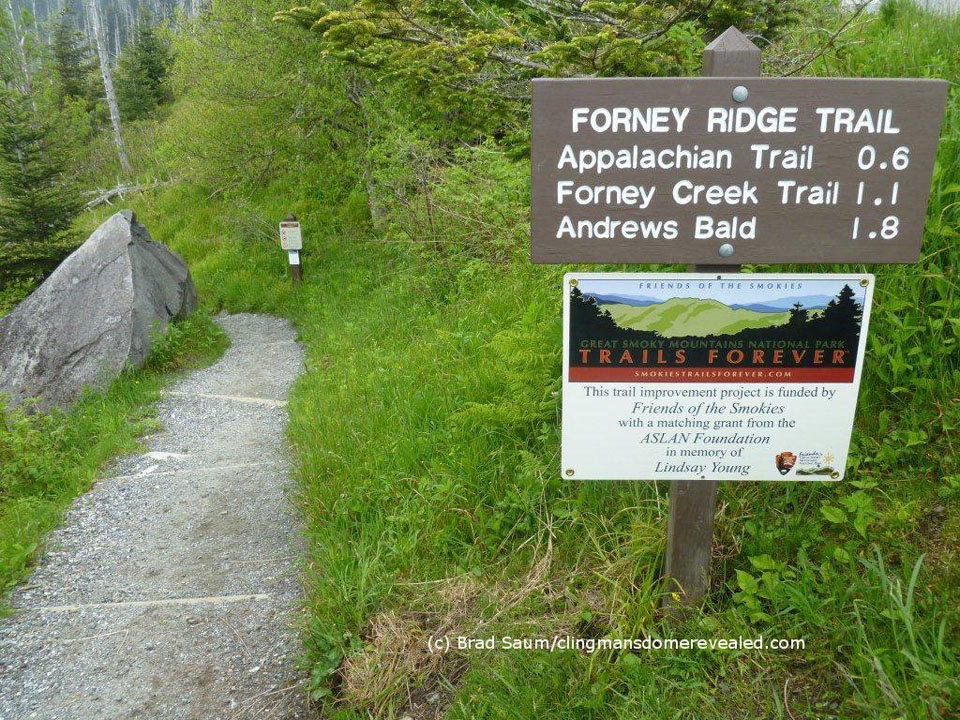
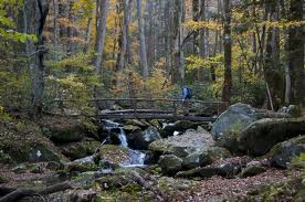
For the most part, the Forney Ridge Trail is a downhill hike for 5.6 miles and travels from the Clingmans Dome parking area all the way to the Springhouse Branch Trail. And while it is a downhill hike, it’s a steep and rocky one. So, prepare yourself accordingly with the right footwear.

To reach the trailhead, travel down Clingmans Dome Road until you reach the parking area. Between the water fountain and the path to the lookout tower, you’ll find the access trail.

It’s an uneven trail starting out and you’ll pass some large rocks before taking a left and passing the Clingmans Dome Bypass Trail. There are still fir trees that align the ridge if you’ll take notice before heading down into a patch of blackberries and raspberries.

Rocks and roots get in the way a bit too much going on down the trail so keep steady if you can. Watch out for a sharp right at mile 1.1 on the trail, but continue straight ahead. You’ll rise slightly through the forest before dropping again into Andrews Bald.

Andrews Bald is named after an early settler who herded cattle up to the bald and eventually built himself a home up there. If you’re clocking yourself, you reach Andrews Bald at mile 1.8 on the Forney Ridge Trail. There are a few offshoots on Andrews Bald that takes you to some great lookout points of Fontana Lake and the Noland Creek Valley. If it’s a clear day, take advantage of these two side trails, the views are some of the best in the entire park.

June is a rather popular month on the Bald as rhododendrons are in full color, thus the foot traffic can be pretty heavy, especially on weekends.

Continuing on the trail, you’ll hike a switchback going down on a rocky path. On the descent past Andrews Bald blackberries and various wildflowers find shelter among the number of rock outcroppings.

Following another ridge hike, you’ll drop down the trail again into more wildflower species, rhododendron, and beech trees. Large boulders can be seen along this ridge and about 2.5 miles past the bald, the trail loses its rocky texture and turns primarily to dirt. You’ve reached the intersection with the Springhouse Branch Trail. Hope this is a trail you’ll remember and visit again as you search for the best views in the Smokies.

Deeplow Gap Trail

deeplowgap1Hikers will cross their share of streams and then some, as well as hike past Little Creek Falls, along the 6.1 mile Deeplow Gap Trail.

To reach this Smoky Mountain trail from the end of Deep Creek Road, hike 3.6 miles on Deep Creek and Indian Creek Trails. At the start, you’ll hike to the right past a bench along Indian Creek. You”ll pass George Branch by bridge at approximately 0.1 miles on the trail before coming to an old homestead at 0.2 miles in.

You soon ascend the trail with George Branch following along on the left and come to backcountry campsite No. 51 soon after. Hikers continuing on will crisscross a smaller branch as you hike Deeplow Gap.

deeplowgap2
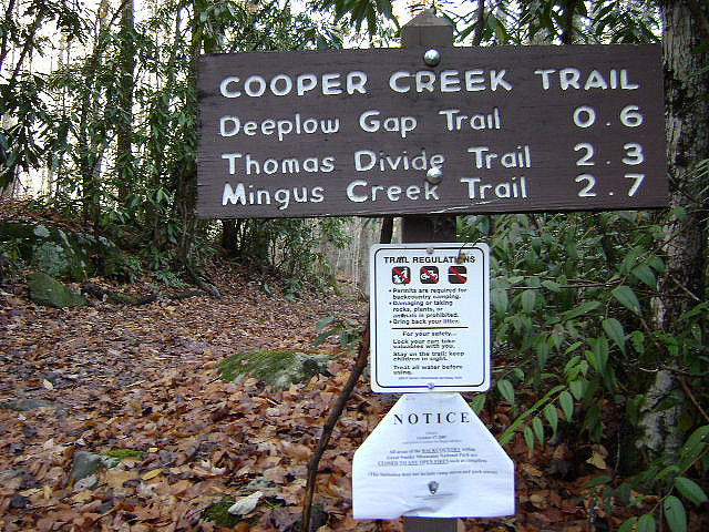
At mile 2.2, the trails meets the intersection with Thomas Divide at Deeplow Gap. Descending the divide’s eastern slope, you’ll cross by way of a foot log over Little Creek and come to the top of Little Creek Falls at 2.9 miles. You’ll descend to the base of the falls where it cascades over 95 feet to its majestic ending below. Another foot log crosses the bottom of Little Creek where you’re bound to get sprayed just a bit depending on the wind.

You’ll cross Little Creek again and some more foot logs before reaching a clearing that marks an old home site. Little Creek flows to the right till its intersection with Cooper Creek. Meanwhile, hikers come to the trail’s junction with the Cooper Creek Trail at mile 3.7, hikers will continue northward on the Deeplow Gap Trail. Another foot log is approached at 4.1 miles in and soon thereafter you’ll notice the remains of two chimneys – the site of a one-time farmhouse.

Another foot log must be crossed at 4.9 miles over Cooper Creek before ascending the ridge crest at 6.1 miles and the junction with Mingus Creek Trail. Happy hiking!

Crooked Arm Ridge Trail

Another Cades Cove trail, or “close to” Cades Cove, is the Crooked Arm Ridge trail which runs 2.2 miles from the Rich Mountain Loop trailhead to the Indian Grave Gap trail.

Starting on the Cades Cove Loop Road, walk 0.5 miles to its intersection with the Rich Mountain Loop Trail before reaching the first stream along the Crooked Arm Ridge trail at 0.2 miles. This stream eventually becomes Crooked Arm Falls, which is really only noticeable during wet weather. You’ll hop across the stream as you make your way along the trail.

Switchbacks come upon the hiker as he ascends the trail further, but don’t keep your head down or you’ll miss the many majestic views Crooked Arm provides. At 1.2 miles in, the view of Cades Cove is one many who just stick to the touristy parts of the national park miss. It’s a beautiful image of one of the park’s jewels.

As trail moves on, hikers continue over Crooked Arm Ridge and then to Pinkroot Ridge and into an oak and pine forest. You’ll want to keep your eyes from here on as a number of spectacular views come up. The first, at mile 1.9, shows you Sparks Lane as it crosses Cades Cove. You’re not far from the conclusion of the Crooked Arm Ridge trail now. At the end of it, you may turn left if you want to continue on the Rich Mountain Loop day hike.

Balsam Mountain Trail

The Balsam Mountain Trail is a 10.1 mile trail that continually rises over the first half of the trail before leveling out and reaching its finale at its meeting point with the Appalachian trail. It’s a day’s worth of good hiking and you can expect to come across wondrous mountain views and various wildflower species during the spring and summer months.

Interested parties can access the trail via its trailhead by way of the Blue Ridge Parkway. Traveling the Heintooga Ridge Road for 9 miles, you’ll enter onto Balsam Mountain Road and travel another 8.4 miles to Pin Oak Gap, where the trail begins.

Accordingly, the Balsam Mountain Trail begins in a northern hardwood forest before moving into a spruce fir forest. You’ll reach Beech Gap at mile 2.3 and notice the dip in the mountain and various patches of grass along the trail. Beech Gap Trail meanders off to the left at this point leading 2.5 miles to a place name Round Bottom. Moving further down the trail, hikers will come to Laurel Gap Shelter – a bear proof structure made of stone. At least 14 people can sleep comfortably here and there is a fire pit and a picnic table.

Past the shelter, you’ll climb another 0.2 miles before reaching the meeting of the Mount Sterling Ridge Trail. From there, you’ll notice a number of various offshoots to other trails before reaching Luftee Knob at 6.9 miles. After this, it’s a level grade for hikers and a panorama of fir forest. You’ll also notice views of Mount Hardison along the trail before a soft ascent to the Appalachian Trail junction.

Franklin, NC

“Discover Us”

Franklin is located in Southwest North Carolina and though it has a thriving commercial side it also has a lot to offer visitors of all ages when they pass through the area.  From museums and history to performing arts and beyond, Franklin brings a different palette to the table for visitors to the Smoky Mountains.

The Cherokee were the first people to call the area of Franklin, NC home.  This area had an enormous mound and was one of the sites of the sacred fire that the Cherokee had kept burning since the founding of their civilization.  With the influx of the European settler, the Cherokee were forced to relocate.  The European settlers soon found that the area was full of priceless gemstones and the mining industry took hold of what would become the city of Franklin.

The gem mining industry in North Carolina had a short-lived history.  The mines eventually became overshadowed by other countries and places in the US that could mine the gems more easily and get to market much faster.  As the industry of gem mining dried up the town of Franklin shifted to other economic methods and embraced the tourism industry as its main way of making money and supplying jobs for its citizenry.

Stats

Most Recent Posts

  • Franklin Gem and Mineral Museum - If you are interested in the lapidary arts you might want to take a ride into Franklin, NC and visit the Franklin Gem and Mineral Museum.  Due to the history of the area, it is no wonder that a museum has been established to show off the gems and the mining industry that brought Franklin … Continue reading "Franklin Gem and Mineral Museum"
  • Franklin, NC - “Discover Us” Franklin is located in Southwest North Carolina and though it has a thriving commercial side it also has a lot to offer visitors of all ages when they pass through the area.  From museums and history to performing arts and beyond, Franklin brings a different palette to the table for visitors to the … Continue reading "Franklin, NC"
  • Scottish Tartan Museum - It was easy for the people from the Highlands of Scotland to find a home in the Smoky Mountains.  They found in the Smokies a place that resembled home, a place that looked like the land they had left.  The Scottish and the Irish that live din other parts of the former British Colonies made … Continue reading "Scottish Tartan Museum"
  • Smoky Mountains Center for the Performing Arts - Places everybody! You’re likely to hear just that, or something similar, if you find yourself in the middle of Franklin, NC.  Coming from one of the side streets just off the main drag that is. The Smoky Mountain Center for the Performing Arts (SMCPA) is a hidden gem in a small, tucked away town in … Continue reading "Smoky Mountains Center for the Performing Arts"
  • History of Franklin, NC - Long before the first European settlers arrived to the mountains of Southwestern North Carolina, they were home to the Cherokee Indian Nation. In a valley surrounded by some of the oldest mountains on earth, the Cherokee called the area that is now Franklin, NC, “Nikwasi” or “center of activity”. Nikwasi was an ancient and important … Continue reading "History of Franklin, NC"

Cooper Creek Trail

The Cooper Creek Trail is another really short Smoky Mountain hike that runs 0.5 miles and is really only noteworthy for a few streams that run across the trail.

To reach the trailhead, drive down Cooper Creek Road till you reach the end. You’ll be 3 miles from North Carolina Highway 19.

coopercreek

This is another one of those connector trails found throughout the park. This one in particular connects Cooper Creek Road with the Deeplow Gap Trail. Finding a parking spot can be tricky as there are no public lots around here, it’s all private property so plan accordingly.

Walking up the road you’ll pass a gate and the park boundary. Follow the roadbed that runs beside Cooper Creek – this puts you beside the park boundary and private property. Some various wildflowers highlight this walk as well as various tree species like oak and other hardwoods.

A house appears across the creek at 0.2 miles on the trail before coming upon more rhododendron. The trail comes to its ending once hikers cross Little Creek by way of a footlog.

Hatfield & McCoy’s Dinner Feud

Everyone loves a dinner show.  You get to see world class entertainment and you get to eat a great meal at the same time.  One of the most successful dinner show locations in the Smokies is the Hatfield & McCoy’s Dinner Feud.  Taking its story from the mountain families of the Hatfields and McCoys, there is lots of comedy, lots of music, lots of dancing and lots of food.  This is the perfect evening in the Smokies – good family fun in the Smokies with great people and great food.

Most people know the story of the Hatfields and McCoys.   Two mountain families that found themselves embroiled in a feud that lasted generations. The show takes a tongue in cheek look at this feud and add a competition between the families to see who can entertain the people at the show more.  Singing, dancing, clogging and lots of comedy are brought to you by one of the best casts in Pigeon Forge.  This multi-million dollar production brings the fun and the glitz of a live show to thousands of families each season.

It is a dinner show so, of course, we have to talk about the food.  Here is what they bring each and every person that comes to show each night:

  • Hatfield & McCoy Dinner FeudFeudin’ Fried Chicken
  • Open Pit Pulled-to-Pieces Pork Barbeque
  • Southern Style Creamy Soup
  • Smashed Mashed Taters
  • Bust Y’er Jeans Pinto Beans
  • Keep It Comin’ Cornbread
  • No Tellin’ What’s In It Coleslaw
  • Granny’s Famous Specialty Dessert

You will have a table full of food.  You will find that you are full by the time you are halfway through with your chicken.  Arrive hungry and prepared to eat because there is no shortage of food at the Hatfields and McCoys Dinner Feud.

And talk about easy to find.  When you first pull into town at traffic light ‘0,’ you can see the Hatfield and McCoys theater at the top of the next hill.  Look for the Titanic and turn before you get to it and you are at the Hatfields and McCoys Dinner Feud.  Call and make reservations so that you get the best seats possible.  Let the courteous staff help you plan your evening and get you prepared for a great night out in the Smokies.  If you have been coming to the area for a number of years, you will know this location and theater as the old home of the Black Bear Jamboree.  The same folks still own the theater and they are still bringing the funny and the talent to the stage each and every show.  Come feud, come eat, come enjoy!

Hatfield & McCoy Dinner FeudHatfield & McCoy’s Dinner Feud
119 Music Rod
Pigeon Forge, TN
865-908-7469
http://www.hatfieldmccoydinnerfeud.com/
https://www.facebook.com/hatfieldmccoy

Black Bear

Classification:  Animalia – Chordata – Mammalia – Carnivora – Ursidae – Ursus – Americanus

The black Bear has long been the emblem of the Smoky Mountains.  These large mammals roam the full elevation of the Smoky Mountains looking for food and places to sleep during the winter months.  They are one of the most sought after animals to spot in the Smokies and people often determine the success of a trip to the mountains by how many bears they see during the National Park visits.

The American Black Bear has made its home in the Smokies for thousands of years.  These omnivorous creatures live off the land, follow the spring growth of plants and insects out of the higher elevations in the early spring and then higher up during the summer months where it is cooler.  In the fall, as the trees burst forth with fruit and nuts, the bears take to the trees in the valleys looking to put on pounds for their hibernation.

Black Bear
Black Bear in Cades Cove

Black bears are quadrupeds that have the ability to stand on their hind legs for short periods of times.  Most black bears in the Smokies average about 300 pounds with larger bears topping out between 500 and 600 pounds.  Though the black bear can be cinnamon colored or even white, the Smoky Mountain black bears are exclusively black.  Female black bears start to have their first litters between the ages of 3-5.  Black bear usually have 2 cubs to a litter and they are born in January or February of the year, during the hibernation period.

And speaking of hibernation… Black bears are no longer considered to be true hibernators.  Black bears reduce their metabolic rate during the winter months when food is scarce and the weather conditions are harsh.  During October and November, the bears start to bed down, choosing caves, logs and other hidden and secluded areas that are protected and well covered for their long winter’s sleep.  As their metabolic rate slows down, their bodies also go through some chemical changes that allow them to recycle their waste products, suppress their appetite and sleep for long periods of time.  During the hibernation period they will occasionally wake up but, for the most part they ‘nap’ through the cold months waiting for the spring thaw.

If one of your goals is to see a Black Bear while you are in the Smoky Mountains, then there are a few options:

  • Cades Cove – Get up early.  Be one of the first cars through the gates and you might get several bear encounters while you are cruising around the loop road.  By early, you need to be there before dawn waiting for the rangers to open the gate.
  • Clingman’s Dome – During summer, head to Clingman’s Dome.  There have been many sightings of black bears during the summer in recent years at this highest point in the Smokies.
  • Watch for Large Crowds – While the sighting of a deer will stop traffic, the sighting of a black bear will bring everything to a halt.  If you are stuck really far back in the traffic jam and you are wondering why the cars aren’t moving – it might be a bear.

Goldmine Loop Trail

An trail with the name “Goldmine” is sure to attract its share of visitors and it’s no different for the Great Smoky Mountains National Park’s Goldmine Loop Trail. It also helps that it’s a rather short trail that can be hiked over the course of a few hours.

gmlt1Located on the North Carolina side of the Smokies, the Goldmine Loop Trail is a 2-mile trail that begins at its junction with the Lakeshore Trail and ends at its intersection with the Tunnel Bypass Trail. Highlights include its meeting point with backcountry campsite No. 67, access to Fontana Lake, and a few old homesteads located along the trail.

To get there, hikers must take the Lakeshore Trail for a mile, which is located at the end of Lakeview Drive.

It’s probably safe to say that if you’re looking for gold along this trail, good luck finding it. It was more than likely named for an overzealous prospector. The trail itself begins on a ridge then begins a steep descent. You’ll pass by an old home site before passing by an old chimney on your right. A stream also lies at the site as well as an old washtub and other remnants of a once thriving farm.

The trail continues and follows the Goldmine Branch that creeps and crawls over the mountain before reaching Fontana Lake. Another homestead is reached at 0.75 miles on the trail. The rock-lined cellar of the home still remains. It’s said that wild hogs may have made their way around the site at some point due to its disjointed remains.

You’ll have to leave the trail at 0.9 miles to reach backcountry campsite No. 67 for about 300 yards. It’s considered a gently-used campsite and another old homestead can be found there as well.

The trail then follows Goldmine Branch down 0.2 miles to Fontana Lake. You’ll come to the trail’s end at 2 miles in at the Tunnel Bypass Trail. From here, you can hike to the parking area 0.4 miles on Lakeview Drive.