New River State Park

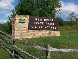
The New River State Park celebrates one of the oldest rivers in North America and the people and cultures that grew up around it.  The New River is one of the few rivers in the US that flows northward and adding that to its age, you have an unique area that is fun to explore.  The New River State Park has lots of amenities and plenty of opportunities for outdoor adventure.

The New River is in the northwestern corner of North Carolina.  Potentially, scientist think, this might be one of the oldest rivers in the US.  It was in place before the Appalachian Mountains grew up around it.  For 10,000 years or more the native people of the Smokies and the Appalachians used the New River as a waterway to transport goods back and forth between their communities.  Over the years, as the European settlers moved into the area, the New River area became a hotbed for new communities and settlements.  The easy flow of the river, the farmland surrounding the river and of course trade routes that the river provided made it a no-brainer when people were looking for a place to set up a farmstead.

New River State ParkWhile you are at New River State Park, don’t think you are going to be at a loss for things to do.  Hiking, fishing, camping and picnicking are only a few of the activities that you have to choose from .  Canoeing is probably the number one activity for people coming to the New River area.  The gently flow of the river, the gorgeous scenery around the valley that it has created and of course the relaxation that you experience as you canoe down the New River are just a few of the reasons that people flock to this area. And for flatwater kayakers, there might not be a more picturesque place to get out and play.

If the idea of the number of people that have lived in the area intrigues you, you should spend some time learning about this interesting tract of land around a truly ancient river.  The exhibit hall in the visitors center of the New River State Park houses a hands on interactive museum about the New River and the cultures that grew up around it.  From the science of the river to the native people and even modern times, you will get a look at the history and make-up of the river.  Also, they have a video on canoeing the New River.

The New River State Park in North Carolina makes for a great stop while you are on your vacation in the Smokies.  Spend a day or a weekend hanging out in one of the oldest rivers in North America.  Play in the great outdoors.  Canoe or kayak the river and experience the thrill that it has provided to people since the dawn of time.

Little River Road

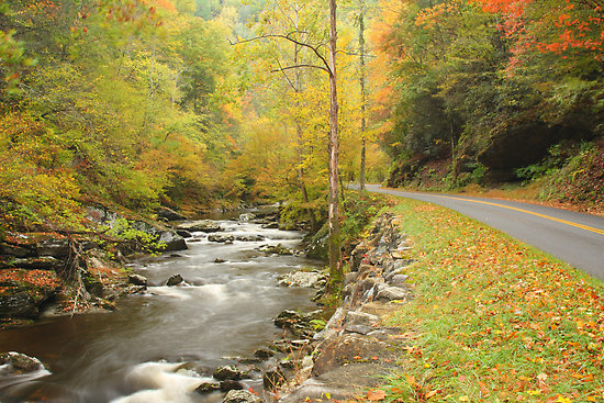
Little River Road runs from the Sugarland Visitors Center to Cades Cove.  This 18 mile stretch of road runs along the Little River and is actually built on the former railroad bed that the Little River Lumber Company used in its heyday.  This is a very popular route through the National Park.  Passing by many of the popular haunts of visitors to the Smokies it is also one of the ways to get to Cades Cove.

Highlights

  • Little River RoadElkmont – Elkmont, formerly a vacation spot for the elite from Knoxville, is one of the neatest places to visit in the Smokies.  The homes that the people lived in and vacationed in are still there.  Along with the the history there is also a campground located in Elkmont.
  • Tremont – Home to the Great Smoky Mountain Institute at Tremont, this has become a place of research and education in the Smoky Mountains.
  • The Townsend Wye – Where Lamar Alexander Parkway and Little River Road meet inside the GSMNP, is the Townsend Wye.  This is a starting point for a lot of people that love to tube in the Smokies it is also a great local swimming hole.
  • Laurel Falls – This may be the most popular trail in the Smokies and is certainly the site of the most viewed waterfall in the Smoky Mountains.
  • The Sinks – Another popular swimming hole in the Smokies, the sinks are also one of the places where you will catch people diving off the rocks into the crisp mountain water during the summer.  This is not a suggestion, as this is a very dangerous activity, merely a comment on what happens at this area of the park.

Photographer’s Paradise

Fall Foliage
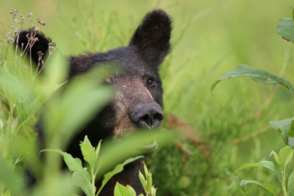
The Smoky Mountains truly are a photographers paradise.  From the wildlife that roams the area to the plants that help to make up the ecosystem to the formation of the mountains themselves, there is always something to take a picture of.  Getting out in the wilderness, driving through Cades Cove or taking one of the many hikes in the Smokies gets you into an environment to capture tremendous pictures.  If you are a photog, if you are someone that enjoys taking pictures, the Smokies hold all the wonder and excitement that you will be able to stand.

What to Bring:

  • SLR or DSLR Camera – Bring your phone camera for snapshots but if you are wanting to capture the best images that you can find, bring a good camera.  Also, if you are wanting to learn to use your camera and have a blast while you experiment,  the Smokies are one of the best places to break in new gear.
  • Tripod – For sunsets and low light conditions you are going to want a tripod.  The sunrises and sunsets in the Smoky Mountains are spectacular and a tripod will allow you to get those still images of the mountains that you will be showing off for years to come.
  • Hiking Boots and Clothes – Get off the beaten path.  If you see a tree that needs to have a picture taken of it.  Get out of the car and get up close.  Pull on the hiking boots and clothes that you don’t mind getting dirty and take a hike with your camera in hand.
  • Picnic and Plenty of Water – If you are really serious about taking pictures, you are going to be out in the wild for a while.  Bring a lunch and plenty of water and spend the day out in the elements.

Somethings to keep in Mind:

  1. If you can see it from your car… so has everyone else.  Get out of the car and get a different perspective on the scene you want to capture.
  2. Those baby bears are cute but I would bet that there mother is close by.
  3. Elk are not deer – they are bigger and much meaner.  They will charge you.
  4. Don’t be afraid to get dirty.  Changing your perspective might mean the difference between a good picture and a great picture.
  5. If you have a macro lens, you have found your new home.  The opportunities for a macro photographer are second to none in the Smoky Mountains.  From insects and amphibians to plants and wildflowers, the shots are endless.

Ramsay Cascades

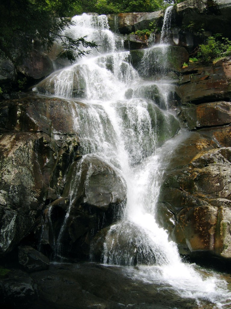
The rewards are great on this 8-mile round-trip hike in the Greenbrier section of the Park. The diligent hiker not only gets to enjoy the Ramsay Cascade falls–arguably the best waterfall in the Smokies– but also can view stands of old-growth trees which never suffered from the logger’s saw or the settler’s ax.

Summary: You have only to take this hike once to understand why it’s one of the most popular. The falls are ample reward not only for the hiker, but the artist and photographer as well. The trail starts out with a slight upgrade in the beginning, then becomes more challenging as you near the cascades. The latter portion of the trail is where you will find the old growth trees–some of which measure in record proportions. The round-trip is approximately 8 miles and can take a little over four hours, depending on whether you take children.

Directions: From Gatlinburg, drive east along US 321 (stop-light #3 in Gatlinburg) for approximately 6 miles. Turn right on Greenbrier Road and travel 3.1 miles along the Little Pigeon River to Greenbrier Cove. Turn left at Ramsay Prong Road and travel 1.5 miles to the parking area. The trail begins at the back of the parking area.

Your hike will start on the south side of the Middle Prong of the Little Pigeon River on the Ramsay Cascade Trail. You will cross the prong on a very long footbridge, and make your way past Ramsay Branch, which flows from Greenbrier Pinnacle on your left. At mile 1.5, the trail comes to a turnaround. The Greenbrier Pinnacle Trail turns off to the left. The Ramsay Cascade Trail continues forward and your climb becomes more steep.

Beside the Ramsay Prong is a primitive stand of chestnut oaks, poplars, black cherries, hemlocks, and yellow birch that forms a high canopy over the trail. Some of the largest chestnut oaks in the Smokies are found along this lower section of the trail. At higher elevations the black cherries and poplars grow to near-record sizes.

Shortly after the first crossing, the trail passes through a stand of cucumber trees. These trees are particularly enjoyable in the spring when they are sporting their bright, yellow blossoms. At the 2-mile point, before the trail crosses back to the Pinnacle Lead side of the creek, the undergrowth falls away, leaving the trail flanked by a grove of tall buckeyes, hemlocks, red maples, poplars, and tall black cherry trees, from which the section gets its name–the Cherry Orchard.

A winding passageway through huge boulders identifies the approach to Ramsay Cascades–arguably the most spectacular waterfall in the Park. Here, two streams converge to tumble nearly 100 feet over the eight stair-step ledges. It’s a marvelous place to spread out a lunch or set up the tripod and camera, or simply relax and recover from the trail.

The graded trail ends at the cascades (“Ramsay Cascades” by Gatlinburg watercolorist Vern Hippensteal at right), but more reward waits for the intrepid hiker, for approximately one-half mile above Ramsay Cascade–if you make your way through dense rhododendron–the trail approaches the creek at a memorable location known as Drinkwater Pool. Drinkwater Pool is the largest of a succession of basins on the Ramsay Prong, where the water collects in pools before continuing on to charm the visitors at the cascades. Drinkwater Pool is surrounded by ledges covered with overhanging rhododendron above which towers a stand of virgin birch. We stood in this area and imagined being the first to discover the sight. We are truly blessed to be able to enjoy such as this!

Don’t quit yet! About a half mile above Drinkwater Pool is a second cascade, which is higher and nearly as enjoyable as Ramsay Cascades. On the face of a two-hundred-foot cliff are more than a dozen small, wispy waterfalls. They catch the eye and hold it, for these falls are not aligned one after the other. Each fall has a separate ledge where the water pools before falling to the next.

For the hardiest of hikers, the Appalachian Trail waits above these falls—should you want to continue another 1.5 miles.

Gem Mining

The gem mining industry in North Carolina has been a part of that culture for decades.  When the first settlers came to the Smokies to put down roots, they discovered that the soil of the mountains contained precious and semi-precious stones.  All of a sudden, the economy in these quiet mountain towns changed.  People came to the mountains look for what they hoped would be the next gold rush in the country’s history.  And while they found some wealth and they did mine gems from the mountains, the gold rush they were hoping for never really took off.

In modern times, the land that once housed big operations that mined the hillsides, is now a tourist mecca.  And the people that still own that mine land, have decided to give those visitors to the Smokies the chance to try their hands at finding that treasure in the Smokies.  You can pan for gold, sift in a sluice for gems and in some cases even go dig the dirt out of the mountain face itself.

Jackson Hole Gem MineJackson Hole Gem MineHighlands – This roadside attraction on the road between Franklin and Highlands, has been attracting visitors for a long time.  With the promise of hot boiled peanuts on the marquee outside, you get to sit under a covered area that contains the sluice or the water trough that you use to mine gems.  The earth that you sift through has both native and enriched gemstone sin it.  Experts are on hand to help you see what you have found.

Cherokee Ruby & Sapphire MineFranklin – The Cherokee Ruby and & Sapphire Mine tries to keep it ‘real.’  If you are looking for an outdoor activity this is the place to go.  The natural stream that feeds the water flume keeps the water nice and chilly as it runs downhill.  The dirt you are sifting through is full of naturally occurring gems, some of which are of facet quality.

Smoky Mountain Gold & Ruby MineCherokee – In downtown Cherokee you can not only mine for gem stones but also pan for gold.  If your children are learning about the gold rush, there is no better way to spark their interest in history then by letting them get their hands dirty.  And at the Smoky Mountain Gold & Ruby mine you are guaranteed a find!

Greenbrier Auto Tour

Greenbrier Auto Tour
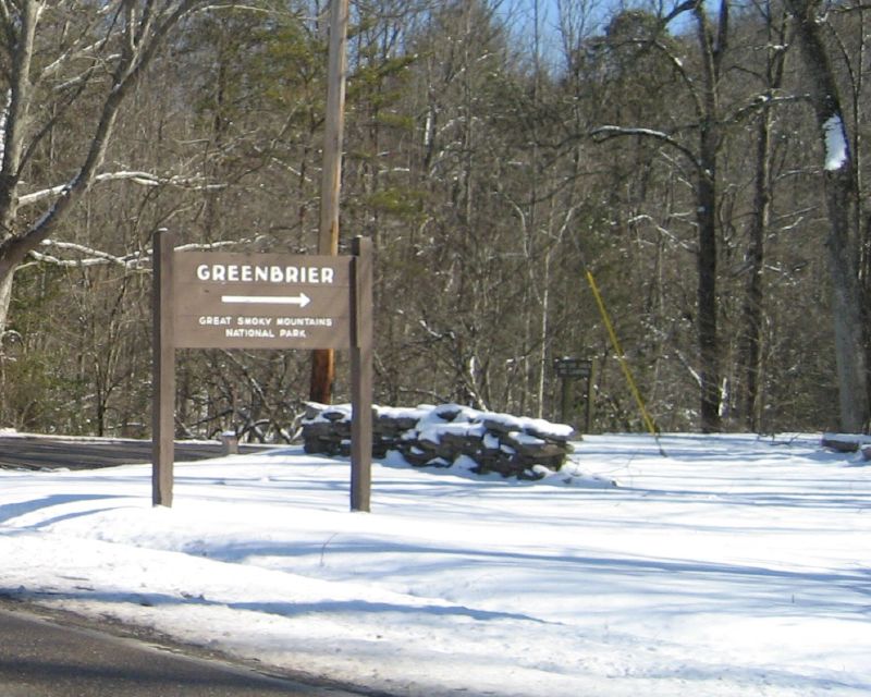
A lesser visited area of the Park, the Greenbrier section is one of our favorites. Besides the Ramsay Cascades, the visitor has the opportunity to view large stands of virgin growth such as northern red oak, eastern hemlock, and red maple. When the Park was created in 1934, old-growth forests were saved from the lumber companies and preserved for Smokies visitors.

The Greenbrier Valley is in the northern portion of the GSMNP.  The auto tour through Greenbrier is a little more rustic than the Blue Ridge or Newfound Gap but it is no less spectacular.  You drive through forests that have remained untouched for decades, maybe centuries. When you pull into Greenbrier you are pulling into history.  Here are some of the points of interest inside this 6 mile loop (some are on trails that break off from the auto tour):

  • John Messer Barn – This is the only remaining pre-park structure in the Greenbrier Cove.  Added to the National Register of Historic Places in 1976, this double cantilever barn is a gem tucked into the mountains.
  • Smoky Mountain Hiking Club Cabin (SMHC) – This cabin was constructed by the SMHC between 1934 and 1936.  This is one of the few structures in the park that was not built by the National Park Service.  Designed by the same architect that built some of the buildings for Arrowmont in Gatlinburg this was used by the SMHC until 1981.
  • Tyson McCarter Place – A Barn, a corn crib, a smokehouse and a springhouse are what remains of the Tyson McCarter Place. Located along the Old Settlers Trail, this area was added to the National Register of Historic Places in 1976
  • Baxter Cabin – This is all that is left of the Baxter spread in the Greenbrier area.  Originally consisting of 2 cabins, a barn, a corn crib, smokehouse, hogpen, chicken house and blacksmith shop, this cabin and the chicken house were left.  In the 1950s the chicken house was moved to the Oconaluftee area to the Mountain Farm Museum.  This structure is typical of the homes in the mountains in the 1880s.

To get to Greenbrier Road, leave Gatlinburg at light #3 and head east on Hwy 321. Travel for approximately 7 miles and turn right on Greenbrier Road.

The AT in the Smokies

The most hiked section of the Appalachian Trail

at logoThe southern tip of the Appalachian Mountains, with its temperate climate, slow changes in elevation and lush greenery, is a haven to hikers from around the world.  People flock to the Smokies especially to spend time on any number of trails, but the trail that is most popular and the one that a lot of people want to tackle part of is the Appalachian Trail. One end of the AT starts in the Smokies, in northern Georgia.  From that point you can work your way north to the heart of the Smokies in North Carolina and Tennessee, passing through state parks and national parks along the way.  It is a gradual climb that will inspire both awe and a renewed sense of respect for the mountain folk and Native Americans that hiked these trails season after season in the time before their were European style cities in the area.

North Georgia

In North Georgia, you will start at Springer Mountain, one of the southern most areas of the Smokies.  Technically you are in the foothills of the Smokies at this point.  The gentle slopes, the gradual climb, the verdant landscapes will help to build your anticipation as you progress north.  In this area, you will pass near towns and civilization.  The hike takes you near several state parks with facilities that are open almost year round, depending on the weather.  The North Georgia part of the AT is some of the easiest hiking that the trail has to offer.  Even if you start here when it is late spring you will find that the elevation is not high enough to give you the extremely cold temps that you will encounter in the highest elevations.

Fontana Dam

fontana damOne of the next high points on the trail that you will come across is Fontana Dam.  At this point on the AT you have made your way into North Carolina, your second state if you are heading north from Georgia.  Fontana Lake is one of those TVA created lakes that took in the small towns of Judson and Proctor (near present day Bryson City) when Fontana Dam was established in the early part of the 20th century.  As the trail winds around Fontana Dam, you are going to start to gain some serious altitude.  The elevation change will start to reveal a change in the wildlife and the flora around you.  Just north of Fontana Lake and Dam, yes you follow the dam as you start up the mountain, you will climb until you are walking the ridge of the Great Smoky Mountains in the GSMNP.  You are  also walking the Tennessee / North Carolina line at this point on the trail.

Clingman’s Dome and Newfound Gap Road

The top of the world in the Smokies is Clingman’s Dome.  You will go all the way to the top of this part of the mountain as you progress northward on the AT.  The climb to Clingman’s Dome will take some time even for the most seasoned of hikers but the breath taking views from these peaks are like no other you will find east of the Mississippi River.  As you reach the summit of the Great Smoky Mountains National Park, you will immediately start back down again.  Soon you will arrive at the most visited portion of the GSMNP, the piece of the Appalachian Trail that starts at the Newfound Gap parking area and trailhead.  From this point you can hike almost 2 miles of the AT, the most hiked portion of the 2,200 mile trail.

Roan Mountain State Park

tn nc state lineIf you were to hike from the Newfound Gap trailhead and continue northward the next focal point you are going to come to is Roan Mountain State Park in Tennessee.  If you happen to plan your hike through accordingly you can spend some time at the top of the mountain in the rhododendron garden while it is in bloom.  Bring a camera and prepare to take a lot of pictures.  With the Catawbas in bloom it is a pink and purple wonderland of color.  Roan Mountain also has lots of facilities that a Thru-Hiker might need to take advantage of like campgrounds and other amenities.

Hike the various pieces of the Appalachian Trail int he Smoky Mountains.  Take in the terrain and the sights and the sounds of nature from the trails that make up the AT.  Hike the most hiked portion of the trail and then you too can say that you hiked the AT!

Albright Grove Loop Trail

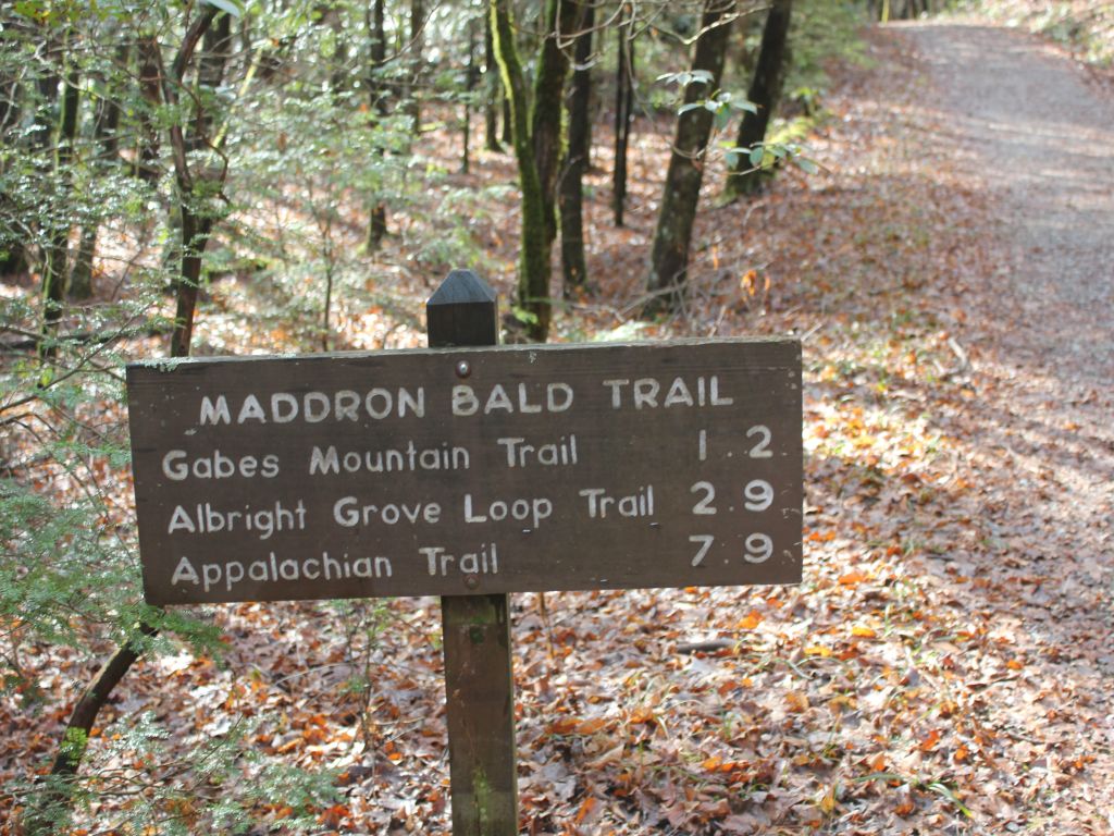
The Albright Grove Loop Trail is a short little jaunt into park great for a lunch or side trip. In all, it’s a 0.7 mile hike from the Maddron Bald Trail.

To reach the Albright Gove Loop Trail, begin at the Maddron Bald Trailhead and hike 2.9 miles along Laurel Springs Road. The trail was named to honor the second director of the national park service – Horace Albright.

A looping, twisting trail, the aptly name Albright Grove Loop Trail follows a small creek. Eastern Hemlock provide the trail with a great canopy and tuliptrees, magnolias, and maples have grown to unprecedented sizes here in this untouched heavy growth forest. Massive tree trunks also characterize this section of virgin forest.

You’ll notice that the trail will eventually level before starting downhill where hikers can be on the lookout for a giant tuliptree on the left of the trail at exactly 0.3 miles. There, you’ll also notice a small offshoot trail made by admirers. There is a giant tuliptree further down the trail that sports a trunk over 25 feet in circumference…. Literally. “Wow”!

Keeping on the trail, hemlocks among other species grow at ease before winding up a ridge, taking a rather rough turn, followed by a descent to the Maddron Bald Trail.

Cold Spring Gap Trail

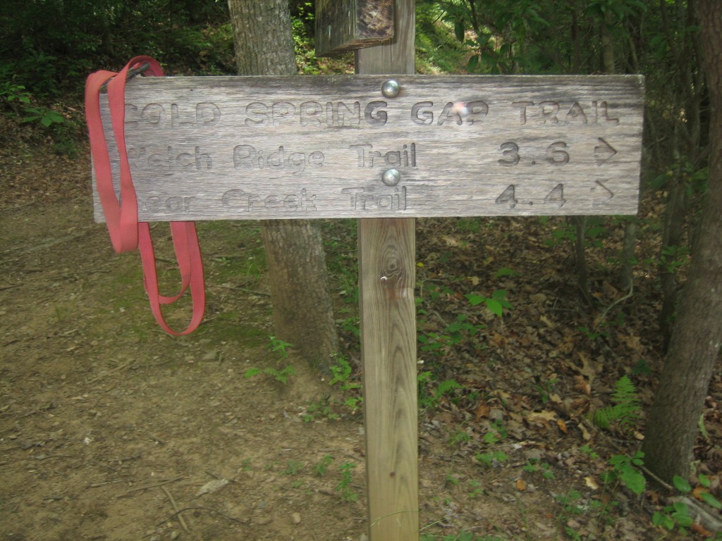
The Cold Spring Gap Trail is another wildflower trail in the Smokies best hiked in the Spring if at all possible. In all, it’s a 3.5 mile trail from its junction with the Hazel Creek Trail to the intersection with the Welch Ridge Trail.

To reach the trailhead, it’s a 6.7 mile hike from backcountry campsite No. 86 on Fontana Lake in western North Carolina near Bryson City.

The Cold Spring Gap Trail is considered more of a connector trail and follows Cold Spring Branch for much of its length. With a number of crossovers, be wary during rainy days. You’ll notice some rusted auto parts at 0.3 miles into the trail. Hazel Creek widens to about 10 feet at this point so be ready to cross it, or ready your horse. The creek’s sandy bottom is said to be the safest way, escuing the rocks.

You’ll climb a switchback after crossing the creek and pass some old home sites before crossing Cold Spring Branch at 1.2 miles. Notice the rock wall soon thereafter before more switchbacks.

A rocky, muddy trail awaits as the hiker ascends the next portion of the trail, crossing Cold Spring a number of times. Be sure to take notice of the wildflowers around here during the spring months.

You’ll reach elevations of 4,500 feet between Welch Bald and High Rocks. Hikers come to the Welch Ridge Trail soon, where it descends 7.3 miles from the AT.

Cherokee National Forest

If you have driven through Tennessee to get to the Great Smoky Mountains National Park, you have probably driven through the Cherokee National Forest (CNF).  Containing more than 650,000 acres, the Cherokee National Forest is separated by the GSMNP into two halves.  Both halves follow the state border that Tennessee shares with North Carolina.  The northern half of the CNF extends to the Virginia line to the border of the GSMNP.  In the same way the southern portion extends from the Georgia state line to the GSMNP.

Both sections of the CNF provide excellent and exciting opportunities for recreation and adventure in the Southern Appalachians.  Fishing, hiking, camping and boating are only a few activities that you can take advantage of in the CNF.

In the northern half of the Cherokee National Forest you will find:

  • Cherokee National ForestTrout Fishing – some of the streams and river sin the CNF are stocked streams and provide some of the best rainbow trout fishing in the Smoky Mountain area.  Along with trout you will find bass, crappie and bluegill fishing that is beyond compare.
  • Boating & Watersports – from sailing to skiing, the CNF is full of chance to get in the water and have a good time.
  • Hiking – Of course the most famous trail in the CNF is the Appalachian Trail.  Add to that countless other trails criss-cross the mountain terrain.
  • Camping – whether you prefer a tent or an RV, the Cherokee National Forest has a camp ground to suit your taste.

And remember, your tax dollars go to support this area.  The national forest in the US are a treasure that we need to enjoy and support.  Go explore the Cherokee National Forest, and some of the towns that are contained in this great recreational area.  In the Northern District of the CNF:  Erwin, Johnson City and Elizabethton.  To the south in the Southern District of the CNF:  Etowah and Ocee.  Spend some time in the CNF, have the vacation of your life in the great outdoors.