Rainbow Falls Trail

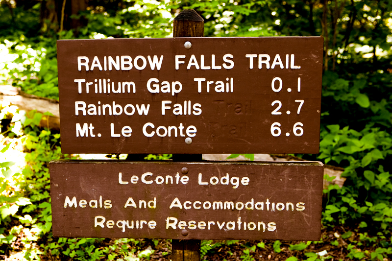
Summary: The Rainbow Falls Trail is fairly challenging if completed all the way to Mt LeConte. Allow an hour and a half to Rainbow Falls and four hours to Mt LeConte. Hikers will gain nearly 4,000 feet in elevation by the time they get to Mt. LeConte.

Point of Departure: Cherokee Orchard Road – Turn at light #8 in Gatlinburg and follow the Airport Road 1 mile out of Gatlinburg into the Great Smokies National Park. The name will change from Airport Road to Cherokee Orchard Road. About 2.5 miles after entering the Park, Cherokee Orchard Road approaches the Rainbow Falls parking area. You will find the trail head at one edge of the parking area.

Features of Interest: Your first reward comes at the 2.8 mile point when you arrive at Rainbow Falls. At the 6.6 mile point you will come upon an Alum Cave Trail junction which leads left 0.1 mile to the LeConte Lodge (the only lodging to be found within the Park), which is 6.7 miles from where you began. Overnights at LeConte Lodge require a reservation, which should be obtained weeks or even months in advance by calling (865) 429-5704.

A short jaunt to Rainbow Falls and a challenging climb on to Mt. LeConte await the hiker on The Rainbow Falls Trail. The Rainbow Falls Trail gains nearly four thousand feet in 6.7 miles, making it one of the more uniquely challenging climbs in the Smokies. The original trail is arguably the oldest route to Mount LeConte, and followed the east side of LeConte Creek. At that time, LeConte Creek was known as Mill Creek– because of the large number of grist mills that operated along the creek.

The Rainbow Falls Trail begins along the stream, and 1 mile above Cherokee Orchard, it twists away from the stream onto an exposed ridge. Shortly it returns creekside, the hiker crossing by way of a footlog, and then begins a series of climbing switchbacks.

After you cross the stream a second time, you can spot the high cliff from which the falls descend. The cliff is surrounded by a thicket of rhododendron and a growth of hemlocks.

LeConte Creek is fairly narrow at this point, and forces the water outward into a heavy mist before settling eighty-two feet below. Sunlight reflecting off this mist creates the rainbow effect which gives the falls their name.

When you cross the LeConte Creek for the third time, Rainbow Falls comes into complete view. Navigation over the rocks allows a closer approach–and a better view–of the falls. For the hardier hiker, the trail continues beyond Rainbow Falls, and becomes steeper, before changing again to a more easy course on the way to the LeConte terminus. The hiker should remember–as the trail moves up the mountain and into the cooler, moist upper reaches of LeConte–that temperatures can change considerably and unprepared hikers might find themselves in surprisingly cool temperatures–especially if it’s raining. With the change in climate, plant life changes as well. Balsam, spruce, and mountain ash dominate the trees, and crimson bee balms, asters, Indian Pipes, and monkshoods are also evident.

Note: If you have access to the internet prior to departure, you can check the general weather conditions and temperatures at different elevations. Use this only as a guideline, however, because conditions can change abruptly in the Smokies, which average 90 inches of rain each year.A short distance from the summit of Mount LeConte the Bull Head and Alum Cave Bluff trails intersect the Rainbow Falls Trail. At this point, you will be only a few hundred yards from the top of Mt. LeConte and LeConte Lodge.

Abrams Falls Trail

  • 4.2 miles in length – 2.5 miles to Abrams Falls
  • Starting Points – Abrams Falls Trailhead parking area (halfway around the Cades Cove Loop Rd)
  • Points of Interest – Abrams Creek & Abrams Falls
  • Difficulty – 1

Abrams FallsWhen you are driving around Cades Cove you are going to notice a pull off the main road about halfway around, right past a bridge.  You will see a sign for Abrams Falls.  Pull into the parking area, get your hiking gear out of the car and prepare for a journey.  This is an easy hike on a well maintained trail.  The pay off, about halfway down the trail is Abrams Falls – a gorgeous waterfall and a great place to take a dip in a mountain stream.

The trail itself is great.  From the start until almost the revelation of Abrams Falls this trail is wide enough to walk side by side with your hiking buddy.  The 2.5 miles to the falls is gently rolling with no huge increases or decreases in elevation.  Remember this is not a loop trail so you are going to have to hike back out from the falls as well.  The remaining 1.7 miles to the junction with Hannah Mountain Trail and Hatcher Mountain Trail is downfall and the trail is considerably more narrow.

The trail follows Abrams Creek from the trailhead where it is a wide creek to the falls were it plunges down the mountain.  The creek, at the trailhead, provides great opportunities to wade and frolic in the water.   The kids can get some of that restless energy from riding aroud the cove out as the splash each other and everybody else around them.  Further along the trail the creek offers some great chances to chase the elusive trout.  Abrams has some great fishing.  The first mile of the trail stays right next to the water and you can easily walk to the creek and cast while you hope to land that trophy trout in the Smokies.

The falls, though, is the highlight of the trail and the payoff for the hike.  The falls drops 20 feet into a huge round swimming hole.  Crystal clear, unless it has rained a lot recently, the water is cool even during the summer but after a brisk hike into the mountains it feels great whether you choose just to dip your feet in the water or go swimming.  The falls are one of those iconic images in the Smokies, being photographed thousands of times a year.  Remember though, even though the water is clear it is not safe to dive into the water at Abrams falls, serious injuries have occurred when people dove into Abrams Creek at the falls.