The Bradley Fork Trail makes for quite a climb along its 7.3 mile ascent. To get to the trailhead, locates at Smokemont Campground, take Newfound Gap Road to the campground and begin at the far end of D loop.
You’re bound to see a number of picturesque creeks along this hike as it winds along with the Oconoluftee River. The first 4 miles are an easy rising grade as you get used to the land before rising sharply up Hughes Ridge for 3.3 miles. Notice that there is a bridge at every creek crossing
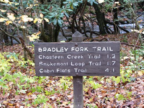
At 1.1 miles in hikers will come upon a wooden bridge before reaching the junction with Chasteen Creek Trail at 1.2 miles. Campsite No. 50 comes upon the trail soon thereafter – one of the easier sites to reach in the Smokies.
Smokemont Loop Trail is reached is bit further down the trail. If you decide to loop it out here, it’s a total of 5.5 miles before returning 3.9 miles on a strenuous route back to the Smokemont Campground.
Continuing on the Bradley Fork Trail, the forest shows ferns before you notice large sycamores and tuliptrees. A horserail comes up on the right before coming to another open section of the trail. Two bridges cross Bradley Fork where it splits and forms an island.
At the 4 mile mark, you come to a “No Camping” sign. You’ll start the climb to Hughes Ridge here – 3.3 miles away. At the trail’s junction with the Hughes Ridge Trail, you are but 2.2 miles from the Appalachian Trail and 7.3 miles from Smokemont.