Panther Creek State Park

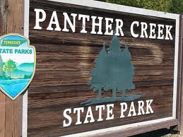
One of the many great state parks in Tennessee, Panther Creek State Park is located in Morristown, TN in the shadow of the Smoky Mountains.  This park is made up of more than 1,400 acres and houses many opportunities for outdoor activities and lots of fun.  Water sports, camping, boating and little history thrown in to boot make this an extraordinary park to visit while you are in the Smoky Mountains on vacation.  Or maybe, you live in the area and you have never ventured out to the numerous state parks in the area – what are you waiting for?

Panther Creek and Panther Springs have an interesting story behind their names.  Supposedly, the area was originally scouted by one Colonel Bradley of Virginia.  While he and his men were exploring the area, he spied a panther or a mountain lion near the spring.  He took careful aim and shot the animal which fell into the spring.  Thus he named the creek and the spring after the animal that he shot on the banks of the river.

Panther Creek State Park borders the Cherokee Reservoir.  This man made body of water was created by an impoundment of the Holston River on its way to its confluence with the French Broad River – where the Tennessee River is formed.  The Cherokee Reservoir provides a wonderful playground on the placid water.  Panther Creek State Park is about 35 miles from Knoxville and about 45 miles north of the Great Smoky Mountains National Park.

Panther Creek State ParkWhen you get to Panther Creek State Park you will find that many of the activities focus around Cherokee Lake.  Boating, boat rentals, a bait shop and more are located right on the shore of the lake.  While you are there, you might as well spend the night in one of the 50 campsites that are located around the lake.  The campsites are full service with electrical hookups, grills, picnic tables and more.  Many people come to Cherokee Lake looking to hook into a big fish.  Bluegill, catfish, crappie, bass and bream can be found in the cool waters of the lake.  Or maybe you want to go for a swim.  The campground has a swimming pool on premises with a high dive and a wading area for the little kids in your family.

If you are looking for a change of pace or just a great weekend excursion to the foothills of the Smokies, Panther Creek State Park has a lot to offer those looking for a day of fun around the lake or for a week long getaway.  Fish, camp, swim, boat and basically get outdoors spending plenty of time in the fun and the sun at Panther Creek.

Bull Head Trail

For all you locals, the Bull Head Trail is probably one you’ve heard of before, and if you’ve been to Mount LeConte might have even hiked as you made your way back to civilization.

In all, it’s a 5.9 downhill hike. We’re starting you off at the summit of Mount LeConte and traveling downward toward the Rainbow Falls Trail junction to its intersection with the Old Sugarlands Trail. For wildflowers lookers or fall color seekers, this is a perfect hiking trail and one you’re sure to come back to with the changing seasons.

Starting out, you’ll find yourself at LeConte’s West Point at the intersection with the Rainbow Falls Trail. Many choose to hike up the Rainbow Falls Trail to reach the summit of Mount LeConte and take the Bull Head Trail back down the mountain.

As mentioned this is a wonderful wildflower hike whether you decide to go during the spring or summer. Bee-balms and trout-lilies are just a few of the seasonal blooms you’re sure to notice along the way. Views are just as good, especially at points where you get to gaze down at the West Prong of the Little Pigeon River.

You come to the Pulpit at mile 3.3 of the hike – a stone cairn built by the Civilian Conservation Corps. Not only can you stand on it and look out to a majestic view, 2 or 3 people can sit on if they wish. Many a Smokies hiker have stopped to eat or take a break at this point.

From there, you’ll swing left before starting the switchbacks. This is the area known as the head of the bull – its profile seen northward. A wild buffalo bull. Talk to someone who has hiked the area over the years and they might be able to show you the whole of the bull. Balsam Point being the bull’s shoulders, the crest of Mount LeConte its body, and the Sawteeth its tail.

Magnolias, hemlocks, sugar maples meet the hiker on the way down past the Pulpit. Rock overhangs are present on this part of the trail and can provide a bit of covering during a pop-up rain storm. But be wary of these overhangs during a lightning storm. From here it’s a near straight line to the Old Sugarlands Trail.

Alum Cave Bluffs Trail

The Alum Cave Bluffs Trail is one of the most traversed in the national park and for good reason. It’s by far the most popular route to Mount LeConte as you gain 2600 feet on the way to 6400 feet.

To reach the trailhead via the Sugarlands Visitor Center in Gatlinburg, drive 8.6 miles along Newfound Gap Road traveling east. There you’ll find the sign to the trail and two large parking areas, where a path leads to the beginning of a 2.3 mile hike to Alum Cave Bluff.

The hike itself is a 4.6 mile round-trip climb following by a descent back or 5.1 miles on to LeConte Lodge. Expect the hike to the bluffs to take about 2 and 1/2 hours. Allow for about 3 and 1/2 hours if you decide to go on to LeConte Lodge.

Arch rock is the point of interest along the trail and you’ll bear witness to nature’s majestic power during this 4.6 mile (round-trip) hike. Even better views can be found if you hike on to LeConte Lodge and Cliff Tops.

Just off the parking area, you come to the Alum Cave Bluff Trailhead which is followed on its side for a mile by the Alum Cave Creek. Arch Rock appears at mile 1.5. Here, a set of stone stairs marks your passage through one of the few natural arches inside the national park. Inspiration Point appears at the 1.8 mile mark, where a panoramic view of the area meets the hiker. It’s an overwhelming sight and if you’ve packed a camera this is one of the places to use it. Low shrubs come to dot the trail from here on, before you arrive at Alum Cave Bluff (mile 2.3). Don’t take Alum Cave on name alone. Rather than a cave, it’s black slate that juts out in the form of a ledge, covering the trail and giving the impression of a cave. Alum Cave’s name derives from the alum deposits found along its walls.

If you do decide to continue and hike on to LeConte Lodge, the trail curves and follows the ridge that forms the southern flank of Mount LeConte. You’ll eventually be joined on the left by the Rainbow Falls Trail – 200 yards from it’s finish at LeConte Lodge. LeConte Lodge consists of several wood-shingled cabins, two lodges, and a dining room. There is no electricity and water is pumped into holding tanks from a spring. Reservations can be made at LeConte Lodge by calling (865) 429-5704.

Fort Loudon State Park

Fort Loudon Garrison DaysFort Loudon was built during the French and Indian War in hopes that it would act as a bridge between the people of South Carolina and the Cherokee.  Now, the fort is a state park and historic site that offers plenty of amenities to the people that visit the park throughout the year and it is also a place of living history where people from all over the country can come and learn about the French and Indian War and that time period in history.

Fort Loudon was built by the British Colony of South Carolina in 1756.  It was named for the Earl of Loudon and the people of South Carolina hoped that it would strengthen the ties between the Cherokee people and South Carolina during the French and Indian War.  Though that bond was beneficial to begin with the talks with the Cherokee broke down and on August 7, 1760, the fort fell.  The Cherokee razed the area to the ground and the site was forgotten for years.  In fact it was not until 1917 that a memorial marker was established in the place that was once the site of Fort Loudon.

Fort Loudon Garrison DaysIn modern times, you can visit a Fort Loudon that has been rebuilt to what it might have been like in its heyday.  You get to experience the time period and through living history you get to talk to the people that worked the fort.  The reenactors and volunteers make this an amazing visit for people of all ages.  They not only appear in the clothes that the people of the 18th century would have worn but they are conversant on the topic so f the day, showing crafts and skills that the people of the garrison and the communities around the fort would have possessed.  If you are really interested in that time period then you might want to plan your visit to the historic site for one of the Garrison Weekends that they have throughout the year.  On those weekends, they have crafters and vendors come in with 18th century materials and they also have a mock battle between the British from the fort and the French and Indians that would raid the fort sometimes on a daily basis.

Fort Loudon Garrison DaysOf course, this is also a state park so there is plenty to do here besides learn about the fort.  You can also play in the beautiful countryside that is East Tennessee.  Most of the Fort Loudon State Park is located on an island in Tellico Lake.  A boat dock, picnic areas and trails are only a few things that you will find to do.  The access to Tellico lake is one of the highlights and the fishing could not be better.  They even have a fishing pier that is fully handicapped accessible.

Get out in the open, spend some time outdoors.  Bring the kids to the fort and let them learn about history in a whole new way.  Explore the fort, do some hiking and get closer to history.  Experience Fort Loudon Historic State Park.

Baskins Creek Trail

Surely if you’re an avid hiker you’ve looked for those trails that everyone seems to skip over and has overgrown just enough to feel like you’re really in a remote wilderness. Trails like those still exist, a few in the Great Smoky Mountains National Park. The Baskins Creek Trail falls under that classification if only for its cryptic location.

The lovely 2.7 mile trail begins at the junction of the Trillium Gap Trail and ends in the middle of the Roaring Fork Motor Nature Trail – a very popular route for tourists coming to Smokies for the first time. It’s a wonder that the trail isn’t more traversed due to the number of popular places in the area like Grotto and Rainbow Falls.

As mentioned, the Baskins Creek trailhead is located along the Roaring Fork Motor Nature Trail. Most hikers will park along Cherokee Orchard Road and walk along the trail before coming to the trailhead.

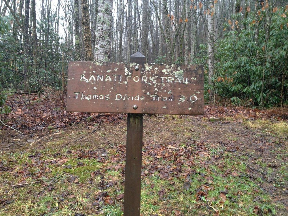
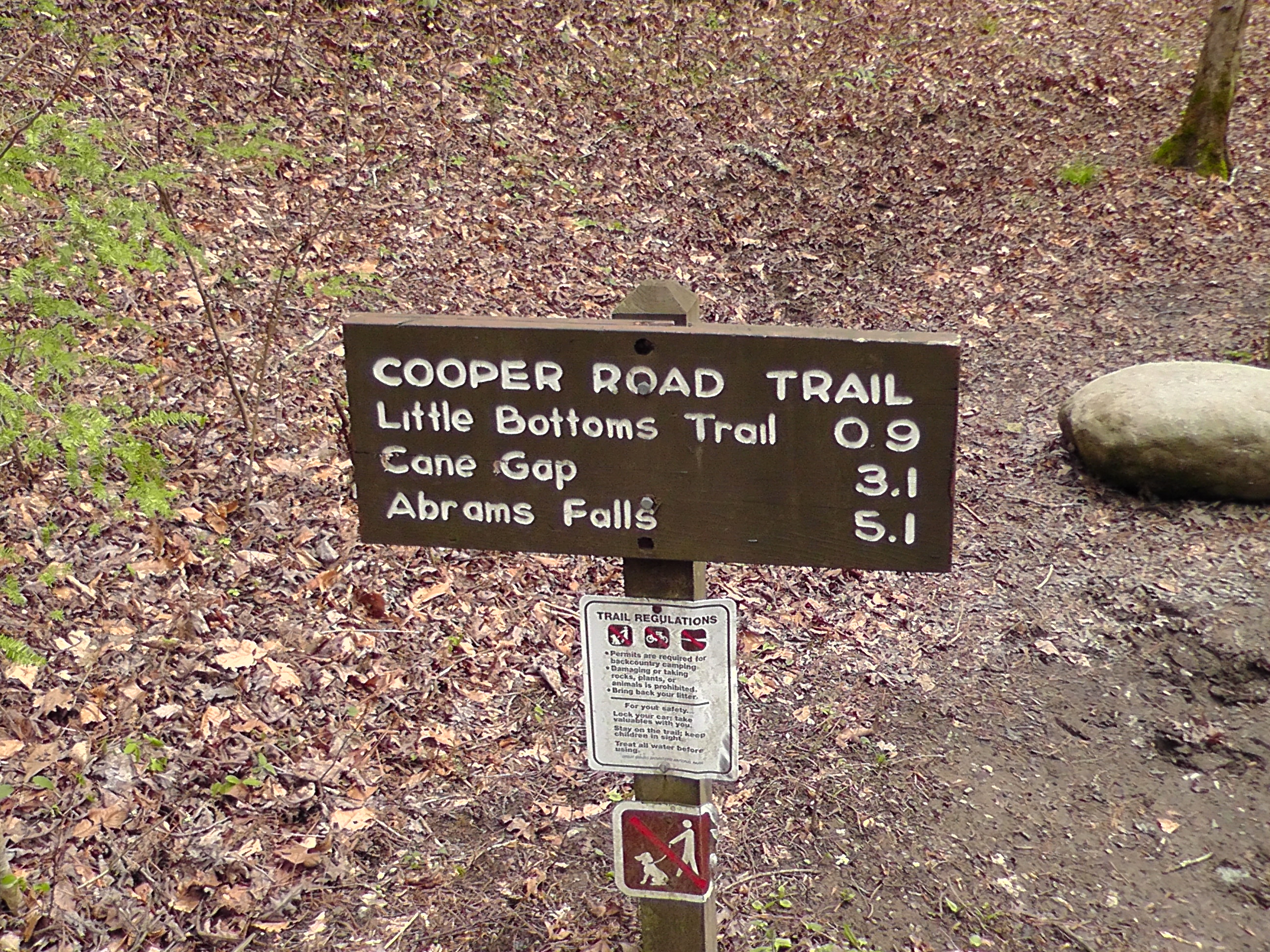
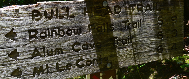
Once on the trail trail, you’ll notice various red maples, oaks, Eastern hemlocks. In winter, you can catch glimpses of Mount LeConte along the trail. You’ll cross Falls Branch at exactly 1 mile into the hike by stepping stones before descending a short ways.

Hikers will be tempted at 1.4 miles to take the side trail leading to the base of Baskins Creek Falls. Be warned, this trail is  not maintained by the national park or any other entity and is steep and can be extremely slippery for even the best of outdoorsmen.

You’ll cross Baskins Creek again at mile 1.6 after walking through a rhododendron tunnel then start a climb up a gulch where you can hear the Roaring Fork on certain days. The trail ends at the Bales Cemetery and the junction of the Roaring Fork Motor Nature Trail.

Ober Gatlinburg Set to Open Friday for Snow Tubing

*Ober Gatlinburg is scheduled to open their snow tubing park Friday, November 16th, 2012.

The idea that good skiing can only be found in the northeast or out west has been debunked by places like Ober Gatlinburg in the recent years. With the number of great changes every year to the current resort, things look to be getting even better at Ober. And that starts this year with an even earlier opening date thanks to some new snow making equipment.

Right now, officials with Ober Gatlinburg plan on opening the snow tubing area this Friday. Their new Snow Magic system has enabled the Gatlinburg resort to begin snow making even earlier, and in less than adequate temperatures.

When you think of the Ober Gatlinburg Ski Resort, you think winter sports from skiing to snowboarding and everything in between. Here, you can experience all your favorite winter sports on 8 different trails, varying from beginner to the advanced. Experience the breathtaking views and vistas of the Smoky Mountains on your way down the slopes. You’ll notice the majesty of the Smokies’ snowy peaks, white forests, and the lights of Gatlinburg. For the novice skier, or if this is your first time skiing or snowboarding, take a lesson at Ober’s Smoky Mountain Snow Sport School, located at the resort. You can take lessons as an individual or with a group. It’s a great way for families, friends, or large groups to learn how to ski.

Ober’s gear store allows people who don’t own skis or boards to rent everything they need before hitting the slopes. They offer ski gear in a variety of sizes and styles for kids and adults.

If you’re in town during the spring, summer, or fall, don’t think that Ober just shuts everything down because the temperature is a bit warmer. Ober Gatlinburg’s amusement park features some great warm weather attractions like the Alpine Slide, an indoor ice skating rink, and a scenic chairlift that takes visitors on picturesque rides up Mount Harrison. Guests will also find a waterslide, arcade, pirate ship, bungee jumping, bumper cars, Velcro jump wall, shooting range, and mini golf course at Ober. Ober Gatlinburg literally has something new around every corner. You could visit twice and still find new activities you didn’t get to try the first time.

Winter sports at Ober Gatlinburg Ski Resort is a must on everyone’s Smokies “To Do” list. Ski or snowboard the slopes, ride up and down the mountain, or just take in the spectacular views of Gatlinburg and the Smokies.

Kanati Fork Trail

The Kanati Fork Trail isn’t just a Smoky Mountain trail with a funny name. It’s a challenging uphill hike that with test even the most experienced of hikers and one where you can get some incredible shots of spring wildflowers.

In all, it’s a 2.9 mile hike from its trailhead on Newfound Gap Road to the junction with the Thomas Divide Trail. To reach the trailhead, walk 0.3 miles north of the Kephart Prong Trail parking area which is eight miles north of the Oconoluftee Visitor Center.

Like many other trails in the Smokies, the Kenati Fork Trail is a wonderful trail for viewing spring wildflowers, but it’s also a trail that can be fairly muddy if a storm has come through the area recently. The name “Kanati” comes from an old Cherokee tale, though there is no known reason as to why it was applied to this stream.

As you ascend this trail, notice the lush forest of birch and magnolia, as well as the creek valley on your left. Wildflowers that can be found along the Kanati Fork Trail include bee-balm, great chickweed, Dutchman’s britches, rue anemone, violets, trillium, and trout-lily.

Hikers will cross, then cross again, one of Kanati Fork’s feeder creeks, climb a switchback, then crosses the creek for a third time at 0.9 mile on the trail.

Thomas Divide creeps ever closer at the 2-mike marker and you cross another feeder creek before the trail levels off somewhat and another switchback come into play. At 2.9 miles, you reach the intersection with the Thomas Divide Trail and the end of the Kenati Fork Trail. Happy hiking!

Little Bottoms Trail

All you Smokies hikers out there looking for great little creek as well as backcountry campsite to camp out at need to look no further than the Little Bottoms Trail, a 2.3 miler on the Tennessee side of the park.

To get there, prepare to hike 1.3 miles by way of the Cooper Road Trail from the Abrams Creek ranger station. By the time you reach and hike Little Bottoms, you’ll have reached its junction with the Hatcher Mountain Trail.

To say that this trail gets its share of use would be an understatement. It’s THE people use to reach Abrams Falls from Happy Valley and a popular alternate route to the falls for those who wish to avoid the traffic of Cades Cove.

Starting out on the trail you’ll ascend a ridge of pine. The popular Indian Pipe blooms in abundance here from June through August in small clusters. Passing over the ridge, you’ll soon hear the flow Abrams Creek. Backcountry campsite No. 17 is reached at mile 1.6 on the trail and Abrams Creek moves musicly not far from here. An old Smokies homesite is still visible here and campers can use the creek as a water source.

The trail reaches its end at 2.3 miles at its intersection with the Hatcher Mountain Trail. Enjoy the Smokies!

Little Brier Gap Trail

As far as historical trails go in the Great Smoky Mountains, you’d be hard pressed to find a trail that packs as much history into as small a distance as the Little Brier Gap Trail.

It’s only a 1.4 mile trail, but during that time you’ll pass the Little Greenbrier School, as well as the Walker Sisters’ cabin and farm. It’s a great spot for taking shots of historic structures still standing that belonged to some of the region’s earliest settlers and some of the last to live in the park.

To get to the trailhead which is located at Little Greenbrier School, drive to Metcalf Bottoms picnic area, or hike the 0.6 mile Metcalf Bottoms Trail to the school. From the school’s parking area, the trail starts just up the hill.

As you begin your hike on the Little Brier Gap Trail, take note of the trees that surround the trail. These same species were the ones that early settlers like the Walker family used to construct their homestead – tuliptrees, white oak, maple, and beech were all used in one aspect or another to build and maintain their cabin.

After hiking three quarters of way, notice that the grassy road continues on and a gravel trails back. The grassy way takes hikers on to the Little Greenbrier Trail, the gravel road takes hikers to the Walker Sisters’ cabin. Besides the cabin, the springhouse is also still standing at the site which stored items like milk and eggs. It was said that there used to be many outbuildings that once stood on the property due to the industriousness of John Walker. Today, all that remain are the springhouse and corn crib/gear shack. A barn, pigpen, smokehouse, apple house, and blacksmith shop are said to be among the buildings that once stood on the property.

In all, 5 Walker sisters lived on the property up until 1964 when the last, Louisa Susan, passed away. They even lived on the property after the land was designated as a national park through a “life-time lease” which allowed property owners to sell their land to the park, yet live out their lives there.

Back on the trail, continue on to the trails end at the junction with the Little Greenbrier Trail where you can head east to the Laurel Falls Trail, west to Wear Cove Road, or just circle back to Little Greenbrier School. Happy hiking!


Indian Creek Trail

The Indian Creek Trail in the Smokies simply has it all – waterfalls, wildflowers, old Smoky Mountain home sites, a majestic stream valley, and all on a trail that only 3.6 miles through the Great Smoky Mountains National Park.

To reach the Indian Creek Trail, you’ll need to make your way over to Bryson City, NC first, traveling toward the Deep Creek Campground. Once you’ve arrived there, park in the Deep Creek Trail parking area then hike a little under a mile on the Deep Creek Trail to the Indian Creek Trailhead.

Of course, this trail is primarily used by campers and hikers to get to Indian Creek Falls, and we don’t blame them. It’s quite a sight. It’s a 200-foot cascade and one of the most picturesque in the entire Smoky Mountain region.

Continuing on the trail past the falls, hikers will cross Indian Creek by bridge before reaching the part of the trail where Stone Pile Gap Trail takes a right at 0.5 miles in. If you decide to follow the Stone Pile Gap Trail at some point, it travels 0.9 miles up to the Thomas Divide Trail. Keeping on the Indian Creek Trail, you’ll notice more maples and oaks dotting the forest before meeting the creek.

Loop Trail comes into view 0.8 miles on Indian Creek Trail and once you’ve hiked around 1.5 miles the trail encircles what was once an early Smoky Mountain homestead. Moving along, you’ll pass four of these such sites: the Beard farmstead, the Widow Styles place, the Hardy Styles place, and the William Laney farm. At one point these properties all had houses, barns, and various other buildings, though no more. The only real markings that remain are the clearings.

The trail eventually meets up again with Indian Creek which flows into cascades and various whirling pools as you move along the trail. Wildflowers can be seen by the hundreds in this area of the park so be sure to pack a camera.

Passing the final farmstead, the Indian Creek Trail turns back into a wooded hike before crossing Indian Creek again by bridge. The trail goes on a reaches the Deeplow Gap Trail at 2.9 miles. Four more bridges make up the final mile of the trail before reaching the junction with the Martins Gap Trail. Enjoy your adventure in the Smokies!